

North America’s got a real mix of weather, from the freezing Arctic to the balmy southeast and the dry southwest, thanks to its sheer size and different landscapes. The Rockies even have their own special climates.
All this different weather means there’s a huge variety of natural plant life. Think icy tundra up north, massive evergreen forests across Canada, leafy woods and open grasslands in the middle, dry desert plants down southwest, and a mix of forests and flatland greenery in the southeast.
Loads of different animals call North America home, all adapted to where they live. You’ve got caribou and arctic foxes in the cold, bears and moose in the woods, bison on the plains, and coyotes and rattlesnakes in the desert, plus tons of birds and sea animals.
When it comes to resources, North America’s got a lot going on. You can also find important metals like iron, copper, gold, and silver, especially in the mountains out west and up in the Canadian Shield. For power, they use water from rivers and lakes, nuclear plants, and are increasingly using things like solar panels and wind turbines.
EXERCISES
EXERCISES
A. Fill in the blanks with the correct answer.
- The northern parts of North America are ———- than the southern parts.
Ans : colder
- The ———— cause rain throughout the year along the north – west coast in the northern part of North America.
Ans : South Westerlies
- The ———– warms the Alaskan Coast and keeps it frost-free in winter.
Ans : Alaskan Current
- The tropical regions mainly experience rainfall in the ———- season.
Ans : summer
- The prairies are a vast stretch of ———- grasses.
Ans : tall
B. Match the following
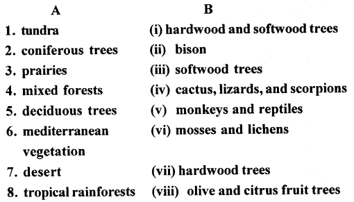
Answer:
C. Select the appropriate term from the list given below to fill in the blank after each statement
- the prairies
- chaparral
- the taiga
- the tundra
- Mediterranean climate
Ans :
- An extremely cold region which is treeless, the tundra.
- A vast stretch of coniferous forests in the cool temperate latitudes, the taiga.
- The only climate in North America which gets winter rain. Mediterranean climate.
- Grasslands where the bison are nearing extinction. The Prairies.
- The scrub-like vegetation found in coastal California. Chaparral.
Question 1.
Cool temperate east coast and west coast climates
Answer:
Cool Temperate East Coast: Think of these climates as having more dramatic swings. Summers tend to be warm and humid, while winters are often cold and snowy. They experience a good amount of rainfall throughout the year, and are sometimes hit by storms like hurricanes or nor’easters. The temperature changes more noticeably with the seasons.
Cool Temperate West Coast: Picture these climates as milder and more consistent. They’re known for their cool, wet winters and mild, relatively dry summers. The ocean has a moderating effect, keeping temperatures from getting too extreme. You’ll often see fog and a longer growing season compared to the east coast
Question 2.
Warm temperate west coast and east coast climates.
Answer:Warm Temperate West Coast: Think places like coastal California or parts of Europe bordering the Atlantic. You get mild, wet winters and warm, dry summers. Ocean currents play a big role in keeping temperatures moderate.
Warm Temperate East Coast: Picture the southeastern US or parts of eastern Asia. Here, you’ll typically see warmer, humid summers and mild winters with more precipitation throughout the year. They can also be prone to things like hurricanes or typhoons.
Question 3.
Deciduous and coniferous vegetation.
Answer:Deciduous plants are your typical leafy trees that shed all their leaves seasonally, like maples and oaks in autumn. Coniferous plants are mostly evergreen, such as pines and firs, and usually have needles or scale-like leaves and produce cones.
E. Answer the following questions in brief.
Question 1.
How does the latitudinal extent of North America affect its climate ?
Answer:The huge north-to-south distance of North America is a key factor in its diverse weather. Because it extends so far across the globe, different parts receive sunlight at different angles. The far north gets slanted sunlight, which spreads the heat thinly, resulting in the cold Arctic climate. Further south, the sunlight is more direct, concentrating the heat and causing much warmer, sometimes even tropical, conditions.
Question 2.
Identify the winds that bring summer rainfall and winter rainfall to North America.
Answer:Summer rains in North America often come from warm, humid air pulled inland from the Gulf of Mexico and the Atlantic. Winter snow and rain are mostly bought by Pacific storms traveling eastward across the continent
Question 3.
Why does the Alaskan Coast remain frost-free in the winter season ?
Answer:The Alaskan coast usually doesn’t freeze completely in winter because of warm ocean currents coming from the North Pacific. These currents act like a natural heater, keeping the coastal areas just warm enough so the water doesn’t freeze solid all the time.
Question 4.
Where are the prairies situated ? What are the major human activities in this region ?
Answer:Prairies are generally situated in the interior of continents, often in regions with moderate rainfall that isn’t quite enough to support extensive forests but is sufficient for grasslands to thrive. Think of the vast stretches of North America’s Great Plains, parts of South America (like the Pampas), and areas in Central Asia and Eastern Europe (the Steppes).
As for major human activities there:
- Agriculture is huge, especially growing grains like wheat, corn, and barley, as the fertile soil is fantastic for farming. Ranching, raising cattle and other livestock, is also very common due to the expansive grasslands.
- You’ll also find energy production, with oil and natural gas extraction being significant in some prairie regions.
- Growing urban centers and the associated industries and infrastructure have also developed in certain prairie areas.
Essentially, humans have largely transformed these grasslands into major food-producing regions and centers for resource extraction and population.
Question 5. Describe the climate and vegetation of the Mediterranean climate region of North America.
Answer: you’re describing a Mediterranean climate! That pattern of mild, wet winters followed by hot, dry summers indeed sculpts a very special plant world. You find hardy, water-wise vegetation thriving there, like the shrubby chaparral, along with oak woodlands and grasses that are resilient enough to handle the heat. It’s fascinating how those distinct seasons dictate the kind of greenery that can flourish.
Question 6. What is natural gas? What are its uses?
Answer: Natural gas is basically a naturally occurring mix of gases, mostly methane. It’s found underground and is a pretty handy energy source. We use it for tons of things, like heating our homes and water, cooking on gas stoves, generating electricity in power plants, and even as fuel for some vehicles. It’s a versatile fuel that plays a big role in our energy use.
Question 7.
North America has vast water power resources. Explain.
Answer:North America’s significant water power!
Here’s a concise explanation, sounding like it’s written by a person:
North America is blessed with a ton of rivers and lakes, many of them quite large and with significant changes in elevation. This natural geography creates a huge potential for hydroelectric power. Think about big, powerful rivers flowing down from mountains – that falling water can be harnessed to spin turbines and generate electricity. Canada and the United States, in particular, have developed many large-scale hydroelectric projects that provide a substantial amount of their power. So, it’s the combination of abundant water sources and varied terrain that makes North America a powerhouse when it comes to water energy.
G ..Map work.
On a blank outline map of North America, do as directedQuestion 1.
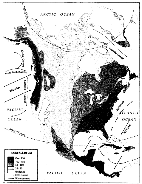
Show with black arrows the North-East Trade Winds and the South Westerlies.
Answer:
Question 2.
Use red arrows to show the warm ocean currents and blue arrows to show the cold currents that wash the shores of North America in the east and the west.
Answer:Warm and Cold Ocean Currents (Red and Blue Arrows)
- West Coast (Pacific Ocean):
- Warm Current (Red): Locate the southern part of the west coast of North America (roughly Baja California and the coast of Mexico). This represents the California Current, which, contrary to its name, has a warmer influence originating from tropical Pacific waters. (Correction: My apologies! The California Current is actually a cold current. Let’s fix that.)
- Cold Current (Blue): Draw a blue arrow moving southward along the west coast of North America, originating from the Gulf of Alaska. This represents the California Current, bringing colder waters down the coast.
- Warm Current (Red): Further north along the Alaskan coast, draw a red arrow moving northward. This represents the warmer influence of the North Pacific Current.
- East Coast (Atlantic Ocean):
- Warm Current (Red): Locate the southeastern coast of North America (Florida and the southeastern US). Draw a red arrow moving northward along this coast, curving eastward as it moves towards the open Atlantic. This is the Gulf Stream, a significant warm current.
- Cold Current (Blue): Draw a blue arrow moving southward along this coast. This represents the Labrador Current, bringing cold waters from the Arctic.
Question 3.
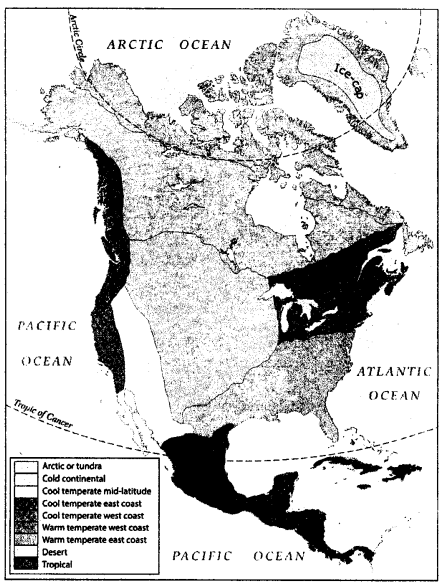
Make a key and show with different colours the different climates found in North America.
Answer:Dark Green: I’d shade the southernmost parts of Mexico and the narrow strip of Central America with a deep, lush dark green, really emphasizing that tropical rainforest feel.
Light Green: Moving north, I’d use a lighter, more open green for the southeastern United States – think Florida stretching along the Gulf Coast – and then continue that into parts of eastern and southern Mexico.
Yellow: For the arid and semi-arid regions, I’d grab a sunny yellow and color in the southwestern US – Arizona, New Mexico, and that whole dry area – extending it down into northern Mexico. I’d make sure it has that dry, almost sun-baked look.
Orange: A warm orange would cover a large chunk of the contiguous United States, excluding the far south and some of the mountainous west, and then bleed up into southern Canada. This would be that classic four-season temperate zone.
Blue: For the continental climates, I’d choose a cool blue and color in the vast interior of Canada and dip down into the northern and central parts of the US. This would visually represent those big swings in temperature between seasons.
Purple: Up in the far north, across most of Canada and Alaska, I’d use a stark purple to illustrate those long, frigid winters and short, cool summers of the polar and subarctic regions.
Brown/Gray: Finally, I’d use a textured brown or gray to trace the major mountain ranges – the long spine of the Rockies in the west and the Appalachian chain in the east. I’d try to make it look a bit uneven to suggest the varying climates with elevation
Question 4.
In each of the above climatic regions write the name/ names of the tree species that thrive there.
Answer:Way up in the Arctic, it’s too cold for most trees. You’ll only spot tiny birch and willow bushes hiding in cozy spots.
The Taiga, or Boreal Forest, is mostly made up of cone-bearing evergreen trees like spruce, fir, and pine.
In Temperate Deciduous Forests, you’ll find trees that lose their leaves each autumn, such as oak, maple, beech, and hickory.
Across the Grasslands, also known as Prairies, there aren’t many trees, though cottonwoods and willows can grow near rivers and streams.
Desserts don’t have many trees either. The ones that do live there are tough and can handle the dryness, like mesquite and certain acacia trees.
Subtropical areas have a mix of evergreen trees with broad leaves, like palms, live oaks, and magnolias, along with some pine trees.
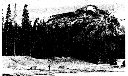
H. Picture study.
1.This is a photograph of the coniferous forests in North America.
Question 1.
Where in North America is this variety of trees found ?
Answer:Coniferous forests, like the ones in the picture, are mainly found across Canada and in the mountainous regions of the United States. This vast belt of forest is often called the Taiga or Boreal Forest and stretches from Alaska in the west, across Canada, and down into parts of the northeastern and western US. You’ll also find them at higher elevations in other parts of North America where the climate is cooler.
Question 2.
How do the animals of this region protect themselves from extreme temperatures ?
Answer:To survive the freezing temperatures in North America’s coniferous forests, animals have clever adaptations. Many grow super thick fur or layers of feathers to hold in their body heat, like bears, moose, and owls do. Some build up a cozy layer of fat under their skin for extra insulation. Others, like bears and some little rodents, go into a deep sleep called hibernation all winter long to save energy. Some animals, like certain birds and caribou, just move to warmer places when it gets really cold. Smaller creatures might dig tunnels underground or hide in tree holes where it’s more sheltered. And some even change the color of their fur or feathers to blend in with the snow, which helps them stay hidden and warm.
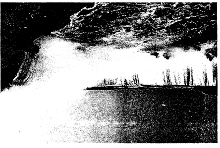
2. This is a photograph of a famous waterfall in North America.
Question 1.
Name the waterfall seen in the picture.
Answer:The waterfall in the picture is Niagara Falls.
Question 2.
Which countries get hydroelectricity from this waterfall?
Answer:The impressive energy of the Niagara River, which dramatically culminates in the renowned Niagara Falls, is a key source of hydroelectric power for two bordering countries. Canada, operating its power-generating stations in Ontario, and the United States, with its facilities located in New York State, both cleverly capture the immense force of the water to spin turbines and create environmentally friendly electricity. This joint utilization of a shared natural wonder positions Niagara Falls as a vital and sustainable energy provider for both nations, significantly supporting their power demands.
