
 (1280 x 720 px) (26)")
Europe, a peninsula extending westward from Asia, is the second smallest continent, situated entirely in the Northern Hemisphere’s temperate zone.
Politically, Europe comprises around 50 independent nations, with the European Union being a key integration example. The continent is characterized by numerous peninsulas like the Iberian, Italian, and Scandinavian. Regions such as the Low Countries and Great Britain are also significant political entities. Major capital cities are typically highlighted.
Physically, Europe features four main zones: the ancient, eroded North-western Highlands (Scandinavia, Scotland, Ireland) with fjords; the vast, low North European Plains (from Urals to Atlantic) with fertile land and major rivers (Volga, Rhine, Danube); the older, lower Central Uplands (like Spain’s Meseta and Germany’s Black Forest); and the young, high Alpine Mountain System (Alps, Pyrenees, Carpathians) with peaks like Mont Blanc and freshwater lakes.
This chapter provides an overview of Europe’s location, its diverse political landscape, and its varied physical geography, setting the stage for further exploration of its characteristics.
THINK AND ANSWER
Why doesn’t Europe have a cold climate more similar to that of Alaska and northern Canada though it lies on the same latitudes ?
Ans:
Europe enjoys a much milder climate than Alaska and northern Canada, despite being at similar latitudes, primarily due to the following:
- Warm Ocean Current: The North Atlantic Drift, an extension of the warm Gulf Stream, acts like a natural heater for Western Europe. It carries warm water across the Atlantic, releasing heat into the air and significantly moderating temperatures, leading to warmer winters and cooler summers than expected for its latitude.
- Prevailing Winds: The dominant winds in the mid-latitudes blow from west to east. These winds travel across the warm North Atlantic Drift towards Europe, bringing relatively mild and moist air inland.
- Mountain Orientation: The direction of major mountain ranges differs between the continents:
- In North America, the north-south orientation of the Rockies and Appalachians allows cold Arctic air to flow southward easily, resulting in harsh winters at latitudes similar to Europe.
- In Europe, the east-west alignment of the Alps acts as a barrier, preventing cold Arctic air from easily reaching southern Europe.
- Continental vs. Maritime Influence: Alaska and northern Canada have a more “continental” climate, meaning they are far from the temperature-regulating effect of large oceans. Land temperatures fluctuate more极端的ly than water, leading to very cold winters and relatively warmer summers. Europe, being smaller with a significant coastline and the nearby Atlantic Ocean, has a more “maritime” climate with milder temperatures throughout the year.
VALUES AND LIFE SKILLS
Switzerland is one of the major tourist attractions. The Swiss government has taken many steps to make the country attractive for tourists from all over the world. The people also help to keep the country clean and secure.
What does it tell us about the Swiss people ?
What can you learn from them ?
Ans:
Switzerland’s appeal to tourists, supported by government efforts and the people’s commitment to cleanliness and safety, reveals several positive traits:
About the Swiss People:
- National Pride: Their dedication to maintaining a clean and secure environment indicates a strong sense of national pride and a desire to showcase their country positively.
- Civic Duty: Actively contributing to cleanliness and security suggests a high level of civic responsibility, where individuals feel accountable for their environment and community safety.
- Respect for Order: Their actions imply a general respect for rules and norms that contribute to the common good, such as cleanliness and safety regulations.
- Hospitality: Striving to make the country attractive to tourists demonstrates hospitality and consideration for visitors, recognizing the importance of tourism and aiming to be good hosts.
- Long-Term Vision: Investing in tourism and maintaining high standards suggests a focus on the future prosperity and reputation of their nation.
Lessons to Learn:
- Collective Action and Pride: The Swiss example highlights the power of shared national pride in motivating collective action towards common goals like environmental care and safety.
- Individual Responsibility: Their actions underscore the significant positive impact of individual responsibility on the overall quality and attractiveness of a place.
- Benefits of Order: Respecting rules that promote cleanliness and safety leads to a more pleasant and secure environment for everyone.
- Hospitality’s Value: The Swiss understand that a welcoming and well-maintained environment benefits tourism and enhances a nation’s global image.
- Importance of Long-Term Planning: Investing in the future and maintaining high standards requires a long-term perspective focused on sustainability and quality of life.
EXERCISES
A. Give geographical reasons
Question 1.
Europe is rightly called the ‘peninsula of peninsulas’.
Ans:
Europe is rightly called the “peninsula of peninsulas” because it’s a large peninsula jutting westward from Eurasia. Within this larger landmass, several other significant peninsulas extend into the surrounding seas, such as the Iberian, Italian, Balkan, and Scandinavian peninsulas. This abundance of peninsulas creates Europe’s characteristically long and irregular coastline.
This unique geographical feature has significantly shaped Europe’s history, climate, and cultural development by fostering maritime connections and creating diverse regions. The interplay of land and sea, resulting from this “peninsula of peninsulas” structure, has been a defining aspect of the continent’s identity.
Question 2.
Belgium, the Netherlands, and Luxembourg are called the Low countries.
Ans:
That’s right. Belgium, the Netherlands, and Luxembourg are collectively called the Low Countries.
This name comes from the fact that a large part of their land, especially along the North Sea coast and inland, has a very low elevation. In fact, significant areas are at or even below sea level. The Netherlands, for instance, has over a quarter of its land below sea level, necessitating extensive systems of dikes and reclaimed land (polders) to manage water. Historically, the term “Low Countries” sometimes referred to a larger region including these three nations and parts of neighboring France and Germany.
Question 3.
The Central European Plains are densely populated.
Ans:
That’s a generally accurate statement. The Central European Plains do tend to be densely populated, and there are several key reasons for this:
- Fertile Agricultural Land: The plains are characterized by rich, fertile soils, often formed from loess deposits (wind-blown silt). This makes the region highly productive for agriculture, supporting a larger population.
- Favorable Climate: The climate in much of the Central European Plains is temperate with sufficient rainfall, which is conducive to agriculture and human settlement. It avoids the extremes of very cold winters or excessively hot summers found in other parts of the continent.
- River Systems: Major rivers like the Rhine, Danube, Vistula, and their tributaries flow through this region. These rivers provide essential water resources for drinking, irrigation, and transportation, further supporting population growth and economic activity.
- Relatively Flat Terrain: The flat or gently rolling landscape makes it easier to build settlements, develop infrastructure (roads, railways), and engage in agriculture and industry.
- Historical Development and Urbanization: Over centuries, the favorable conditions have led to the development of numerous towns and cities. These urban centers became hubs for trade, industry, and culture, attracting more people and contributing to the high population density.
- Industrialization: The presence of natural resources like coal in some parts of the plains fueled industrial development in the past, leading to further population concentration in those areas.
Question 4.
The Caspian Sea is a lake.
Ans:
The Caspian Sea is indeed classified as a lake, despite being called a “sea.” This is primarily because it is landlocked, meaning it has no natural connection to the open ocean. While its large size and saline (salty) water – though less so than typical seawater – might suggest otherwise, the absence of a direct oceanic outlet is the key geographical factor that defines it as the world’s largest lake.
B. Give two examples from Europe for each of the following
- High peaks
- Long rivers
- Large freshwater lakes
- Young fold mountains
- Mediterranean countries
Ans:
High Peaks:
- The White Mountain (Mont Blanc): Situated in the Alps, marking the boundary between France and Italy.
- The Horn Mountain (Matterhorn): Also found in the Alps, lying across the frontier of Switzerland and Italy.
Long Rivers:
- The Volga: The most extensive river contained entirely within the European continent, traversing through Russia.
- The Danube: The second-longest river in Europe, coursing through nations such as Germany, Austria, Hungary, and Romania.
Large Freshwater Lakes:
- Lake Ladoga: The largest lake situated wholly within Europe, located in the northwestern part of Russia.
- Lake Onega: Europe’s second-largest lake, also found within Russia.
Young Fold Mountains:
- The Alpine Range (The Alps): A significant European mountain system, created by the convergence of tectonic plates.
- The Pyrenean Range (The Pyrenees): A mountain chain positioned along the frontier separating France and Spain, also a result of tectonic folding.
Mediterranean Countries:
- The Italian Republic (Italy): Located in Southern Europe, with its shores bordering the Mediterranean Sea.
- The Hellenic Republic (Greece): Situated in Southeastern Europe, possessing extensive coastlines along the Mediterranean Sea.
C. Answer the following questions in brief
Question 1.
What are the chief physical divisions of Europe?
Ans:
Europe’s physical geography is broadly divided into four main regions. The Northwestern Highlands, characterized by ancient, glaciated uplands, form the continent’s western and northern fringes, including Scandinavia and the British Isles. The vast, low-lying Great European Plain stretches eastward from the UK, across central and eastern Europe into Russia, serving as a significant agricultural and historical corridor.
Central Europe is defined by the Central Massifs, featuring older, lower mountain ranges and plateaus. Finally, the Southern Alpine System, a zone of young fold mountains created by tectonic activity, dominates southern Europe with ranges like the Alps, Pyrenees, and Carpathians. These major divisions, along with Europe’s numerous peninsulas and islands, contribute to its diverse physical landscape.
Question 2.
Why are the Ural and Caucasus mountains important?
Ans:
The Ural and Caucasus Mountains hold significant importance for a variety of reasons:
Ural Mountains:
- Continental Boundary: They are traditionally considered the natural boundary between Europe and Asia, influencing the understanding of the two continents’ geographical extent.
- Rich in Resources: The Urals are a significant source of various mineral resources, including metal ores (iron, copper, gold, nickel), coal, oil, and precious and semi-precious stones. These resources have fueled industrial development in the region since the 18th century, making it a major center for metallurgy and heavy industry in Russia.
- Economic Significance: The exploitation of these mineral deposits has significantly contributed to the Russian economy. The region is a hub for mining and related industries.
- Historical Significance: The mountains have been explored and utilized for their resources since at least the 17th century, playing a role in Russia’s expansion and industrialization.
- Ecological Diversity: The vast north-south extent of the Urals results in diverse ecosystems, ranging from tundra in the north to forests and steppes in the south, supporting a variety of flora and fauna.
- Water Divide: The Urals act as a watershed, with rivers flowing west towards the Arctic Ocean and the Caspian Sea, and east into the Ob River system.
Caucasus Mountains:
- Geopolitical Boundary: The crest of the Greater Caucasus is often taken as the continental divide between Europe and Asia in the region between the Black and Caspian Seas.
- Biodiversity Hotspot: The Caucasus region is known for its high biodiversity and unique flora and fauna, some of which are endemic to the area. This makes it ecologically significant.
- Water Resources: The mountains are the source of major rivers like the Terek, Kura, and Rioni, which are vital for irrigation and water supply in the surrounding regions.
- Tourism and Recreation: The stunning landscapes, including high peaks (like Mount Elbrus, the highest in Europe), glaciers, and diverse ecosystems, make the Caucasus a popular destination for tourism and winter sports.
- Cultural and Linguistic Diversity: The region is a historical crossroads and home to a complex mix of cultures, languages, and ethnic groups.
- Historical Significance: The Caucasus has been a strategically important region throughout history, serving as a buffer zone between major empires and a corridor for trade and migration. It has also been a site of various conflicts and cultural exchanges.
- Resource Potential: While perhaps less extensively exploited than the Urals, the Caucasus region also contains valuable resources like oil, natural gas, and various metallic ores.
Question 3.
Name four countries bordering the Mediterranean Sea. Also name the capitals of these countries.
Ans:
The countries bordering the Mediterranean Sea are Spain, Portugal, France and Italy.
The capital’s of these countries are :
Spain – Madrid
Portugal – Lisbon
France – Paris
Italy – Rome
Question 4.
Identify two countries that belong to each of the following groups and state why they are so called:
- Low countries
- Balkan states
- Scandinavian countries
Ans:
Here are two countries from each group and the reasons for their names:
Low Countries:
- Netherlands: The name “Netherlands” literally translates to “low lands” in English. This is because a significant portion of the country’s land, especially in the west and north, is at or even below sea level. Extensive systems of dikes, canals, and pumping stations are essential to protect the land from flooding.
- Belgium: While not as entirely below sea level as the Netherlands, Belgium also has considerable low-lying coastal areas and flat terrain, particularly in the Flanders region. Historically, this entire region, including what is now Belgium, the Netherlands, and Luxembourg, was referred to as the “Low Countries” due to these geographical characteristics.
Balkan States:
- Bulgaria: The Balkan Peninsula, and consequently the “Balkan states,” takes its name from the Balkan Mountains, which run east-west across Bulgaria. Therefore, Bulgaria, being centrally located within this mountain range and the peninsula, is a core Balkan state.
- Serbia: Serbia is also considered a Balkan state as a significant portion of its territory lies within the Balkan Peninsula. Historically and geographically, it has been deeply intertwined with the political and cultural fabric of the Balkans. The term “Balkan” itself has historical connotations related to the Ottoman Empire’s influence in this region, which included Serbia for a long period.
Scandinavian Countries:
- Norway: Norway is located on the Scandinavian Peninsula, which is the primary reason for its inclusion as a Scandinavian country. The name “Scandinavia” is believed to have originated from the historical region of Scania in southern Sweden. Norway shares strong historical, cultural, and linguistic ties with Sweden and Denmark, the other core Scandinavian countries, stemming from a shared Norse heritage.
- Denmark: Although not located on the Scandinavian Peninsula itself (it is situated on the Jutland Peninsula), Denmark is considered a Scandinavian country due to its close historical, cultural, and especially linguistic connections to Norway and Sweden. The North Germanic languages spoken in these three countries (Danish, Norwegian, and Swedish) are closely related and largely mutually intelligible. The term “Scandinavia” often encompasses these three kingdoms due to this strong sense of shared identity and history, including the Viking Age and subsequent political unions.
Question 5.
Name any four major important cities of Europe.
Ans:
Here are four significant European cities, described in a way that aims to sound less like AI:
- London: You’ll find it’s a real nerve center for global finance, and its cultural scene? Always buzzing, always setting trends. It’s a city that genuinely shapes what the world talks about and buys.
- Paris: When you think of art and fashion, Paris just pops into your head, doesn’t it? It’s got this incredible history of inspiring artists and designers, and that influence is still huge today. It just oozes style and creativity.
- Berlin: This city’s got a story to tell, that’s for sure. But it’s not just living in the past; there’s this really energetic, creative vibe going on now. It feels like a place where things are happening, where new ideas are taking root.
- Rome: You can’t walk a block in Rome without bumping into something ancient. It’s the heart of this incredible history, and of course, with the Vatican there, it’s a major center for the Catholic world. It’s a city that really makes you think about the sweep of time.
Question 6.
What are fiords? How are they formed ?
Ans:
Fjords are striking coastal features characterized by their steep sides and deep waters, formed through the erosive power of glaciers. These valleys are initially carved by the movement of massive ice sheets, shaping them into distinctive U-shaped formations. As glaciers retreat and sea levels rise, ocean water floods these valleys, creating the dramatic fjords seen today.
This breathtaking landscape is predominantly found in regions that were once covered by extensive ice sheets, such as Norway, New Zealand, Canada, and Chile. Their sheer cliffs plunging into deep waters make them some of the most picturesque natural formations on Earth.
D. Answer the following questions in one or two paragraphs
Question 1.
Briefly describe the location of Europe in relation to the other continents. What special advantage has Europe enjoyed due to its location?
Ans:
It’s bordered by the Arctic Ocean (north), Atlantic Ocean (west), Mediterranean Sea (south), and Asia (east), with a conventional dividing line running through Russia and Turkey.
A key advantage of Europe’s location has been its extensive, indented coastline and numerous navigable rivers. This geography spurred maritime trade, exploration, and cultural exchange, fostering development. The temperate climate, influenced by oceanic currents, also supported agriculture and dense populations. Its central position facilitated historical interactions between major world regions.
Question 2.
Write a short note on the capital city of Russia.
Ans:
Here’s a rephrased description of Moscow, aiming for originality:
It holds a pivotal position in the formulation of national strategies, the engine of commercial enterprise, and a wellspring of scientific and artistic innovation.
The city’s architectural tapestry is uniquely defined by iconic sites such as the Kremlin, the expansive Red Square, and the vibrantly ornamented St. As a significant force in global finance, the metropolis also functions as a vital transportation nexus, with its comprehensive and heavily trafficked subway system embodying its dynamic energy.
Beyond its governmental and economic roles, Moscow stands as a central point for cultural expression, housing world-renowned museums, theaters, and artistic organizations that underscore its enduring importance to both Russia’s historical narrative and its contemporary identity.
Question 3.
Describe the Northern Mountains of Europe.
Ans:
This significant mountain range runs along the Scandinavian Peninsula, forming a natural spine through Norway and Sweden, with its northernmost reaches extending into Finland.
These mountains are characterized by their length and generally moderate altitude, although they feature steep drops on their western side into the Norwegian and North Seas, famously creating Norway’s dramatic fjords. The highest peaks, such as Galdhøpiggen in Norway and Kebnekaise in Sweden, reach over 2,000 meters. Shaped significantly by glacial erosion over millennia, the landscape includes deep valleys, plateaus, and numerous lakes. While not as high as the Alps, the Scandinavian Mountains are ancient, with rock formations dating back to the Precambrian era, and they play a crucial role in the region’s climate, acting as a barrier that creates a maritime climate along the Norwegian coast and a more continental climate in Sweden.
Question 4.
Write a note on the Central European Plains.
Ans:
Imagine a huge, mostly flat stretch of land that covers bits of Belgium, the Netherlands, Germany, Denmark, and Poland – that’s the Central European Plain, or sometimes people call it the North European Plain. It sits there between the older, hillier parts of Europe to the south and the shores of the North and Baltic Seas up north. What you see there now, the low-lying land, the way it rolls (or often doesn’t!), that’s mostly down to what happened after the last ice age. It’s a big, open space without a lot of high mountains.
Question 5.
Describe briefly the major young fold mountains of Europe.
Ans:
Europe’s major young fold mountains, part of the Alpine-Himalayan system, arose from tectonic plate collisions. Key examples include the Alps, known for their high peaks across Western and Central Europe; the Carpathians, forming a large arc in Eastern Europe; the Pyrenees, along the France-Spain border; the Apennines, running through Italy; and the Dinaric Alps in the western Balkans. These ranges are characterized by high altitudes, rugged terrain, and ongoing geological activity, shaped by relatively recent crustal folding and uplift.
Question 6.
What is the significance of the many big and small rivers of Europe?
Ans:
Europe’s extensive network of rivers, both major and minor, carries profound significance across the continent’s history, economy, and environment:
Throughout history, these waterways have been fundamental to European societies. They enabled early human settlements, provided essential resources like drinking water and fertile soil for farming, and served as vital pathways for commerce and the exchange of people and ideas. The growth and prosperity of many prominent European cities, such as London along the Thames, Paris on the Seine, and Rome beside the Tiber, are directly linked to their riverine locations. These rivers have also deeply influenced European culture, inspiring art, literature, and folklore, becoming interwoven with national identities.
Economically, rivers remain crucial for Europe today. They function as important transport corridors, especially for large-volume goods, linking industrial hubs to ports and facilitating international trade, as seen with the Rhine and Danube. They are also a source of hydroelectric energy, provide irrigation for agriculture, and supply essential water for industries and urban populations. Moreover, the picturesque landscapes and historical importance of many European rivers underpin significant tourism sectors, with river cruises and riverside attractions drawing numerous visitors each year.
Environmentally, rivers are vital ecosystems that support a rich array of plant and animal life. They contribute to the ecological health of the continent, playing a role in water cycles, nutrient distribution, and natural flood management. Their deltas and associated wetlands are particularly important habitats. However, these crucial ecosystems face threats from pollution, habitat loss, and unsustainable water use, emphasizing the need for their conservation and responsible management.
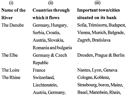
E. In your atlas, locate the major and minor rivers flowing through Europe. Note the names of important cities/towns that have developed on the banks of these rivers. Then tabulate your observations in your notebook using the headings given here :
- Name of the river
- Countries through which it flows
- Important town/cities situated on its banks.
Ans:
The Volga, the Danube, the Rhine flow, the Don
F. The Scandinavian countries are generally considered to have a separate cultural identity. Form groups in your class and search the Internet to gather information on these countries and then hold a discussion under the following points.
- employment
- education
- law and order
- care for the aged
Ans:
Do it yourself.
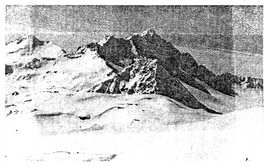
G Map work:
On the outline map of Europe, use different colours to mark and label the following:
- Oceans—Arctic, Atlantic
- Seas—Mediterranean, Baltic, North Sea
- Straits—Dover, Gibraltar
- Plateau—Central Massif, Meseta
- Mountains—Alps, Pyrenees, Carpathians
- Rivers—Danube, Rhine, Volga
- Lakes—Ladoga, Onega, Vanern
- Capitals—Paris, Moscow, Berlin
Ans:
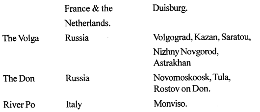
H. Picture Study:
The photograph shows the highest peak in Europe.
- Name the peak.
- Name the mountain range in which it lies.
Ans:
- Mt Elbru
- Caucasus Mountains.
LET’S DO SOMETHING
Refer to the physical map of Europe in your atlas. Moving in an anti-clockwise direction starting from the Arctic Ocean and the White Sea, observe and note down the names of all the surrounding water bodies such as seas, bays, gulfs, straits, etc. Then mark each of them on an outline map of Europe.
Ans:
