

South America, the fourth biggest continent, is mostly in the Southern Hemisphere. It’s kind of triangle-shaped, wider up north and getting pointy down at Cape Horn.
Where it’s located: It stretches from about 12 degrees north to 55 degrees south of the Equator, and from 35 to 81 degrees west. The Equator cuts across its northern part, and the Tropic of Capricorn goes through its middle. The Pacific Ocean is on its west side, the Atlantic on its east and northeast, and the Caribbean Sea is to the northwest. It’s connected to North America by the skinny land bridge called the Isthmus of Panama.
How big it is: South America covers a lot of ground, around 17.8 million square kilometers.
Its countries: There are twelve independent countries there: Argentina, Bolivia, Brazil, Chile, Colombia, Ecuador, Guyana, Paraguay, Peru, Suriname, Uruguay, and Venezuela. You’ll also find a few territories that belong to other countries, like the Falkland Islands (UK) and French Guiana (France).
What its land looks like: South America has a really varied landscape, which can be grouped into four main types:
The Andes Mountains: It has super tall peaks like Mount Aconcagua (the highest in the Western Hemisphere), active volcanoes (like Chimborazo and Cotopaxi), and high, flat areas called plateaus.
The Eastern Highlands: These are older, flatter, and not as high as the Andes, located in the east. They include the Guiana Highlands in the north, the Brazilian Highlands in the middle, and the Patagonian Plateau in the south. The Central Plains: These are huge, flat, low areas between the Andes and the Eastern Highlands. Big rivers like the Amazon, Orinoco, and the Paraguay-Paraná-Uruguay flow through here, creating large, flat basins and grassy areas known as the Pampas and Gran Chaco. The Coastal Plains: These are narrow strips of mostly flat land that run along the Pacific Ocean (on the west, next to the Andes) and the Atlantic Ocean. The western coastal plain includes the Atacama Desert, one of the driest places on Earth.
EXERCISES
A. Identify who I am
- I am a narrow neck of land that joins South America to North America and separates the Atlantic Ocean from the Pacific Ocean : Isthmus of Panama.
- I am a hot desert that lies in the western coastal region of South America and stretches across the Tropic of Capricorn : Atacama desert.
- I am one of the few gaps in the Andean Mountain chain : Uspallata Pass.
- I am the highest peak of the second highest young fold mountain chain of the world, with a height of 6,960 metres above sea level : Mt. Aconcagua.
- I have the second highest freshwater lake in the world : Lake Titicaca.
B. Write true or false.
1. The 60° W longitude passes almost through the middle of South America.
Answer. True.
2. The Orinoco Plains are called the llanos.
Answer. True.
3. The selvas are another name for the grasslands of Argentina.
Answer. False.
Correct— The pampas are another name for the grasslands of Argentina.
4. The La Plata river system drains southwards into the Atlantic Ocean.
Answer. True.
5. Lake Titicaca and Lake Poopo are saltwater lakes.
Answer. False.
Correct — Lake Titicaca and Lake Poopo are freshwater lakes.
C. Match the columns
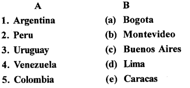
Ans :
D. Answer the following questions in brief
Question 1.
What is the latitudinal extent of South America ? In which hemisphere does the major part of it lie ?
Answer:South America extends quite a distance, starting around 12 degrees north of the Equator and reaching down to about 55 degrees south. Most of the continent lies in the Southern Hemisphere.
Question 2.
Name the water bodies that lie to the east and the west of this continent.
Answer:To the east of South America stretches the vast Atlantic Ocean. On its western side, the enormous Pacific Ocean forms its boundary.
Question 3.
Identify the major physical divisions of South America.
Answer:The towering Andes Mountains: Imagine a colossal spine running down the entire western edge of the continent. This is the Andes, the longest mountain chain on Earth, home to soaring peaks like Aconcagua and dramatic volcanoes such as Chimborazo and Cotopaxi. Nestled within these mountains are also high, expansive plateaus, like the one in Bolivia that cradles the incredibly high Lake Titicaca, a lake you could actually sail on!
The ancient Eastern Highlands: Shifting eastward, the land gives way to older, more worn-down highlands. Think of these as broad, elevated areas. In the north, you have the Guiana Highlands, further south are the Brazilian Highlands, and right at the bottom lies the rugged Patagonian Plateau.
The vast Central Plains: Sandwiched between the dramatic Andes to the west and the gentler Eastern Highlands to the east are enormous stretches of low-lying land.These rivers have carved out huge basins and created extensive grasslands, such as the grassy Pampas and the drier Gran Chaco.
The narrow Coastal Plains: Finally, bordering the continent are relatively thin strips of land right next to the oceans. Along the Pacific coast, this plain includes the Atacama Desert, a place known for being one of the driest on our planet. The Atlantic coast also has its own stretch of coastal plain
Question 4.
In what respect is the Atacama Desert different from the Patagonian Desert ?
Answer:The Atacama Desert, on South America’s west coast, is one of the driest places globally. In contrast, the Patagonian Desert, located in the rain shadow of the Andes in southern Argentina, is a cold desert. So, the main difference lies in their aridity (Atacama being extremely dry) and temperature (Patagonia being cold)
Question 5.
Name three Andean towns that are also capital cities in South America.
Answer:Here are three Andean capital cities in South America:
- Quito (Ecuador)
- Bogotá (Colombia)
- La Paz (Bolivia)
E. Answer the following questions in one or two paragraphs
Question 1.
Describe the Andes under the headings :
- Extent
- Position
- Features
- Significance
Answer:Extent and Position: The mighty Andes stretch like a spine all along South America’s western edge, making them the longest mountain range on our planet.
Features: These mountains are incredibly tall, boasting some of the highest peaks in the world, like Aconcagua. You’ll also find rumbling volcanoes, both active and dormant, dotting the range. Nestled within the Andes are high, flat areas called plateaus, such as the Bolivian Plateau, which cradles the remarkably high Lake Titicaca.
Significance: The Andes act like a natural barrier, significantly influencing the climate and weather patterns of South America. They create distinct wet and dry regions and are the source of many important rivers that flow across the continent. Historically, they were also home to the ancient Inca civilization, whose ruins still stand as a testament to their presence.
Question 2.
Explain the following : llanos, selvas, pampas and the Gran Chaco.
Answer:Llanos: These are the tropical grasslands found in the Orinoco River basin, mainly in Venezuela and Colombia. Think wide, grassy plains.
Selvas: This term refers to the dense tropical rainforests of the Amazon basin. Imagine a lush, green, and very wet environment.
Pampas: These are the vast, fertile temperate grasslands primarily in Argentina and Uruguay. Picture wide, open, grassy plains, good for farming.
Gran Chaco: This is a large, low-lying alluvial plain in the Paraná-Paraguay river basin, spanning parts of Argentina, Paraguay, Bolivia, and Brazil. It’s known for being hot and dry, becoming marshy in the rainy season.
Question 3.
How are the Eastern Highlands different from the Andes Mountains ?
Answer:South America’s eastern side features the ancient, worn-down Eastern Highlands. Think of them as old, sturdy plateaus shaped by rivers over vast amounts of time. 1 On the other hand, running like a spine down the west coast are the young and dramatic Andes Mountains. 2 These were pushed up by the Earth’s movements, creating soaring peaks and fiery volcanoes. 2 So, east is old and relatively low, while west is young and incredibly high!
Question 4.
Describe the Amazon, the largest river of South America.
Answer:The Amazon River is South America’s giant, stretching across a massive chunk of the continent. It’s the heavyweight champion of rivers, carrying more water than any other on the planet! Born high in the Andes Mountains, it flows eastward until it meets the Atlantic Ocean. The lands around the Amazon teem with an unbelievable variety of plants and animals, making its basin a super important and special natural world.
Question 5.
Describe the La Plata river system.
Answer:The La Plata river system is a significant web of rivers located in the southeast of South America. It comes into being where three major rivers converge: the Paraguay, the Paraná, and the Uruguay.
These rivers unite to create the Río de la Plata, a broad estuary that flows out into the Atlantic Ocean. This entire system acts as a drain for a vast region, encompassing portions of Brazil, Paraguay, Bolivia, Argentina, and Uruguay. It serves as a crucial route for transportation, provides water for agriculture, and sustains a rich variety of ecosystems.
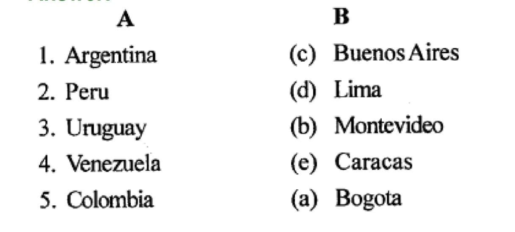
F. On a blank outline map of South America mark and name the following :
- Isthmus of Panama and Cape Horn
- Rivers Amazon, Paraguay, Uruguay and Orinoco
- Selvas, pampas, Guiana Highlands and Brazilian Highlands
- Mountain peaks — Aconcagua, Cotopaxi and Chimborazo
- Lake Titicaca and Lake Poopo
Answer:
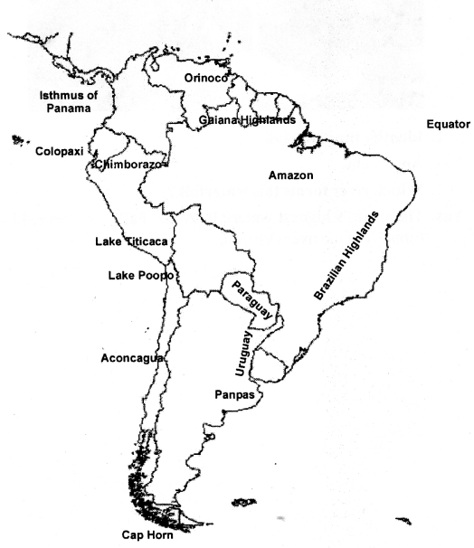
G. Picture study
The picture here shows the world’s highest waterfall, which is in South America.
Question 1.
Identify the waterfall.
Answer:The waterfall shown in the picture is Angel Falls.
Question 2.
Which river forms this waterfall ?
Answer:This amazing waterfall, known as Angel Falls, is created by the Churún River as its waters plunge down.
