
")
Humidity, the atmospheric water vapor content, is vital for weather phenomena like rain, clouds, and fog, influencing regional climates and human comfort. Geographers measure humidity using Absolute Humidity (water vapor mass per air volume), Specific Humidity (water vapor mass per dry air mass, stable despite temperature changes), and Relative Humidity (RH). RH, a percentage, indicates proximity to saturation—the maximum water vapor air can hold at a given temperature—with 100% signifying full saturation.
The transformation of water vapor into visible moisture begins with air cooling to its Dew Point, leading to condensation. This process, where vapor becomes liquid or ice, requires not only cooling but also microscopic hygroscopic nuclei. Air cools via Radiation Cooling (nighttime heat radiation), Advection Cooling (warm, moist air over cooler surfaces), and primarily Adiabatic Cooling. The latter occurs as rising air expands and cools, governed by the Dry Adiabatic Lapse Rate for unsaturated air and the slower Saturated Adiabatic Lapse Rate for saturated air, due to latent heat release during condensation.
These cooling mechanisms result in various condensation forms. Near the ground, we find dew, frost, and fog or mist. In the atmosphere, adiabatic cooling produces clouds, categorized by height and appearance into high (e.g., Cirrus), middle (e.g., Altocumulus), low (e.g., Stratus), and vertically developed types (e.g., Cumulus, Cumulonimbus). Humidity is typically measured by a Hygrometer, often a Wet and Dry Bulb Thermometer (Psychrometer), which determines relative humidity by comparing dry and evaporating wet bulb temperatures.
Exercises
I. Short Answer Questions.
Question 1.
Define the following terms :
(a) Precipitation
(b) Evaporation
(c) Condensation
(d) Humidity
(e) Latent heat.
Ans:
(a) Precipitation: It forms when atmospheric water vapor cools, condenses, and gathers into drops or ice crystals large enough to be pulled down by gravity. Common types include rain, snow, hail, and sleet.
(b) Evaporation: Evaporation is the natural process where liquid water turns into an invisible gas called water vapor, rising into the atmosphere. This occurs when water molecules gain sufficient energy, typically from the sun’s warmth, enabling them to escape the liquid’s surface and become airborne. It’s a critical component of our planet’s ongoing water cycle.
(c) Condensation: This process primarily happens when moist air reaches its dew point, causing water molecules to lose energy and cluster together, often around microscopic airborne particles called condensation nuclei. It’s essential for the formation of clouds, fog, mist, and surface moisture like dew and frost.
(d) Humidity: Humidity describes the amount of water vapor present in the air, essentially measuring its moisture content. This atmospheric characteristic can be quantified in several ways: absolute humidity (the mass of water vapor within a specific volume of air), specific humidity (the mass of water vapor relative to the mass of dry air), or most commonly, relative humidity (the percentage indicating how close the air is to its maximum water vapor capacity at a given temperature).
(e) Latent Heat: Latent heat is the thermal energy that a substance either takes in or releases during a change in its physical state—like melting, freezing, evaporating, or condensing—without experiencing a change in its temperature. This energy is “hidden” because it’s used to alter the molecular structure during the phase transition rather than causing a temperature increase or decrease. For example, latent heat is absorbed when water evaporates and released when water vapor condenses, playing a crucial role in atmospheric energy transfer and weather patterns.
Question 2.
What determines the amount of water vapour in the air?
Ans:
The quantity of water vapor in the atmosphere, known as humidity, is shaped by an interplay of several key factors. Temperature stands out as the most critical determinant; warmer air possesses a greater capacity to retain water vapor, as increased kinetic energy allows more water molecules to evaporate and remain in a gaseous state.
The availability of water sources directly influences humidity. Proximity to oceans, lakes, rivers, moist soil, and dense vegetation contributes to higher atmospheric moisture through evaporation from water bodies and transpiration from plants. Air circulation, or wind, plays a dual role: it transports moisture-rich air from humid to arid areas, increasing humidity in the latter, and also boosts evaporation rates by continuously moving saturated air away from water surfaces.
Furthermore, atmospheric pressure impacts humidity levels. Lower pressure generally correlates with higher moisture content due to less constraint on water vapor, while high-pressure systems, associated with sinking and warming air, tend to be drier. Conversely, low-pressure systems involve rising, cooling air that can hold more moisture and lead to condensation. Lastly, altitude also plays a part. While absolute water vapor typically decreases with increasing altitude due to lower temperatures and pressure, rising air cools adiabatically, often resulting in condensation and cloud formation, which can eventually release moisture as precipitation at higher elevations.
Question 3.
How is relative humidity determined ?
Ans:
Relative humidity (RH) quantifies the air’s moisture content relative to its maximum capacity at a given temperature, expressed as a percentage. It is derived by comparing the actual water vapor present with the theoretical saturation point.
A common instrument for measuring RH is the psychrometer, or wet and dry bulb thermometer. Evaporation from the wet cloth cools this bulb, with the degree of cooling directly proportional to the air’s dryness—more evaporation occurs in drier conditions, causing a greater temperature drop. Relative humidity is then ascertained by comparing the temperature differential between the two bulbs against a specific chart or table.
Beyond traditional methods, electronic hygrometers offer contemporary solutions. These devices employ capacitive or resistive sensors that detect changes in electrical properties influenced by atmospheric moisture, translating these into digital RH readings, often alongside temperature. Furthermore, precise dew point instruments can measure the dew point temperature, enabling accurate calculation of relative humidity through mathematical formulas that correlate actual vapor pressure (derived from the dew point) with saturation vapor pressure (derived from the air temperature).
Question 4.
Name four chief forms of condensation.
Ans:
Clouds: These are observable collections of minute water droplets or ice crystals, found suspended in the atmosphere at varying heights. They materialize when ascending air cools, reaching its dew point, and airborne water vapor condenses around microscopic airborne particles.
Fog: Essentially a cloud positioned at or very near the Earth’s surface, fog substantially reduces visibility. Its formation occurs when the air close to the ground cools sufficiently to reach its dew point, triggering widespread condensation.
Dew: Small droplets of liquid water, dew materializes on cool surfaces such as foliage or vehicle glass. This happens when the adjacent air cools below its dew point, causing water vapor to directly condense onto the solid surface.
Frost: Comprising delicate ice crystals, frost develops on surfaces when their temperature drops below freezing (0∘C) and the dew point is also below freezing. In this scenario, water vapor undergoes deposition, transforming directly into ice without first passing through a liquid phase.
Question 5.
Mention the different forms of precipitation.
Ans:
Rain, the most prevalent type, consists of liquid water droplets over 0.5 mm, falling when atmospheric temperatures are above freezing. Drizzle is similar but features much smaller droplets, under 0.5 mm, typically from low clouds, resulting in a fine, misty fall.
When temperatures are below freezing throughout the atmosphere, snow forms as water vapor directly freezes into intricate hexagonal ice crystals, often clumping into snowflakes. Sleet, or ice pellets, occurs when melted snow or rain falls through a freezing layer of air near the ground, refreezing into small, bouncing ice pellets. Hail, solid ice lumps typically 5 mm or larger, develop within powerful thunderstorms. Strong updrafts carry raindrops into extremely cold regions where they repeatedly freeze onto ice particles, growing in layers until they fall. Lastly, freezing rain involves liquid rain encountering a sub-freezing air layer just before impact, causing it to instantly freeze upon contact with surfaces, forming a dangerous glaze.
Question 6.
What do you understand about ‘condensation nuclei’ ?
Ans:
Condensation nuclei are tiny, airborne particles that act as the essential foundation for water vapor to condense upon, leading to the formation of cloud droplets, fog, and other forms of atmospheric moisture. Think of them as microscopic “seeds” that water molecules can cling to.
Here’s why they are so crucial:
- Facilitating Condensation: They need a surface to initiate the phase change from gas to liquid. Condensation nuclei provide this surface, making it much easier for water vapor to condense, even when the air isn’t extremely supersaturated (i.e., when the relative humidity is near or slightly above 100%).
- Sources and Types: Natural sources include dust from deserts, sea salt from ocean spray, pollen, volcanic ash, and even bacteria or fungal spores. Anthropogenic sources include smoke from fires, industrial pollution, and vehicle emissions (like soot). Some nuclei are “hygroscopic,” meaning they readily attract water, making them particularly efficient at promoting condensation.
- Impact on Weather and Climate: The presence, size, and type of condensation nuclei significantly influence cloud properties. For instance, a higher concentration of smaller nuclei can lead to more, but smaller, cloud droplets, which might make clouds brighter (reflecting more sunlight) but potentially less efficient at producing rain. Conversely, fewer, larger nuclei might result in larger droplets and more efficient precipitation. Thus, they play a fundamental role in the Earth’s water cycle, radiative balance, and overall climate system.
Question 7.
State the three types of rainfall.
Ans:
Rainfall patterns are generally divided into three main types, each driven by a unique atmospheric mechanism that causes air to rise, cool, and release its moisture.
Convectional rainfall occurs when the sun’s intense heat warms the Earth’s surface, making the air above it less dense and causing it to ascend in columns. As this warm, moisture-rich air rises, it expands and cools, leading to water vapor condensing into large cumulus clouds. This process often results in heavy, localized rain showers, frequently accompanied by lightning and thunder, and is common in tropical areas or during hot, humid afternoons elsewhere.
Orographic rainfall happens when moist air is forced upward by geographical obstacles like mountains. As the air is pushed over these elevated features, it cools due to expansion. This cooling causes the water vapor to condense, forming clouds that release significant precipitation on the windward slopes of the mountains. On the leeward side, the air descends, warms, and becomes drier, creating a “rain shadow” effect with much less rainfall.
Cyclonic or frontal rainfall develops when two air masses of different temperatures and densities meet. The warmer, lighter air mass is compelled to rise over the cooler, denser air mass along their boundary, known as a front. As the warm air ascends, it cools and its moisture condenses, resulting in extensive cloud formations and often prolonged, widespread precipitation. This type of rainfall is a defining characteristic of mid-latitude weather systems, particularly temperate cyclones.
Question 8.
What is cyclonic rainfall ?
Ans:
Cyclonic rainfall, also frequently referred to as frontal rainfall, is a type of precipitation that results from the interaction of different air masses, particularly those with contrasting temperatures and densities. It’s fundamentally linked to the formation of low-pressure systems, known as cyclones.
Here’s a breakdown of how it works:
- Meeting of Air Masses (Fronts): Cyclonic rainfall occurs when a warm, moist air mass encounters a cooler, denser air mass. The boundary where these two contrasting air masses meet is called a “front.”
- Lifting of Warm Air: Because warm air is lighter and less dense than cold air, when the two air masses converge, the warmer air is forced to rise over the cooler, heavier air. This upward movement is a key driver of condensation.
- Cooling and Condensation: As the warm, moist air ascends, it expands due to lower atmospheric pressure and cools. This cooling causes the water vapor within the air to reach its dew point, leading to condensation. This condensation forms extensive cloud systems.
There are two primary contexts for cyclonic rainfall:
- Temperate (Mid-latitude) Cyclones: These are large-scale weather systems common in the mid-latitudes (like Europe, North America, and parts of Asia).
- Tropical Cyclones: These are intense low-pressure systems that form over warm ocean waters (known as hurricanes, typhoons, or simply cyclones in different regions). While their dynamics are more complex, the core mechanism still involves the convergence and rapid ascent of moist air towards a low-pressure center, leading to exceptionally heavy and often torrential rainfall, especially near the “eye wall” of the storm.
Question 9.
How does latitude affect evaporation ?
Ans:
Latitude significantly affects evaporation due to its influence on several key environmental factors:
- Solar Radiation and Temperature: The most direct impact of latitude on evaporation stems from the amount and intensity of solar radiation received. Near the equator (low latitudes), the sun’s rays strike the Earth’s surface most directly, leading to higher average temperatures and more concentrated solar energy. This abundant energy provides the necessary heat for water molecules to gain kinetic energy and escape as vapor, resulting in high rates of evaporation. As one moves towards the poles (high latitudes), the sun’s rays strike the Earth at a more oblique angle, spreading the same amount of energy over a larger area. This leads to lower temperatures and less available energy for evaporation, consequently reducing evaporation rates.
- Humidity and Atmospheric Circulation: Latitudinal differences in solar radiation drive global atmospheric circulation patterns, which in turn influence humidity. At the equator, high temperatures cause significant evaporation and rising air (convection). This warm, moist air leads to frequent rainfall and generally high humidity, which can sometimes slightly limit further evaporation even with high temperatures, as the air is already close to saturation. In contrast, descending dry air at around 30° North and South latitude (subtropical high-pressure belts) creates arid conditions with low humidity. This dry air has a high capacity to absorb more moisture, leading to very high evaporation rates in these desert regions, provided there is a water source. Towards the poles, while temperatures are very low, the air’s capacity to hold moisture is also minimal, so evaporation rates remain low despite low humidity.
- Wind Patterns: Global wind patterns, also influenced by latitude, play a role. For instance, the trade winds in the subtropics can enhance evaporation by continuously replacing saturated air near the surface with drier air, allowing more water to evaporate. At higher latitudes, different wind patterns can also affect the rate at which water vapor is carried away.
Question 10.
Why is evaporation maximum in tropical deserts surrounded by seas ?
Ans:
It might seem counterintuitive that evaporation would be maximum in tropical deserts surrounded by seas, given that deserts are defined by their aridity. However, this phenomenon is primarily due to a specific set of atmospheric and oceanic conditions that promote high evaporation rates but simultaneously inhibit rainfall.
Here’s a breakdown of the key reasons:
- High Temperatures and Intense Solar Radiation: Tropical deserts are located in zones that receive very high levels of direct solar radiation year-round. This intense heat directly fuels evaporation from any available water source, including the surrounding seas. The lack of cloud cover (a characteristic feature of deserts) means more solar energy reaches the surface, further increasing temperatures and, consequently, evaporation rates.
- Low Relative Humidity and Dry Air: Despite being near large bodies of water, the air over tropical deserts is exceptionally dry. This is largely due to the presence of subtropical high-pressure belts (part of the Hadley Cell circulation). This dry, descending air acts like a sponge, readily absorbing any moisture available from the sea surface. The lower the relative humidity of the air, the greater its capacity to take on more moisture, thus maximizing evaporation.
- Offshore Winds (Trade Winds): Many tropical deserts, especially those on the western margins of continents, are influenced by prevailing winds (like the Trade Winds) that blow from land towards the sea. These winds, having originated over dry land, are already desiccated. When they pass over the adjacent warm oceans, they pick up moisture through evaporation, but this moisture is then carried away from the land, preventing it from reaching the desert interior and contributing to rainfall. In other cases, even if winds bring some moisture from the sea, they often warm up significantly as they pass over the hot land, further lowering their relative humidity and making condensation difficult.
- Warm Ocean Currents (in some cases): While cold ocean currents are often associated with coastal deserts (e.g., Atacama, Namib) by stabilizing the atmosphere and preventing uplift, some tropical deserts might be near warm ocean currents. Warm currents contribute to higher sea surface temperatures, which directly increases the potential for evaporation from the ocean itself. However, the overarching atmospheric circulation (subtropical highs) still largely dictates the lack of precipitation on land.
Question 11.
State the factors favouring evaporation.
Ans:
The rate at which liquid water transforms into water vapor, a process known as evaporation, is influenced by a combination of environmental conditions. Essentially, these conditions dictate how readily water molecules gain enough kinetic energy to break free from the liquid phase and enter the atmosphere as a gas.
Several key factors contribute to an increased rate of evaporation. Elevated temperatures provide more energy to water molecules, allowing them to overcome surface tension and escape into the air more easily. Low humidity, or drier air, creates a steeper moisture gradient between the water’s surface and the atmosphere, enabling the air to absorb additional water vapor more readily. Strong wind speeds further enhance evaporation by continually sweeping away the layer of air already saturated with moisture, replacing it with drier air capable of absorbing more. Lastly, reduced atmospheric pressure lessens the downward force on the water’s surface, making it easier for water molecules to escape into the less resistive atmosphere.
Question 12.
What is the instrument used for measuring humidity?
Ans:
The device employed to quantify atmospheric humidity is known as a hygrometer. Various hygrometer designs exist, each leveraging distinct physical principles to ascertain the water vapor content in the air.
One prevalent type is the Psychrometer, often referred to as a Wet and Dry Bulb Thermometer. This instrument utilizes two thermometers: one measures the ambient air temperature (the dry bulb), while the other has its bulb encased in a moist fabric (the wet bulb). Evaporation from the wet cloth cools the wet bulb; the drier the surrounding air, the more rapid this evaporation and, consequently, the larger the temperature differential between the two bulbs. This temperature disparity is then mathematically translated into a relative humidity reading.
Another ingenious design is the Hair-Tension Hygrometer. This device capitalizes on the characteristic of certain organic materials, like human or horse hair (or specific synthetic fibers), to expand when they absorb moisture and contract as they dry. These subtle changes in length are mechanically amplified to move a pointer across a calibrated scale, directly indicating the humidity level.
In contemporary usage, Digital/Electronic Hygrometers are ubiquitous. These devices incorporate electronic sensors, typically operating on resistive or capacitive principles. These electrical variations are then converted by internal circuitry into a digital display, providing precise humidity readings.
Finally, the Dew Point Hygrometer offers a direct measurement of the dew point temperature. This instrument typically features a mirrored surface that is actively cooled until a minuscule amount of condensation (dew) becomes visible on its polished exterior. The temperature of the mirror at the precise moment dew formation begins is recorded as the dew point, a fundamental value from which various humidity metrics can be derived.
Question 13.
State the process of cloud formation. Name the types of clouds.
Ans:
How Clouds Are Formed
Clouds arise from a sequence of atmospheric events. It starts with evaporation, where solar energy turns liquid water into invisible water vapor that rises. This cooling reduces its moisture-holding capacity until it reaches its dew point, becoming fully saturated. At this point, the excess water vapor undergoes condensation (or deposition into ice) onto tiny airborne condensation nuclei (like dust or salt). The resulting cloud type is influenced by temperature, moisture, and the rate of air ascent.
Varieties of Clouds
Clouds are categorized primarily by their altitude and appearance.
High-level clouds (above 6,000m) are ice crystal-based and appear thin and wispy:
- Cirrus (Ci): Feathery, white, fair weather indicators.
- Cirrocumulus (Cc): Small, rippled white puffs.
- Cirrostratus (Cs): Transparent, veil-like, creating halos.
Mid-level clouds (2,000-6,000m) are a mix of water and ice, often prefixed “Alto-“:
- Altocumulus (Ac): Wavy or globular patches.
- Altostratus (As): Gray, sheet-like, obscuring the sun.
Low-level clouds (below 2,000m) are mostly water droplets:
- Stratus (St): Flat, gray, overcast sheets, can bring drizzle (fog if at ground level).
- Stratocumulus (Sc): Lumpy, rounded masses in rows, usually fair weather.
- Nimbostratus (Ns): Dark, thick, widespread, producing continuous rain/snow.
- Cumulus (Cu): Fluffy, distinct, “fair weather” clouds (can grow larger).
- Cumulonimbus (Cb): Towering, anvil-shaped, associated with thunderstorms and heavy precipitation.
Question 14.
Name the regions which receive rainfall only in summer.
Ans:
The regions that predominantly receive rainfall during their summer months are characterized by a distinct wet-dry seasonality, primarily driven by the influence of monsoon climates and certain tropical savanna climates. These areas experience a pronounced summer wet season and a relatively dry winter, a pattern shaped by seasonal shifts in wind direction and the migration of the Intertropical Convergence Zone (ITCZ).
Key examples include South and Southeast Asia, where countries like India, Pakistan, Bangladesh, Myanmar, and parts of China, Japan, and Korea receive the bulk of their precipitation during the Northern. Similarly, Northern Australia experiences its summer monsoon during the Southern Hemisphere summer (December to February).
Furthermore, significant portions of Sub-Saharan Africa, particularly West African nations (e.g., Mali, Ghana) and parts of East and Southern Africa (e.g., Tanzania, Zimbabwe), receive their primary rainfall during their respective summer periods as the ITCZ migrates over these regions, bringing moist air. Specific tropical zones within Central and South America, such as Costa Rica and central Brazil, also exhibit prominent summer wet seasons influenced by monsoon-like atmospheric dynamics. Additionally, some inland subtropical areas bordering tropical monsoon or savanna zones, like parts of the Southwestern United States (influenced by the North American monsoon) and interior regions of China, also display a notable summer precipitation maximum with drier winters.
Question 15.
Name two regions of heavy rainfall.
Ans:
Here are two distinct regions known for receiving exceptionally high amounts of rainfall:
- Northeastern India (Meghalaya State): This region, particularly around Mawsynram and Cherrapunji in the state of Meghalaya, is globally recognized for its extreme precipitation. Mawsynram, in fact, holds the distinction of being the wettest place on Earth, receiving an astonishing average annual rainfall. The unique geography of the Khasi Hills, combined with its strategic location near the Bay of Bengal, creates a powerful orographic effect.
- Equatorial Rainforest Zones: Extensive areas straddling the Equator consistently experience very heavy rainfall. This constant influx of warm, moisture-rich air is compelled to rise, cool, and condense almost daily, resulting in frequent and substantial precipitation. Notable examples include large portions of the Amazon Rainforest in South America (such as parts of Colombia) and sections of the Congo Basin in Central Africa (like areas in Cameroon). These regions are characterized by widespread convectional rainfall occurring throughout most of the year.
Question 16.
Describe the three chief ways in which condensation occurs.
Ans:
This cooling can happen in three chief ways:
- Adiabatic Cooling (Cooling by Expansion): This is the most significant way for large-scale cloud formation. As a parcel of air rises in the atmosphere (for example, due to convection, orographic lift over mountains, or frontal uplift), the atmospheric pressure around it decreases. With less pressure pushing down on it, the air parcel expands. If this cooling continues until the rising air reaches its dew point, condensation occurs, forming clouds.
- Contact/Advective Cooling (Cooling by Contact with a Colder Surface): This occurs when a mass of warm, moist air comes into direct contact with a colder surface. The heat from the air is transferred to the colder surface through conduction. As the air near the surface cools to its dew point, condensation takes place. A common example is the formation of fog when warm, moist air blows over a cold land or water surface. Another everyday example is the condensation (dew) that forms on a cold glass of water on a humid day, or on vehicle windows overnight.
- Radiational Cooling (Cooling by Radiation): This method primarily affects air near the Earth’s surface, particularly during clear, calm nights. As the ground loses heat by radiating it into space, the air immediately above it also cools down through conduction and radiation. If this cooling continues until the air’s temperature drops to its dew point, water vapor condenses into dew, frost, or radiation fog. This process is most effective when there are no clouds to trap the outgoing terrestrial radiation.
II. Give reasons for each of the following
Question 1.
In Equatorial regions the sky often remains overcast with clouds.
Ans:
High Temperatures and Intense Convection: Equatorial regions receive direct and intense solar radiation throughout the year. This leads to consistently high temperatures, which in turn causes rapid heating of the Earth’s surface and the air directly above it. As this warm, moist air becomes less dense, it rises forcefully in powerful convection currents.
Abundant Moisture and Condensation: These regions also have a high rate of evaporation from vast oceans and lush rainforests, saturating the rising air with water vapor. As the warm, moist air ascends, it cools significantly due to expansion (adiabatic cooling). When it reaches its dew point, the abundant water vapor condenses rapidly around condensation nuclei, leading to the formation of towering cumulonimbus clouds and extensive cloud cover.
Daily Rainfall Patterns: This continuous process of heating, rising, cooling, and condensation often results in heavy, convectional rainfall occurring almost daily, typically in the afternoon. The persistent formation of these clouds and the daily precipitation contribute to the characteristic overcast skies observed in equatorial zones.
Question 2.
Human comfort depends on humidity.
Ans:
Human comfort is highly dependent on humidity, specifically relative humidity (RH). Our bodies are designed to regulate temperature, primarily through the evaporation of sweat. How effectively this process works is directly impacted by the amount of moisture in the air.
Here’s how humidity affects human comfort:
1. High Humidity (above ~60% RH):
- Feeling Hotter and Stickier: Since sweat evaporation is our body’s main cooling mechanism, when it’s inhibited, we feel much hotter and “muggy” or “sticky” than the actual air temperature suggests. This creates a sensation often described as oppressive.
- Increased Strain on the Body: Our body continues to produce sweat in an attempt to cool down, putting extra strain on the cardiovascular system. This can lead to increased heart rate, fatigue, and in extreme cases, heat exhaustion or heatstroke.
- Respiratory Issues: High humidity can make breathing feel heavier and can exacerbate symptoms for individuals with respiratory conditions like asthma or allergies, as it promotes the growth of mold, dust mites, and other allergens.
2. Low Humidity (below ~30% RH):
- Dryness: When the air is very dry, it actively draws moisture from our skin, mucous membranes (like those in our nose and throat), and eyes.
- Physical Discomfort: This can lead to dry, itchy skin, chapped lips, irritated nasal passages, dry eyes, and a scratchy throat.
- Increased Susceptibility to Illness: Dry air can also dry out the protective mucous layers in our respiratory system, making us more susceptible to airborne viruses and bacteria (like the flu or common cold) as our natural defenses are weakened.
- Static Electricity: Very low humidity can also lead to an increase in static electricity.
Ideal Humidity Range for Comfort and Health:
Most experts and organizations like ASHRAE (American Society of Heating, Refrigerating, and Air-Conditioning Engineers) recommend maintaining indoor relative humidity levels between 30% to 60% for optimal human comfort and health. Some even narrow this down to 40% to 50% for ideal conditions.
Maintaining humidity within this range helps our body’s natural cooling mechanisms function effectively and prevents the uncomfortable and potentially unhealthy effects of air that is either too wet or too dry.
Question 3.
Condensation is the reverse process of evaporation.
Ans:
Condensation is the reverse process of evaporation.
- Evaporation is when liquid water changes into water vapor (a gas), absorbing heat energy in the process.
- Condensation is when water vapor (a gas) changes back into liquid water (or ice), releasing heat energy in the process.
Question 4.
Coasts receive more rainfall than the interior of the continents.
Ans:
Coasts typically receive more rainfall than the interior of continents, and there are several key reasons for this phenomenon:
- Proximity to Moisture Source (Oceans): The most fundamental reason is the ocean itself. Oceans are vast reservoirs of water, and continuous evaporation from their surface releases immense amounts of water vapor into the atmosphere. This moisture-laden air is readily available to coastal areas. As you move further inland, the influence of this primary moisture source diminishes.
- Prevailing Winds (Onshore Winds): Many coastal regions are subject to onshore winds, meaning winds that blow from the sea towards the land. These winds directly transport the moist air evaporated from the oceans inland. As this moisture-rich air moves over the land, it’s more likely to cool and condense.
- Orographic Lift (Coastal Mountains/Hills): If a mountain range or significant hills are located near the coast, they can significantly enhance rainfall. As moist air from the ocean is forced to rise over these elevated landforms, it undergoes adiabatic cooling.
- Convectional Rainfall (especially in tropical coasts): Coastal areas, especially in tropical zones, experience intense solar heating. The combination of readily available moisture from the ocean and high temperatures leads to strong convection currents. As the warm, moist air rises rapidly, it cools, condenses, and forms towering cumulonimbus clouds, resulting in frequent and heavy convectional rainfall.
- Frontal Systems (Temperate Coasts): In temperate regions, coastal areas are often the first points of contact for frontal systems (where warm and cold air masses meet) originating over the ocean. These systems bring widespread cloud cover and precipitation as the warmer, moister air is lifted over cooler air.
Why the Interior is Drier:
- Distance from Moisture Source: As air masses travel further inland, they progressively lose their moisture through precipitation. By the time they reach the interior, they are considerably drier.
- Continental Effect: Interiors of continents often experience more extreme temperature variations (hotter summers, colder winters) and tend to be drier because they lack the moderating influence of large bodies of water.
- Rain Shadow Effect: If mountain ranges exist between the coast and the interior, they can block moisture, casting a significant rain shadow over the inland areas.
Question 5.
The windward sides of mountains receive more rainfall than the leeward sides.
Ans:
Mountainous Rainfall Disparity: The Orographic Phenomenon
It’s a well-established geographical principle that one side of a mountain range experiences significantly more rainfall than the other, a concept known as the Orographic Effect. This climatic disparity arises from the interaction of moist air masses with elevated terrain.
The process begins when moisture-laden air, often originating from oceans and propelled by prevailing winds, encounters a formidable mountain barrier. Lacking any alternative path, this air mass is compelled to ascend along the mountain’s slope—a mechanism termed orographic lift. As the air gains altitude, it enters zones of progressively lower atmospheric pressure. This pressure reduction causes the air to expand and consequently cool (an adiabatic process).
At this precise temperature, the excess water vapor can no longer remain gaseous and begins to condense into myriad tiny liquid water droplets or ice crystals, forming clouds. These developing clouds, continuously fed by the uplifted moist air, release their accumulated moisture as precipitation (such as rain or snow) onto the side of the mountain directly facing the incoming winds. This side is famously known as the windward side, and it is characterized by lush vegetation and abundant water resources.
Conversely, after traversing the mountain crest, the now drier air begins its descent down the opposite slope. This side is termed the leeward side, often referred to as a “rain shadow” region. As the air descends, it experiences increasing atmospheric pressure, causing it to compress and warm up (another adiabatic process). This warming significantly enhances the air’s moisture-holding capacity, effectively evaporating any remaining moisture. The result is a much drier, often arid or semi-arid climate on the leeward side, starkly contrasting with the wet conditions on the windward slope.
Illustrative Examples:
- India’s Western Ghats: These mountains intercept the southwest monsoon winds, causing heavy rainfall on their western, windward slopes, while creating a notable rain shadow over the Deccan Plateau to their east.
- North America’s Sierra Nevada and Cascade Ranges: Similar to the Western Ghats, these ranges capture moisture from Pacific Ocean winds on their western flanks, leading to abundant precipitation and snowpack, while their eastern sides are considerably drier.
- The Andes Mountains (South America): The eastern slopes of the Andes, particularly in regions like Patagonia, receive significantly less moisture than their western, windward counterparts due to the rain shadow effect.
III. Match the following
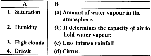
Ans:

IV. Long Answer Questions.
Question 1.
Distinguish between Absolute Humidity and Relative Humidity.
Ans:
| Feature | Absolute Humidity (AH) | Relative Humidity (RH) |
| Definition | The actual mass of water vapor present in a given volume of air. | The ratio of the actual amount of water vapor in the air to the maximum amount it can hold at a specific temperature, expressed as a percentage. |
| Formula (Typical) | Mass of water vapor / Volume of air (e.g., g/m³) | (Actual water vapor content / Maximum water vapor capacity at that temperature) × 100% |
| Units | Grams per cubic meter (g/m³) or sometimes grams per kilogram (g/kg) of dry air. | Percentage (%) |
| Temperature Dependence | Less dependent on temperature for its value, as it measures the actual amount of moisture. The volume of air does change with temperature, which can affect the density. | Highly dependent on temperature. As temperature increases, RH decreases (assuming constant actual moisture), and as temperature decreases, RH increases. |
| Indicates | The total quantity of water vapor in the air. | How saturated the air is; how close it is to the dew point. |
| Human Comfort | Less directly related to human comfort perception. | Directly related to human comfort (how “sticky” or “dry” the air feels). |
| Use Case | More useful for scientific and engineering calculations (e.g., in drying processes, air conditioning design) where the actual mass of water needs to be precisely tracked. | More commonly used in daily weather forecasts, climate discussions, and for understanding human comfort. |
| Change with Temperature (fixed moisture) | Generally remains constant for a given mass of air with its water vapor content (though volume changes with temperature). | Changes significantly; increases as air cools, decreases as air warms. |
Question 2.
With reference to condensation, define the following :
(a) Process of condensation.
(b) Atmospheric conditions that favour condensation.
(c) Forms of Condensation.
Ans:
Here’s a rephrased and unique take on the definitions related to condensation:
(a) The Mechanism of Condensation: Condensation is the critical atmospheric shift where invisible water vapor (gaseous water) reverts into its visible liquid droplet or solid ice crystal form. This transformation is primarily triggered when an air mass cools sufficiently to reach its dew point – the specific temperature at which it achieves complete saturation with water vapor. Upon reaching this point, the individual water molecules, having lost thermal energy, begin to coalesce. This aggregation predominantly happens around minute, suspended atmospheric particles referred to as condensation nuclei, and notably, this phase change simultaneously releases latent heat into the surrounding environment.
(b) Environmental Factors Conducive to Condensation: For condensation to occur effectively, a combination of specific atmospheric conditions must be met:
- Air Chilling to Saturation Temperature: The most vital prerequisite is for the air’s temperature to decrease to its dew point. This cooling can be achieved through:
- Adiabatic Expansion: Air rising in the atmosphere experiences reduced pressure, causing it to expand and cool.
- Advective Contact: A warmer, moist air mass moving across a significantly colder surface, transferring heat away.
- Radiational Heat Loss: The Earth’s surface radiating heat into space, particularly on clear nights, cooling the adjacent air.
- Elevated Moisture Content: The air needs to be already well-supplied with water vapor, meaning its relative humidity is high (approaching 100%). This state requires less subsequent cooling to reach the saturation threshold.
- Availability of Microscopic Nuclei: The presence of minute airborne particulates, such as dust, pollen, or sea salt, is indispensable. These hygroscopic (water-attracting) particles serve as the crucial platforms upon which water vapor molecules can readily condense, vastly improving the efficiency of droplet or crystal formation.
(c) Manifestations of Condensation: Condensed water vapor materializes in diverse forms, dictated by the temperature at which the phase change occurs and its location within the atmospheric column:
- Clouds: These are collections of vast numbers of minute liquid water droplets or ice crystals, suspended high in the sky, often formed through the adiabatic cooling of rising air.
- Fog/Mist: Essentially clouds that form at or very close to the Earth’s surface, differing mainly in their density and the extent to which they reduce visibility.
- Dew: Liquid water droplets that form directly on terrestrial surfaces (like leaves or car roofs) when those surfaces cool below the dew point of the surrounding air, provided the temperature remains above freezing.
- Frost: Delicate ice crystals that emerge on surfaces when their temperature drops below freezing point and also below the frost point, leading to the direct deposition (sublimation) of water vapor as ice.
- Frozen Precipitation: This category includes phenomena like Sleet (raindrops that freeze into ice pellets before reaching the ground) and Glaze (rain that freezes upon contact with sub-freezing surfaces, forming a layer of ice).
PQ. Describe the process of evaporation together with factors that favour it.
Ans:
The Process of Evaporation
Evaporation is the fundamental transition of liquid water into an invisible gaseous state, water vapor, as it ascends into the atmosphere, forming a continuous and vital part of Earth’s water cycle. At its core, this molecular process involves energetic water molecules, particularly at the liquid’s surface, gaining enough thermal energy to overcome the cohesive forces binding them. These “escaped” molecules then disperse into the air as vapor. This phase change, which can occur at any temperature, inherently slightly cools the remaining liquid as the most energetic molecules depart.
Key Factors Influencing Evaporation Rate
The speed at which water evaporates is critically influenced by several environmental elements:
- Temperature: Elevated temperatures dramatically accelerate evaporation, as warmer water molecules possess more kinetic energy, enabling easier escape from the liquid surface.
- Surface Area: A larger exposed liquid surface directly enhances evaporation by maximizing the interface where water molecules can transition into the air.
- Humidity of Surrounding Air: Evaporation proceeds more rapidly into drier air (lower relative humidity) because the air has greater capacity to absorb additional moisture. Conversely, highly saturated air slows the process.
- Wind Speed: Increased air movement removes the saturated layer of air directly above the liquid, replacing it with drier air and thereby sustaining a high rate of evaporation.
- Atmospheric Pressure: Lower atmospheric pressure (e.g., at higher altitudes) facilitates faster evaporation by reducing the external force pushing down on the liquid surface, making it easier for water molecules to escape.
- Nature of the Liquid: The inherent intermolecular forces of a liquid also play a role; liquids with weaker forces evaporate more readily.
Question 3.
Name the three types of rainfall. With the help of a diagram describe each type of rainfall.
Ans:
1. Convectional Precipitation
Description: Convectional rainfall is born from intense surface heating. When the sun’s energy strongly warms the ground, the overlying air heats up rapidly, becoming less dense and more buoyant. This warm, moisture-laden air then ascends powerfully in vertical currents. Once these clouds reach saturation, they unleash precipitation, typically as vigorous, short-lived downpours frequently accompanied by thunder and lightning. This phenomenon is a daily occurrence in equatorial zones and a common feature of hot, humid summer afternoons globally.
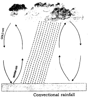
Conceptual Illustration: Picture the sun baking a patch of earth. This intense warmth acts like a giant natural pump, causing the air above to bubble up like water in a boiling pot. As this warm, invisible moisture stream ascends, it encounters cooler atmospheric layers. The invisible vapor then coalesces into vast, puffy clouds that swell upwards. When these sky-borne reservoirs are brimming, they release their contents as often dramatic, yet brief, bursts of rain.
2. Orographic (Relief) Precipitation
Description: This forced ascent leads to adiabatic cooling, initiating the condensation of water vapor and the subsequent formation of clouds on the windward side – the slope directly facing the incoming winds. Consequently, this windward slope experiences substantial and often prolonged rainfall. After surmounting the peak, the now-depleted and drier air descends the opposite slope, compressing and warming as it does so, resulting in a pronounced “rain shadow” effect characterized by significantly drier climatic conditions.
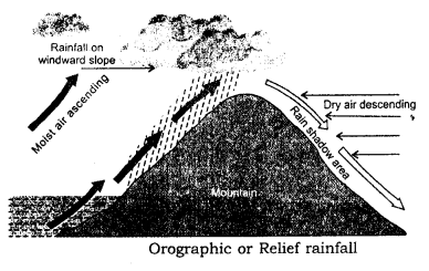
Conceptual Illustration: Imagine a flowing river of moist air being abruptly blocked by a colossal mountain. The air has no recourse but to flow upwards over the formidable peak. As it climbs, it shivers and sheds its moisture, painting the side of the mountain it’s climbing with heavy rain. Once it crests and begins its downward journey on the other side, it’s a “dry sponge,” having released most of its water, creating a parched landscape in the mountain’s lee.
3. Cyclonic (Frontal) Precipitation
Description: Cyclonic or frontal rainfall arises from the convergence of two distinct air masses, each possessing different temperatures and densities. In this interaction, the lighter, warmer, and more humid air mass is dynamically forced to ascend over the denser, colder air mass along their boundary, known as a front. This sustained upward displacement of the warm air triggers cooling and subsequent condensation, leading to the formation of extensive cloud systems. The resulting precipitation is typically widespread and can persist for extended periods, with its intensity influenced by the specific type of frontal interaction (e.g., warm, cold, or occluded front). This rainfall mechanism is a defining characteristic of temperate latitudes, where such air mass collisions are frequent.

Conceptual Illustration: Visualize two colossal weather systems, one warm and laden with moisture, the other cold and weighty, slowly converging. Instead of mixing, the lighter, warm system gently glides upwards over the heavier, cold one, like a ramp. As the warm air gracefully ascends along this invisible ramp, its moisture condenses into broad layers of clouds, casting rain over a considerable expanse of land, a precipitation event that can often endure for hours.
Question 4.
Define precipitation. Write short notes on three forms of precipitation.
Ans:
Understanding Precipitation: Earth’s Water Lifeline
Precipitation is the overarching term for all forms of water, solid or liquid, that falls from the atmosphere to the Earth’s surface. This crucial process begins with water vapor condensing into tiny droplets or ice crystals within clouds. As these grow heavier, gravity pulls them down, making precipitation an indispensable part of the global water cycle, replenishing both surface and underground water sources.
Key Types of Precipitation:
Rain: This is the most common form of liquid precipitation, consisting of individual water droplets descending from clouds. It forms as condensed water vapor aggregates through collisions until droplets are heavy enough to fall.
Snow: It forms when atmospheric water vapor directly freezes into ice within cloud layers at or below freezing temperatures. These individual crystals often interlock to create snowflakes. Snowfall is essential for building mountain snowpacks, which act as natural water reservoirs, slowly releasing water during spring melts. It also plays a significant role in reflecting solar radiation, influencing Earth’s energy balance.
Hail: Hailstones grow within intense, vertically developed thunderstorm clouds. Water droplets are violently carried upwards by strong updrafts into the extremely cold upper atmosphere, where they freeze rapidly. These initial ice pellets can then be repeatedly lifted by updrafts, acquiring more layers of supercooled water that freeze instantly on contact, allowing hailstones to grow to sizes that can cause considerable damage to crops, buildings, and vehicles.
Question 6.
Make a brief survey of the world distribution of rainfall.
Ans:
The world’s rainfall distribution is highly uneven, shaped by a complex interplay of atmospheric circulation, proximity to oceans, topography, and temperature. While the global average annual rainfall is around 100 cm, its spatial variation creates distinct wet and dry regions across the continents.
Generally, the equatorial regions (roughly 10° North to 10° South latitude) experience the heaviest and most consistent rainfall. This is due to intense solar heating, which causes warm, moist air to rise continuously in strong convection currents, leading to frequent thunderstorms and daily precipitation.
Moving poleward, rainfall patterns diverge. In the subtropical regions (around 20° to 35° North and South latitude), particularly on the western sides of continents and within continental interiors, are the world’s major deserts. These arid zones are characterized by descending, dry air associated with high-pressure systems, which inhibit cloud formation and precipitation. Conversely, the eastern coasts of subtropical continents can receive significant rainfall from moist onshore winds and warm ocean currents.
In the mid-latitudes (around 40° to 60° North and South latitude), precipitation is largely influenced by cyclonic storms and frontal systems, which bring moderate to heavy rainfall throughout the year, often with a winter maximum on western coasts due to prevailing westerlies. However, the deep interiors of large continents at these latitudes tend to be drier due to their distance from oceanic moisture sources and extreme temperature variations.
Despite being covered in ice and snow, the extremely cold temperatures mean the air can hold very minimal moisture, resulting in a dry, desert-like climate in terms of actual precipitation amounts, primarily in the form of snow.
Beyond these broad latitudinal belts, mountain ranges play a crucial role, creating significant local variations. Their windward sides receive abundant orographic rainfall as moist air is forced to rise and cool, while their leeward sides often fall into a rain shadow, experiencing arid conditions. Monsoon systems, particularly prominent in South and Southeast Asia, also dictate seasonal patterns of heavy rainfall in specific regions due to dramatic shifts in wind direction bringing vast amounts of oceanic moisture.
