

What are Landforms? The chapter starts by explaining that landforms are the natural shapes or features on the Earth’s surface. It emphasizes that these are formed over long periods by various forces, both from inside the Earth and on its surface.
Major Types of Landforms: It then dives into the main categories of these landforms:
- Mountains: These are highland areas, usually with steep slopes and a peak.. It might touch upon their importance for rivers and climate.
- Plateaus: These are elevated flat-topped lands, often called tablelands. The chapter might mention that they can be young or old and are sometimes very large. Their importance for minerals might be highlighted.
- Plains: The Indo-Gangetic Plains in India are a prime example.
Formation of Landforms: The chapter probably briefly explains the forces that create these landforms:
- Internal Forces (Endogenic): Forces originating from within the Earth, like tectonic movements (leading to folding and faulting that create mountains and plateaus) and volcanic activity (forming volcanic mountains and plateaus).
- External Forces (Exogenic): Forces acting on the Earth’s surface, like weathering (breaking down rocks), erosion (wearing away land by wind, water, and ice), and deposition (laying down of eroded material, forming plains and other features).
Importance of Landforms: The chapter likely touches upon why these different landforms are important to us:
- Mountains are sources of rivers and influence climate.
- Plateaus are often rich in minerals.
- Plains are important for agriculture and human settlements.
EXERCISES
A. Match the columns
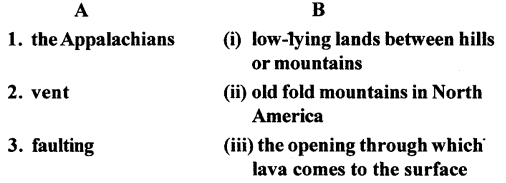
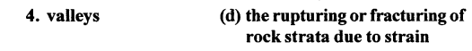
Answer:
B. With the help of your atlas identify and mark the following in an outline map of the world.
Question 1.
An old fold mountain range in India.
Answer:
the Aravalli Range, which is primarily in the northwestern part of India, running roughly southwest to northeast through Rajasthan and extending into parts of Gujarat, Haryana, and Delhi.
Question 2.
A block mountain in Europe
Answer:
The Black Forest of Europe.For identifying a block mountain in Europe on a world outline map, a good example to mark would be the Vosges Mountains in eastern France or the Black Forest in southwestern Germany.You would locate Europe on the map and then mark the general area along the border between France and Germany (for the Vosges) or within southwestern Germany (for the Black Forest).
Question 3.
A storehouse of mineral wealth in eastern india.
Answer:For identifying a storehouse of mineral wealth in eastern India on a world outline map, you would mark the region encompassing the Chotanagpur Plateau.This plateau region, spanning across parts of Jharkhand, Chhattisgarh, Odisha, West Bengal, and Bihar, is well-known for its rich deposits of various minerals like coal, iron ore, mica, bauxite, and other resources.On your outline map of the world, locate eastern India, and then indicate the general area occupied by the Chotanagpur Plateau.
Question 4.
A rift valley in Egypt
Answer:For identifying a rift valley in Egypt on a world outline map, you would mark the area of the Great Rift Valley as it passes through Egypt.
Specifically, the Suez Canal region and the valley extending southwards from it are part of this significant geological feature. The Red Sea itself lies within a rift valley.
On your outline map of the world, locate Egypt in northeastern Africa, and then indicate the general area around the Suez Canal and extending southward along the Red Sea coast as the rift valley.
C. Answer the following questions in brief
Question 1: What are fold mountains? With the help of a neat sketch, briefly explain their formation.
Answer: Fold mountains are those majestic mountain ranges that form when massive pieces of the Earth’s crust, called tectonic plates, collide. The immense pressure from this collision causes the rock layers to crumple and fold upwards, like a tablecloth being pushed from both ends. This folding process creates the towering peaks and valleys we see in these mountain ranges.
(A simple sketch would show two arrows pushing towards each other, with layers of rock in between bending upwards into a wavy, mountainous shape.)
Question 2: State two chief differences between old and young fold mountains. Give examples.
Answer: The main differences lie in their age and appearance. Young fold mountains are relatively recently formed, so they tend to be very tall, with rugged, pointed peaks (like the Himalayas or the Rockies). Old fold mountains, having been around much longer, have been worn down by erosion over millions of years, resulting in lower elevations and rounded peaks (like the Aravallis in India or the Appalachians in the US).
Question 3. What are plateaux? Why are they of great economic value?
Answer:Plateaux are basically elevated flat lands, like high-up table tops. They’re really valuable economically because they often hold rich deposits of minerals like coal and iron. Plus, some plateaus have good grasslands for grazing animals, and others have been developed for generating hydroelectric power from rivers that flow across them.
Question 4. Mention the different types of plateaux.
Answer:You can generally find a few kinds of plateaux: those formed by movements inside the Earth (like tectonic plateaux), those that were once mountains worn down over time (dissected plateau), and those created by volcanic eruptions (volcanic plateaux).
Question 5. What is a basin? Give an example.
Answer: Think of a basin as a large, bowl-shaped area on land that’s lower than the surrounding terrain. Rivers often drain into a central point within a basin. A good example is the Amazon Basin
Question 6. Mention the different types of plains.
Answer:Plains can be formed in a few main ways. There are structural plains, which are large, relatively flat areas that were formed by the uplift of a flat landmass. Then you have depositional plains, built up by the deposition of materials like silt carried by rivers (think of river plains) or by glaciers (glacial plains). Lastly, there are erosional plains, which were once hilly or mountainous but have been worn down over time by erosion.
Question 7. What is the importance of plains?
Answer:Plains are super important because their flat land and often fertile soil make them great for farming and growing food. This also means they can support large populations, so you often find major cities and settlements in these areas. Plus, they’re usually easier to build roads and railways on, making transportation and trade easier.
Question 8. What is a peninsula? Take the help of your atlas and name four major peninsulas of the world.
Answer:A peninsula is basically a piece of land that sticks out into a body of water but is still connected to the mainland on one side. Think of it as almost an island, but not quite! Four major peninsulas around the world are the Arabian Peninsula, the Indian Peninsula, the Scandinavian Peninsula, and the Iberian Peninsula.
D. Answer the following questions in one or two paragraphs :
Question 1. Name the major landforms on Earth.
Answer:The big shapes we see on our planet are mainly mountains, which are high and often pointy; plateaus, which are high but flat on top like a table; and plains, which are large, mostly flat areas.
Question 2. List the continents according to size. Describe the two largest continents in detail.
Answer:The continents, from biggest to smallest, are generally: Asia, Africa, North America, South America, Antarctica, Europe, and Australia.
Asia, the largest, is a vast landmass with the highest mountains (like the Himalayas), huge deserts (like the Gobi), and a massive variety of climates and cultures. It’s home to the world’s most populous countries.
Africa, the second largest, is known for its diverse wildlife, extensive savannas, and significant geographical features like the Sahara Desert and the Nile River.
Question 3. Write short notes on Europe and Australia.
Answer:Europe is a relatively small but densely populated continent known for its diverse countries, rich history, and influential cultures. It’s characterized by varied landscapes, from mountains and forests to coastlines, and has played a major role in global events.
Australia, the smallest continent and also a country, is an island nation with unique flora and fauna, including marsupials like kangaroos and koalas. It has diverse landscapes, from deserts and grasslands to tropical rainforests and the Great Barrier Reef
Question 4. How is Mount Fuji in Japan different from the Vosges of Europe?
Answer:Mount Fuji stands tall as a classic volcanic mountain, formed by eruptions of lava and ash, giving it a cone shape. The Vosges, on the other hand, are a block mountain range, created when large blocks of the Earth’s crust were pushed up or dropped down along fault lines. So, their origins and overall shapes are quite different.
Question 5. Briefly describe the importance of mountains.
Answer:Mountains are incredibly vital. They act as natural water towers, feeding rivers that supply water for drinking and irrigation. They also influence climate, creating different weather patterns. Plus, they’re biodiversity hotspots and offer stunning landscapes for recreation.
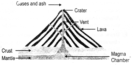
Question 6. How is a volcanic mountain formed?
Answer:A volcanic mountain is born from the Earth’s fiery interior. When molten rock, called magma , erupts through weaknesses in the Earth’s crust, it cools and solidifies layer upon layer. Over time, these accumulated layers build up to form the characteristic cone shape of a volcanic mountain.
Question 7. What is a V-shaped valley?
Answer:A V-shaped valley is a valley with steeply sloping sides that come together at a narrow bottom, resembling the letter “V.” It’s primarily carved out by the erosive power of a flowing river or stream over time, as the water cuts down through the rock.
Question 8.
Briefly explain
- peninsula
- island
- isthmus.
Answer:
1. Peninsula
A peninsula is a piece of land that is surrounded by water on three sides but is connected to a larger landmass on one side.
- Key Feature: It “juts out” into the sea or ocean.
- Example: India is a great example (often called the Indian Peninsula) because it is surrounded by the Arabian Sea to the west, the Bay of Bengal to the east, and the Indian Ocean to the south.
2. Island
An island is a piece of land that is completely surrounded by water on all sides.
- Key Feature: It is smaller than a continent and has no land connection to other landmasses.
- Example: Sri Lanka, the Andaman and Nicobar Islands, or Greenland. A group of islands located close together is called an archipelago.
3. Isthmus
An isthmus is a very narrow strip of land that connects two much larger landmasses and has water on both sides.
- Key Feature: It acts like a “bridge” between two continents or large pieces of land.
- Example: The Isthmus of Panama, which connects North America and South America, and the Isthmus of Suez, which connects Africa and Asia.
E. Draw neat, labelled, coloured sketches to show the characteristics of each of the following geographical features. Write a brief description alongside, explaining each of them
Question 1.
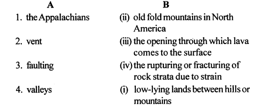
Block mountain
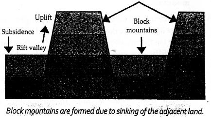
Answer: a block mountain as a chunk of the Earth’s crust that has been pushed upward by powerful forces inside the Earth, often along cracks called faults. It typically has steep sides and a relatively flat top. Think of it like a raised platform or a table that’s been lifted. These mountains often form in groups and with valleys (called grabens) sinking down in between the raised blocks.
Question 2.
Volcanic mountain
Answer: a volcanic mountain as a cone-shaped landform built up from layers of hardened lava, ash, and other materials erupted from beneath the Earth’s surface through a vent. 1 It often has a crater at the top is the opening of the volcano. 2 These mountains can range in size from small hills to towering peaks and are formed by the Earth’s internal heat and pressure
Question 3.
Plateau
Answer:a plateau as a big, flat area of land that’s way up high, almost like a raised table sticking out from the lower ground. It’s essentially a large, elevated plain formed by different natural processes.”
Question 4.
Rift valley
Answer: a rift valley as a long, narrow depression on the Earth’s surface that forms when the ground sinks down between parallel cracks or faults in the Earth’s crust. 1 It’s like a trough or a valley with relatively steep sides. These valleys are often associated with volcanic activity and earthquakes.
Question 2.
Why are river plains thickly populated ?
Answer:“Basically, a plain is a big, flat stretch of land that’s pretty level. A plateau, on the other hand, is also a large area, but it’s up high and flat on top, with steep drops on the sides – think of it like a raised table.”Question 2. Why are river plains thickly populated?
River plains tend to have fertile soil, thanks to the river depositing silt. They also provide easy access to water for agriculture, drinking, and transportation. The flat land makes it easier to build settlements and infrastructure, leading to dense populations.
Question 3. How is life in the plains different from life in the mountains?
Answer:Life in the plains is often centered around agriculture and larger settlements. The flat terrain makes transportation and construction easier. In contrast, life in the mountains is often more challenging due to the rugged terrain, which can limit agriculture and transportation. Mountain communities may be more isolated and have different cultural adaptations to the environment.
