

First up are the oceans, the biggest water bodies out there, covering most of the Earth. You’ll probably learn the names of the big five (Pacific, Atlantic, Indian, Arctic, and Antarctic/Southern) and why they’re important for weather and all the creatures living in them.
Then come the seas, which are like smaller versions of oceans, often tucked in a bit by land but still connected to the big ones. You might hear about some important seas like the Arabian Sea or the Mediterranean.
Next are rivers, those natural flowing streams of mostly freshwater that eventually head towards an ocean, sea, lake, or another river. The chapter likely talks about how important they are for things like drinking water, watering crops, getting around, and even making good farmland. You might even learn about some famous rivers around the world and in India.
After that, it’s all about lakes, which are big pools of still water surrounded by land. The chapter will probably explain why they’re important too.
And let’s not forget glaciers, those huge, slow-moving chunks of ice that build up from lots of snow. You’ll likely learn that they’re a big source of freshwater when they melt and that they can even change the shape of the land over time.
Finally, the chapter wraps up by talking about why all these major water bodies are so important for life on Earth, how they affect our weather, what resources we get from them, and how they help us travel. It might even touch on how all the water is connected through the water cycle.
EXERCISES
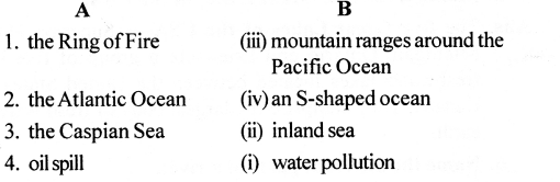
A. Match the columns
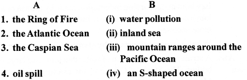
Answer:
B. With the help of your atlas identify and mark the following in an outline map of the world.
Question 1. The largest ocean in the world:
Answer: That would be the mighty Pacific Ocean. It’s absolutely huge, stretching all the way from the Americas to Asia and Australia. You’d mark a vast area covering much of the globe’s surface between these continents.
Question 2. The northernmost ocean:
Answer:That’s the Arctic Ocean. It’s the smallest and coldest of the oceans, mostly covered in ice for much of the year. You’d mark the icy waters at the very top of the world map.
Question 3. An inland sea in Eurasia:
Answer:A good example here is the Caspian Sea. Despite its name, it’s actually a huge, landlocked body of saltwater nestled between Europe and Asia. You’d find it east of Europe and west of Central Asia on the map.
Question 4. Two rivers in Europe:
Answer:For this, you could mark a couple of well-known European rivers. The Rhine River flows through several countries in Western Europe, including Germany, France, and the Netherlands, eventually reaching the North Sea. The Danube River is another major one, winding its way through Central and Eastern Europe, passing through cities like Vienna and Budapest before emptying into the Black Sea. You’d trace their paths across the European continent on your map.
c. Answer the following questions in brief
Question 1. Name the major water bodies on Earth.
Answer:We’re talking about the big players like the five oceans – the Pacific, Atlantic, Indian, Arctic, and the one around Antarctica. Then you’ve got seas, which are like smaller parts of the oceans, plus the flowing rivers, the still lakes, and those massive ice rivers we call glaciers.
Question 2. What is the Ring of Fire?
Answer:Think of the Ring of Fire as a really active zone circling the Pacific Ocean. It’s a hotspot for earthquakes and volcanoes because all the Earth’s big plates are bumping and grinding against each other down there.
Question 3. What is the difference between a gulf and a bay?
Answer:
| Feature | Gulf | Bay |
| Size | Generally larger and deeper. | Generally smaller and shallower. |
| Shape | Has a narrow mouth and is almost completely enclosed by land. | Has a wide, open mouth with a more inward-curving shape. |
| Formation | Formed mainly due to tectonic movements (shifting of the Earth’s crust). | Formed mainly by water erosion washing away soft rocks. |
| Water Movement | Waters are usually calmer because the narrow opening protects it from the open ocean. | Waters can be more turbulent as the wide opening allows more ocean waves in. |
| Examples | Gulf of Mexico, Persian Gulf, Gulf of Kutch. | Bay of Bengal, Hudson Bay, Bay of Biscay. |
Question 4. Mention the five Great Lakes of the USA.
Answer:The five really big lakes in the USA (though a few share a border with Canada!) are Lake Superior, Lake Michigan, Lake Huron, Lake Erie, and Lake Ontario. A neat trick to remember them is the word “HOMES.”
Question 5. Name the different parts of a river.
Answer:A river usually has a few key stages. It starts at its source often high up in the mountains or from a spring. Then it follows its course, which can be split into the upper, middle, and lower sections as it flows along. Finally, it reaches its mouth, where it empties into another body of water, like a lake, a sea, or the ocean.
Question 6. What is surface run-off?
Answer: In short, surface run-off is the portion of rainwater (or snowmelt) that does not soak into the ground but instead flows over the surface of the land.
It occurs when the rain falls faster than the soil can absorb it, or when the ground is made of hard, non-porous materials like rock or concrete.
How it Works
Collection: It eventually gathers into small streams, which then flow into larger rivers, lakes, or the ocean..
Saturation: When the ground becomes like a soaked sponge and can’t hold more water, or when the surface is “impermeable” (like a road), the water stays on top.
Gravity: Due to the slope of the land, this excess water flows downhill.
D. Answer the following questions in one or two paragraphs
Question 1. Why are oceans important?
Answer:“Oceans are truly essential for Earth! Covering most of its surface, they’re key in keeping our climate stable by soaking up and releasing heat gradually. They also teem with amazing life, creating intricate ecosystems that are super important for the planet’s well-being. On top of that, we rely on oceans for food, resources, and as major pathways for ships carrying goods and people.”
Question 2. Describe the course of a river.
Answer:A river typically starts in a highland area, like mountains or hills, as a small stream or spring – this is its source. As it flows downhill, gravity pulls it along, and it often gathers water from other small streams called tributaries. In its upper course, the river tends to be fast-flowing and erodes the land, often creating valleys and waterfalls. In the middle course, the river usually widens and slows down a bit as the land becomes less steep, starting to deposit some of the eroded material and sometimes forming meanders (bends). Finally, in its lower course, the river flows across flatter land, becomes wider and slower, deposits more silt, and eventually reaches its mouth, where it empties into a larger body of water like an ocean, sea and lake, sometimes forming a delta.
Question 3. Mention any five important rivers of the world.
Answer:Here are five really important rivers from different parts of the world: There’s the Amazon in South America, famous for carrying a huge amount of water. Then you’ve got the Nile in Africa, super long and historically vital for Egypt. In Asia, the Yangtze is a big deal in China, used a lot for getting around and watering crops. North America has the Mississippi, a major waterway for the US. And finally, there’s the Ganges in South Asia, which is really sacred in India and important for farming.
Question 4. Briefly describe the importance of rivers.
Answer:Rivers are incredibly important for so many reasons! They provide us with essential freshwater for drinking and irrigation, making agriculture possible. Historically, they’ve been crucial for transportation and trade, allowing civilizations to develop and connect. Rivers also support diverse ecosystems and are vital habitats for countless plants or animals. Furthermore, they can generate hydroelectric power and play a significant role in shaping the landscape through erosion and deposition.
Question 5. What are the major causes of water pollution?
Answer:Industrial waste containing harmful chemicals is often discharged directly into rivers and lakes. Sewage and wastewater from homes and cities can introduce bacteria or other pollutants. Agricultural runoff carries fertilizers or pesticides into water bodies. Oil spills from ships and offshore drilling contaminate marine environments. Even litter and plastic waste that end up in water sources contribute significantly to the problem.
Question 6. What is an oil spill? Why is it harmful for the environment?
Answer:An oil spill happens when liquid oil, the kind we get from the ground, gets released into the environment, and this unfortunately occurs quite often in our oceans and seas.”. This can happen due to accidents involving oil tankers, offshore drilling platforms, or pipelines. Oil spills are extremely harmful because they can smother marine animals and seabirds, coat their feathers or fur, making it impossible for them to regulate their body temperature or move properly, often leading to death. Oil can also contaminate water and food sources for marine life, disrupt entire ecosystems, and take a very long time to break down, causing long-lasting damage to the environment.
E. Picture study:

Look at the picture of an ocean given here and answer the questions.
Question 1.
Describe the characteristics of the largest ocean in the world.
Answer: Its sheer size is remarkable, capable of encompassing all the Earth’s landmasses. It also plunges to incredible depths, exemplified by the Mariana Trench. This vast expanse supports an extraordinary variety of marine life, including everything from plankton to massive whales, alongside vibrant coral ecosystems. Furthermore, the Pacific basin is largely bordered by the Ring of Fire, a region known for significant seismic and volcanic activity.
Question 2.
What are the differences between an ocean and a sea ?
Answer:
| Feature | Ocean | Sea |
| Size | Enormous bodies of saltwater that cover 71% of Earth. | Much smaller than oceans. |
| Depth | Significantly deeper (average depth is about 3.7 km). | Shallower; usually located where the land meets the ocean. |
| Land Boundaries | Not bounded by land; they separate continents. | Usually partially enclosed by land. |
| Number | There are only 5 (Pacific, Atlantic, Indian, Southern, Arctic). | There are dozens (e.g., Mediterranean, Red, Caribbean). |
| Marine Life | Home to deep-sea creatures and massive mammals. | Higher biodiversity due to proximity to sunlight and land. |
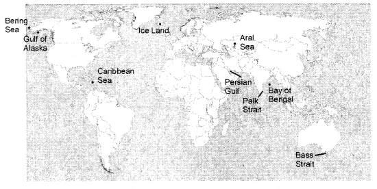
F. On a blank outline map of the world, mark and label the following.
Gulf of Alaska, Caribbean Sea, palk Strait, Bay of Bengal, Bering Sea, Perisan Gulf, Bass Strait, Iceland, Aral Sea
Answer:
Let’s Do Something
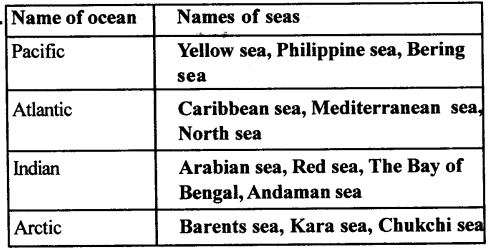
Question 1.
Refer to your atlas and identify some of the important seas in each ocean. Tabulate your observations as shown here and then mark and label them on a blank outline map of the world.
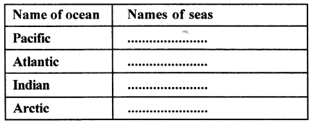
Answer:
