

North America, the third-largest continent, is located completely in the Northern Hemisphere and for the most part in the Western Hemisphere.
Where it’s situated: It stretches from the Arctic Ocean down south to the Isthmus of Panama, its land bridge to South America. The Atlantic Ocean borders it to the east, and the Pacific Ocean to the west.
Its size: This massive landmass covers about 24.7 million square kilometers.
Countries and regions: The three main independent nations are Canada (the second-largest country by land area), the United States (a significant global power), and Mexico (rich in history and culture). Additionally, there are smaller countries in Central America and the Caribbean, along with territories belonging to other nations, such as Greenland (part of Denmark).
Its physical features: North America boasts a diverse landscape, primarily divided into four regions:
- The Western Cordillera: A vast mountain system along the western edge, featuring the towering Rocky Mountains, the Sierra Nevada, and the Coast Mountains, characterized by high peaks, deep valleys, and volcanic activity.
- The Central Lowlands: Expansive, relatively flat plains nestled between the western mountains and the eastern highlands. This fertile region is drained by major rivers like the Mississippi and Missouri and is home to the Great Lakes, a collection of large freshwater lakes.
- The Eastern Highlands: An older, more eroded mountain range along the eastern side, including the Appalachian Mountains, which are lower and more rounded compared to the Rockies.
- The Coastal Plains: Relatively flat areas bordering the Atlantic Ocean and the Gulf of Mexico in the east, and the Pacific Ocean in the west. The Atlantic Coastal Plain is wider and includes features like the Outer Banks.
EXERCISES
A. Fill in the blanks
- A narrow stretch of land that joins North America to South America and separates the Atlantic Ocean from the Pacific Ocean : ————
Ans : The Isthmus of Panama.
- The tropical islands, called the West Indies, are located in this sea :———-.
Ans : Caribbean Sea
- Physical division of North America around the Hudson Bay which has the oldest known hard rocks of the world :—————.
Ans : The Canadian Shield
- A river that flows northwards and drains into the Hudson Bay :————-.
Ans : River Mackenzie and River Nelson
B. Identify who I am.
- I am a city in North America which is a symbol of unity, history, and democracy : Washington DG.
- I am an island at the entrance of river Hudson where the famous Statue of Liberty is situated : Liberty Island.
- I am from a city which is world famous for its film industry : Los Angeles.
- I am the city which has the Rideau Canal : Ottawa
- I am the city of Canada which was once the world’s leading grain port : Montreal
C. Give geographical reasons why
Question 1.
The 49° N latitude and the 100°W longitude are important for North America.
Answer:The 49th parallel is a key line that forms much of the border between Canada and the US. The 100th meridian acts like a natural split across North America, with wetter areas usually to its east and drier areas to its west.
Question 2.
The Western Cordilleras form part of the ‘Pacific Ring of Fire’.
Answer:The Western Cordilleras form part of the ‘Pacific Ring of Fire’. Answer: Yes, the Western Cordilleras are right on the Pacific’s edge where tectonic plates bump into each other, causing lots of volcanic and earthquake activity – that’s the “Ring of Fire” in action.
Question 3. The Appalachians appear as low hills today.
Answer: True. Time and natural forces have worn these old mountains down to gentler hills.
Question 4. Lumbering is traditionally done in the winter season.
Answer: True. Back in the day, winter’s frozen ground made hauling logs simpler, and farmers had more time for logging.
D. Answer the following questions in brief
Question 1.
Name the Italian explorer who reached North America in 1507 CE.
Answer:
Amerigo Vespucci.
Question 2.
Name some of the islands that are collectively called the West Indies.
Answer:The West Indies is a group of islands that includes places like Jamaica, Cuba, Hispaniola (home to Haiti and the Dominican Republic), Puerto Rico, Barbados, and the Bahamas.
Question 3.
Why is New York an important city in the USA ?
Answer:New York City holds a key position in the USA as a major center for finance, culture, fashion, and global connections. It’s a vital worldwide hub for business and a lively place with many different cultures and new ideas.
Question 4.
Where are the Great Lakes situated ? Which river drains these lakes into the Atlantic Ocean ?
Answer:The Great Lakes are located in North America, along the border of Canada and the United States. Their water flows out into the Atlantic Ocean through the St. Lawrence River.
Question 5.
Write about the largest river system of North America.
Answer:North America’s biggest river setup? That’d be the Mississippi River System. It’s a massive web with the Mississippi, Missouri, and Ohio Rivers all working together. This giant drains land from the Rockies to the Appalachians before flowing out into the Gulf of Mexico.
Question 6.
Where is the Grand Canyon situated ? Why is it so famous?
Answer:you’ll find the Grand Canyon in Arizona, USA. It’s a total knockout with its massive size, crazy depth, and those bright rock layers showing off millions of years of Earth’s story. Seriously breathtaking, and the views bring in tons of people every year.
D. Answer the following questions in one or two paragraphs
Question 1.
List the four major physical divisions of North America. Describe any one of them briefly.
Answer:you’ve painted a great picture of this central region. It’s truly the breadbasket of North America, isn’t it? That immense flatness, those rich soils fed by the great rivers – it’s what makes it such a powerhouse for farming. And you’re spot on about the energy resources tucked beneath the surface too.
Question 2.
Why is the Canadian Shield region full of lakes ? Name any three lakes other than the five Great Lakes.
Answer:Canada has countless lakes, especially across the Canadian Shield. This is mainly because huge glaciers dug out hollows in the land. When these glaciers melted and went away, water filled these dips, creating lakes. The Shield’s rough and uneven surface also helps trap water naturally. Besides the famous Great Lakes, Canada also has big lakes like Great Bear Lake, Great Slave Lake, and Lake Winnipeg.
Question 3.
What are the various categories of lumberjacks ? What kind of work do they do ?
Answer:Lumberjacks, also known as loggers, have various roles in the timber harvesting process. Historically, these roles were more distinct, often involving manual labor, but modern logging involves specialized jobs and machinery. Here are some categories and their work:
- Fallers: These workers are responsible for cutting down trees. They assess the direction of the fall and use chainsaws or felling machinery to safely bring trees down.
- Buckers: They trim the tops and branches off felled trees and cut the trunks into logs of specific lengths.
- Skidders/Forwarder Operators: They operate heavy machinery like skidders or forwarders to drag or carry logs from the cutting site to a landing area.
- Log Loaders: These operators use specialized machinery to lift and load logs onto trucks for transportation.
- Choker Setters: They attach cables (chokers) around logs so they can be dragged by skidders or other equipment.
- Rigging Slingers and Chasers: In cable logging operations, they set up and dismantle the cables and rigging used to move logs, often on steep terrain.
- Log Sorters, Markers, Movers, and Chippers: These workers sort logs based on species, size, and quality, mark them, move them, and sometimes operate machinery that chips the logs.
- Logging Equipment Operators: They operate various machines like tree harvesters (feller bunchers) that can fell, delimb, and cut trees into logs.
- Haulers/Truck Drivers: They transport the logs from the landing areas to sawmills or other processing facilities.
These categories reflect the division of labor in logging, ensuring efficiency and safety in the process of harvesting timber.
Question 4.
Describe how the lives and work of lumberjacks have changed in modern times.
Answer:The life and work of lumberjacks have undergone a dramatic transformation in modern times.
From Manual Labor to Mechanization:
Past: Lumberjacks relied heavily on manual tools like axes and crosscut saws, demanding immense physical strength and endurance.
Present: Modern logging is highly mechanized. Powerful machinery like feller bunchers, harvesters, and skidders now perform tasks such as felling, delimbing, and moving trees with speed and efficiency. This has significantly reduced the physical demands and dangers of the job.
Changes in Lifestyle:
Life for lumberjacks in the past meant long stretches in isolated, temporary camps, a world away from their loved ones and familiar places.
Present: With improved transportation and infrastructure, most modern forestry workers can live in established communities and commute to work sites daily. This allows for a more stable family life.
Technological Advancements:
Present: Communication on job sites is enhanced through mobile technology.
Focus on Sustainability:
Present: There’s an increasing emphasis on sustainable forestry practices. Modern lumberjacks and forestry companies are involved in reforestation efforts, selective logging, and minimizing environmental impact, a stark contrast to some historical practices.
In essence, the romanticized image of the burly lumberjack wielding an axe has largely been replaced by skilled machine operators and technicians who utilize advanced technology for efficient and sustainable wood harvesting. While the core task of harvesting trees remains, the tools, techniques, and lifestyles associated with the profession have been revolutionized
F. Picture study
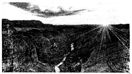
This is a photograph of the Grand Canyon in Arizona.
Question 1.
Why do you think this canyon is called ‘Grand’ ?
Answer:it’s called “Grand” because it’s unbelievably huge – super long, wide, and deep. Plus, the way the rocks look, all those layers and colors carved out over ages, is just amazing. And when you see it in person, especially with the sun coming up or going down like in the picture, it’s simply breathtaking. It just feels grand, you know?
Question 2.
Name the river that has carved out the Grand Canyon.
Answer:Grand” feels like an understatement! It’s not just big; it’s unbelievably huge. You can barely wrap your head around the sheer distance and depth of it. And then there’s the beauty – those layers of rock with all their amazing colors, the way the light plays across the vastness… it’s just stunning. Knowing that the mighty Colorado River patiently carved this masterpiece over millions and millions of years just adds to the feeling that it’s something truly special, something truly grand.
