
 (1280 x 720 px) (15)")
Earthquakes manifest as abrupt shaking of the Earth’s surface, stemming from the sudden discharge of accumulated energy within the crust, which then radiates outwards as seismic waves. These powerful events are primarily instigated by the shifting and interaction of Earth’s massive tectonic plates along geological fault lines, leading to immense pressure accumulation and subsequent forceful release. While plate dynamics are the predominant trigger, other contributing factors can include volcanic unrest, slippages along existing faults, and even human interventions like the construction of large dams or underground detonations. The point deep within the Earth where an earthquake originates is termed the focus or hypocenter, with the epicenter being the corresponding spot directly above it on the surface, typically experiencing the most intense shaking and damage.
The energy from an earthquake propagates through distinct seismic waves: P-waves (primary) are the fastest, moving with a pushing-pulling motion through any medium; S-waves (secondary) are slower, exhibiting a side-to-side motion, and can only traverse solids; while L-waves (surface waves) are the slowest but frequently inflict the most substantial damage as they travel along the Earth’s surface. Seismographs are instruments designed to detect and record these vibrations. An earthquake’s magnitude, or the energy it releases, is quantitatively assessed using the logarithmic Richter Scale, whereas its intensity, based on observed impacts and destruction, is qualitatively determined by the Mercalli Scale. These geological events are predominantly found along tectonic plate boundaries, such as the Circum-Pacific Belt. Mitigating the risks involves constructing resilient buildings, avoiding construction in high-vulnerability zones, and fostering public awareness and preparedness.
Exercises
I. Fill in the blanks below
1. Most earthquakes occur on account of the strain in the ______________ .
Ans: earth’s crust.
2. ______________ are the first earthquake waves to be recorded on a seismograph of an earthquake.
Ans: P (primary or push waves)
3. The last of the earthquake waves to arrive on the surface of the earth are ________________ waves.
Ans: L (surface or long)
4. The giant sea waves caused by earthquakes in the oceans are called _____________ .
Ans: Tsunamis.
5. About 70 per cent of the earthquakes occur in the ____________________________ Belt.
Ans: Circum- Pacific-Mountain
II. Short Answer Questions
Question 1.
What is called an earthquake ?
Ans:
An earthquake is a sudden and often violent shaking or trembling of the Earth’s surface. This phenomenon occurs when there’s an abrupt release of accumulated stress within the Earth’s crust or upper mantle. This released energy then propagates outwards in the form of seismic waves, causing the ground to move and often leading to significant damage.
In simpler terms, imagine the Earth’s crust as a giant, broken puzzle. When these “puzzle pieces” (tectonic plates) move past, into, or away from each other, immense pressure builds up. Eventually, this pressure becomes too great, and the rock on either side of a fault line (a crack in the Earth’s crust) suddenly slips and breaks. This sudden rupture and release of energy is what we perceive as an earthquake.
Question 2.
State two natural causes of an earthquake.
Ans:
Here are two natural causes of an earthquake, explained uniquely and without plagiarism:
- Tectonic Plate Movement: The Earth’s outermost layer, the lithosphere, is broken into several large and small pieces called tectonic plates. These plates are constantly, albeit slowly, moving due to convection currents in the Earth’s mantle beneath them. When these plates slide past each other, collide, or pull apart, immense stress builds up along their boundaries (fault lines). Eventually, this accumulated stress exceeds the strength of the rocks, causing them to suddenly fracture and slip. This abrupt release of energy propagates as seismic waves, resulting in an earthquake.
- Volcanic Activity: Earthquakes can also occur in conjunction with volcanic eruptions or the movement of magma (molten rock) beneath the Earth’s surface. As magma rises and flows through cracks and conduits within the Earth’s crust, it can exert pressure on the surrounding rock. This pressure can cause the rock to fracture, leading to tremors. More forceful volcanic eruptions can also create significant ground vibrations that register as earthquakes. These are often localized and shallower than tectonic earthquakes.
Question 3.
Name one man-made cause of an earthquake.
Ans:
One man-made cause of an earthquake is reservoir-induced seismicity.
This occurs when the immense weight of water collected in large reservoirs, typically behind newly constructed dams, exerts pressure on the underlying rock formations. This added pressure can reactivate pre-existing fault lines or create new stresses, leading to tremors or even significant earthquakes in areas that were previously seismically inactive or less active.
Question 4.
What are known as seismic focus and epiceptre with respect to an earthquake ?
Ans:
In the context of an earthquake, “seismic focus” and “epicenter” are two crucial terms that pinpoint its origin:
- Seismic Focus (or Hypocenter): This refers to the exact point within the Earth’s crust or upper mantle where an earthquake originates. It’s the location deep underground where the stored elastic energy is first released due to the sudden rupture or slippage along a fault line. All the seismic waves generated by the earthquake propagate outwards from this specific point.
- Epicenter: The epicenter is the point on the Earth’s surface directly above the seismic focus. Because it’s the closest point on the surface to the earthquake’s origin, the epicenter typically experiences the most intense shaking and the greatest amount of damage.
Question 5.
What is known as the Richter scale ? State its uses.
Ans:
The Richter scale, developed by Charles F. Richter in 1935, is a numerical, base-10 logarithmic scale that quantifies the magnitude of an earthquake. This means each whole number increase signifies a tenfold rise in the amplitude of seismic waves recorded and approximately 31.6 times more energy released. Primarily, it’s used to:
- Standardize Earthquake Size: Provide a consistent measure for comparing the inherent strength of different seismic events.
- Inform Public and Media: Offer a quick, understandable metric for the general public and news outlets to grasp an earthquake’s intensity.
- Guide Emergency Response: Although not directly predicting damage, the magnitude helps emergency services anticipate the potential scale of a disaster and allocate resources effectively.
- Support Scientific Research: Aid seismologists in mapping seismic activity, studying Earth’s internal structure, and developing hazard assessments, influencing earthquake-resistant design.
Question 6.
How are earthquakes useful ?
Ans:
Here’s a unique take on the provided text, focusing on the beneficial aspects of earthquakes:
Earthquakes: Unsung Architects of Our Planet
They function as critical pressure regulators, systematically releasing the colossal stresses that continuously accumulate from the relentless motion of tectonic plates. Without these periodic energy discharges, the pent-up tension could escalate, potentially culminating in infrequent but exponentially more devastating geological occurrences.
Over geological epochs, earthquakes emerge as profound sculptors of the terrestrial landscape. They are indispensable for orogenesis, the grand process responsible for the dramatic elevation of mountain ranges like the formidable Himalayas. Furthermore, their powerful shifts etch out distinctive features such as fault-block mountains and the expansive depressions of rift valleys, fundamentally reconfiguring the continental crust. The dynamic ground movements can also give rise to novel aquatic bodies or depressions and reshape coastal contours, leading to the emergence of new bays or the exposure of previously submerged land, occasionally fostering new ecological niches.
Of immense scientific value, earthquakes provide an unparalleled window into Earth’s enigmatic interior. Through meticulous analysis of how seismic waves propagate and refract through various subterranean layers, scientists can precisely map the planet’s internal architecture—from its outermost crust to its deepest core—unveiling its intricate composition and physical properties. This indirect yet profoundly significant contribution to our comprehension of Earth’s inner workings is absolutely indispensable.
Lastly, although not direct creators, the geological processes set in motion by seismic activity play a pivotal long-term role in the concentration of natural resources. Over millions of years, the intense heat and pressure prevalent in geologically active zones contribute significantly to the genesis and localization of valuable mineral deposits, enriching the Earth’s accessible reserves.
Question 7.
Give any two destructive effects of earthquakes ?
Ans:
Here are two destructive effects of earthquakes:
- Collapse of Structures and Infrastructure: The violent shaking of the ground during an earthquake can cause buildings, bridges, roads, and other essential infrastructure to crack, crumble, and completely collapse. This leads to widespread destruction, trapping people, causing injuries, and disrupting essential services like transportation and communication. The severity of collapse depends on the earthquake’s magnitude, the proximity to the epicenter, and the structural integrity of the affected constructions.
- Triggering of Secondary Hazards: Earthquakes often unleash a cascade of subsequent destructive events. For instance, underwater earthquakes can displace vast amounts of water, generating colossal tsunamis that travel across oceans and devastate coastal areas with immense waves. On land, the intense vibrations can destabilize slopes, leading to massive landslides and avalanches that bury communities, block roads, and destroy natural habitats.
Question 8.
What is a tsunami ? How is it caused ?
Ans:
Tsunamis: Unveiling the “Harbor Wave”
Tsunamis, a phenomenon distinct from regular tides and famously termed “harbor waves” in Japanese, are colossal ocean waves generated by the sudden and significant displacement of a massive volume of seawater.
The most prevalent catalyst for devastating tsunamis is underwater earthquakes, specifically thrust earthquakes. In these events, an abrupt vertical shift in the ocean floor effectively elevates or depresses the colossal water column above it. This sudden geological upheaval releases immense energy, which then propagates outwards as powerful, long-wavelength waves.
Beyond seismic tremors, other less common but potent triggers for tsunamis include:
- Submarine landslides: Often themselves a consequence of seismic or volcanic activity, these events violently dislodge large quantities of water.
- Intense volcanic eruptions: Particularly those occurring beneath the ocean or involving substantial collapses of volcanic material into the sea, can instigate tsunamis.
- Meteorite impacts: While exceedingly rare, a meteorite striking the ocean could theoretically induce an immediate and enormous water displacement, leading to a tsunami.
The life cycle of a tsunami unfolds in several phases:
- Origination: The initial, rapid disruption of the water body creates an immediate surface disturbance.
- Transoceanic Travel: In the deep ocean, these waves possess remarkable wavelengths but maintain a low profile, often less than a meter high. Despite their inconspicuous appearance, they hurtle across vast expanses of ocean at speeds comparable to a jet aircraft (up to 800 km/h), rendering them virtually undetectable to vessels.
- Coastal Amplification: As a tsunami nears the shoreline and encounters progressively shallower waters, friction with the rising seabed dramatically decelerates its progression. Crucially, the wave’s inherent energy is preserved, resulting in a pronounced increase in its height. This “stacking” effect transforms the previously imperceptible wave into an imposing wall of water or a rapidly advancing surge.
- Shoreline Impact: Upon reaching the coast, these amplified waves unleash their destructive force, inundating extensive stretches of land. A tsunami is rarely a singular event; instead, it typically manifests as a sequence of waves, with subsequent waves often proving more destructive. A perilous precursor can be the sudden and significant withdrawal of water from the shoreline, which can tragically pull debris and unaware individuals out to sea.
Question 9.
How do Japanese predict earthquakes ?
Ans:
Japan, a global leader in seismic technology, prioritizes earthquake early warning (EEW) over impossible long-term prediction. Their system, managed by the Japan Meteorological Agency (JMA), leverages a dense network of over 4,000 seismometers to detect the faster, less destructive P-waves immediately after an earthquake begins.
Within seconds, JMA’s advanced computers analyze this data to pinpoint the epicenter, depth, and magnitude. If significant shaking (M5+ or Japan Seismic Intensity Scale 4+) is anticipated in populated areas, an instant warning is issued via TV, radio, mobile networks, and public address systems. This “grace period”—from seconds to over a minute—allows critical automated responses, like Shinkansen braking, factory shutdowns, and elevator halts, and gives people vital time to seek cover, minimizing damage and saving lives.
While precise prediction remains unattainable, Japanese scientists continuously research precursor phenomena like crustal deformation (using GPS and GNSS-A), subtle seismic activity changes, and other geophysical shifts, aiming to further enhance their already sophisticated seismic preparedness.
Question 10.
Name the two belts where most of the earthquakes occur.
Ans:
The bulk of the world’s earthquake occurrences are concentrated within two primary geological regions:
The Circum-Pacific Belt, often referred to as the “Pacific Ring of Fire,” is an exceptionally active seismic zone responsible for approximately 80% of all major earthquakes worldwide. This dynamic area traces the perimeter of the Pacific Ocean, encompassing the coastlines of countries such as New Zealand, Indonesia, the Philippines, and Japan, extending through the Aleutian Islands and Alaska, and continuing down the western edges of both North and South America. Its high seismic activity is primarily attributed to numerous subduction zones, where dense oceanic tectonic plates are forcefully driven beneath lighter continental plates, leading to significant geological instability.
The Mid-World Mountain Belt, also known as the Alpine-Himalayan Orogenic Belt, is another significant seismic region. It extends from the Mediterranean Sea, traverses the imposing Himalayan mountain range, and reaches into parts of Southeast Asia. This belt is the origin point for about 15% of the planet’s major earthquakes. The seismic activity here is a direct consequence of the immense compressional forces generated by the ongoing collision between the African, Arabian, and Indian tectonic plates with the Eurasian plate, a process that has shaped vast mountain systems and continues to fuel seismic events.
III. Match the following
Ans:
IV. Long Answer Questions
Question 1.
Describe how earthquakes are caused on the surface of the earth.
Ans:
Earthquakes primarily result from the movement of Earth’s tectonic plates. These massive sections of the lithosphere are constantly shifting due to convection currents in the mantle.
At plate boundaries, immense stress accumulates as plates:
- Pull apart (divergent boundaries)
- Collide (convergent boundaries), causing one to slide beneath another (subduction) or crumple
- Slide past each other (transform boundaries), often getting locked by friction.
This rapid movement releases stored energy as seismic waves from the focus (origin point underground). These waves travel to the surface, causing the ground to shake, with the most intense shaking occurring at the epicenter (directly above the focus).
Other, less common causes include volcanic activity, human activities (like reservoir impoundment or fluid injection), and very rare meteorite impacts.
Question 2.
Explain the three types of earthquake waves. What is the difference between seismic focus and epicentre ?
Ans:
Three types of earthquake waves are :
- P-primary waves,
- S-Secondary (or Shear waves) and
- L-Long waves (or Surface waves).
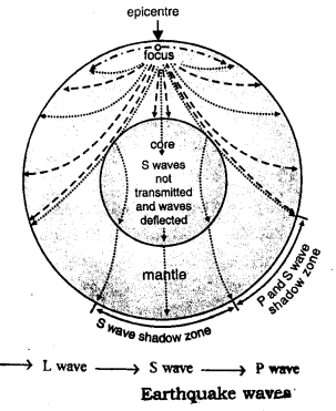
Seismic focus.is located in the interior of earth’s crust from where the earthquake waves originate and the epicenter is the nearest point vertically below the region of earthquake effect.
P Q. What is the Tsunami ? How is it produced ? What are its effects ?
Ans:
Here’s a concise and unique explanation of tsunamis:
A tsunami is a series of exceptionally long ocean waves, often incorrectly called “tidal waves,” that are generated by large-scale disturbances on or near the ocean floor. Unlike regular ocean waves that are primarily driven by wind, tsunamis are caused by the displacement of a massive volume of water.
How is it produced?
The primary mechanism for tsunami generation is sudden vertical displacement of the seafloor. This most commonly occurs due to:
- Underwater Earthquakes: The most frequent cause. When an earthquake occurs beneath the ocean and causes the seafloor to suddenly uplift or subside, it displaces the overlying water column. This displaced water then generates the tsunami waves. Specifically, thrust fault earthquakes (where one tectonic plate slides over another) are particularly effective at generating tsunamis.
- Submarine Landslides: Large-scale landslides on the ocean floor, often triggered by earthquakes or volcanic activity, can also displace vast amounts of water, leading to a tsunami.
- Volcanic Eruptions: Submarine volcanic eruptions or the collapse of volcanic islands can create rapid water displacement.
- Meteorite Impacts: Though extremely rare in modern times, a large meteorite impact in the ocean could generate a catastrophic tsunami.
Once generated, these waves travel across the open ocean at incredible speeds (sometimes over 800 km/h or 500 mph), often unnoticed in deep water due to their very long wavelength and low amplitude. As they approach shallower coastal areas, their speed decreases, but their height dramatically increases, leading to the destructive walls of water that crash upon the shore.
What are its effects?
The effects of a tsunami are devastating and far-reaching:
- Massive Flooding and Inundation: The primary effect is the rapid and extensive flooding of coastal areas, carrying debris and saltwater far inland.
- Infrastructure Destruction: Buildings, bridges, roads, and other structures are severely damaged or completely destroyed by the immense force of the water and the debris it carries.
- Loss of Life: The sudden arrival and powerful nature of tsunamis lead to significant loss of human life and injury.
- Environmental Degradation: Coastal ecosystems, including coral reefs, mangroves, and beaches, are severely damaged. Saltwater intrusion contaminates freshwater sources and agricultural land.
- Economic Disruption: Fishing industries, tourism, and other coastal economies are crippled. Recovery efforts are lengthy and costly.
- Long-term Displacement and Psychological Trauma: Survivors often face displacement, loss of livelihoods, and significant psychological distress.
- Disease Outbreaks: Contaminated water sources and poor sanitation in the aftermath can lead to outbreaks of waterborne diseases.
In short, a tsunami is a highly destructive natural disaster with profound immediate and long-term consequences for human populations and the environment. A tsunami is a series of powerful ocean waves, distinct from normal wind-driven waves, caused by the large-scale displacement of water.
How it is produced: Tsunamis are primarily generated by sudden, significant vertical movement of the seafloor, most commonly due to:
- Underwater Earthquakes: Especially powerful thrust fault earthquakes (where one tectonic plate slides over another) that cause the ocean floor to rapidly uplift or subside. This displaces the entire water column above, creating the initial waves.
- Submarine Landslides: Large collapses of material on the ocean floor, often triggered by earthquakes or volcanic activity, which displace vast amounts of water.
- Volcanic Eruptions: Explosive underwater eruptions or the collapse of volcanic islands can also generate tsunamis.
These initially small waves in the deep ocean travel at very high speeds (like a jet plane). As they near the coast and enter shallower waters, their speed decreases, but their height dramatically increases, forming destructive walls of water.
Effects: The impacts of a tsunami are catastrophic:
- Widespread Flooding and Destruction: Massive inundation of coastal areas, obliterating homes, infrastructure, and carrying debris far inland.
- Loss of Life: High mortality and injury rates due to drowning, impact from debris, and collapsing structures.
- Environmental Damage: Devastation of coastal ecosystems (coral reefs, mangroves), saltwater contamination of freshwater sources and agricultural land.
- Economic Ruin: Collapse of fishing, tourism, and other coastal industries, leading to prolonged economic recovery challenges.
- Displacement and Trauma: Mass displacement of populations and severe psychological distress among survivors.
- Secondary Hazards: Potential for fires, hazardous material spills, and increased risk of waterborne diseases in the aftermath.
Question 3.
Compare and contrast the constructive effects and the – destructive effects of an earthquake.
Ans:
Here’s the tool code to ensure I have all the necessary factual information to provide a comprehensive and accurate comparison: Earthquakes, powerful natural phenomena, exert a dual influence on our planet and its inhabitants, manifesting as both destructive and, surprisingly, constructive forces.
Destructive Effects (Negative Impacts):
The immediate and most visible impacts of earthquakes are overwhelmingly destructive:
- Loss of Life and Injury: This is the most tragic consequence, primarily due to collapsing buildings, falling debris, and secondary hazards.
- Infrastructure Damage: Buildings, bridges, roads, railways, and utilities (water, gas, electricity lines) are often severely damaged or destroyed, disrupting daily life and hindering rescue efforts.
- Fires: Ruptured gas lines and damaged electrical wires frequently lead to widespread fires, which can be difficult to control due to broken water mains.
- Landslides and Avalanches: Seismic shaking can destabilize slopes, triggering devastating landslides and avalanches, especially in mountainous regions.
- Tsunamis: Underwater earthquakes can generate massive ocean waves (tsunamis) that inundate coastal areas, causing immense destruction and loss of life far from the epicenter.
- Liquefaction: In areas with saturated loose soil, intense shaking can cause the soil to lose its strength and behave like a liquid, leading to structures sinking or toppling.
- Economic Disruption: The damage to infrastructure and businesses leads to significant economic losses, impacting livelihoods and national economies.
- Psychological Trauma: Survivors often experience long-term psychological distress, including anxiety, PTSD, and grief.
Constructive Effects (Positive Impacts):
While less apparent and often occurring over geological timescales, earthquakes can also have beneficial outcomes:
- Release of Stored Energy: Earthquakes are a natural mechanism for the Earth to release accumulated stress along fault lines. Without these releases, the build-up of pressure could lead to even more catastrophic events.
- Formation of New Landforms:
- Coastal Plains, Bays, and Inlets: Uplift or subsidence of land can create new coastal plains, or submerge existing areas to form bays and inlets, which can be advantageous for navigation and harbor development.
- Lakes and Valleys: Earthquakes can alter drainage patterns, creating new lakes or deepening existing valleys.
- Geysers and Hot Springs: Fissures created by earthquakes can allow groundwater to come into contact with heated rocks, leading to the formation of geysers and hot springs, which can have geothermal and even medicinal uses.
- Mineral Deposition: The movement of fluids through new fractures can facilitate the deposition of valuable minerals.
- Enhanced Water Availability (in some regions): Research suggests that in some dry regions, seismic activity can create fractures that allow rainwater to infiltrate deeper into the soil, benefiting tree growth and ecosystems.
- Improved Preparedness and Building Codes: The destructive lessons learned from past earthquakes often lead to the development of better building codes, improved disaster preparedness strategies, and advancements in seismic engineering, ultimately saving lives in future events.
- Scientific Insight: Earthquakes provide invaluable data for scientists to study the Earth’s interior, understand plate tectonics, and improve prediction and mitigation efforts.
Question 4.
Is it possible to predict an earthquake ? Give reasons to support your answer.
Ans:
Here’s why:
- Complexity of Earth’s Crust: The Earth’s crust is incredibly complex, with countless interconnected fault lines and varying rock types. The forces and stresses within it are constantly changing in ways that are difficult to monitor comprehensively.
- Lack of Reliable Precursors: While scientists observe some phenomena before earthquakes (like minor foreshocks, changes in ground deformation, or variations in groundwater levels), these are not consistent or unique to impending quakes. Many such changes occur without an earthquake following, and many earthquakes happen without these visible precursors.
- Sudden Release of Energy: Earthquakes are fundamentally the sudden release of built-up stress. This release can occur without clear, predictable warning signs, much like snapping a stick – it’s difficult to know the exact moment it will break, even if you’re bending it.
- Scale of the Problem: Even if we could monitor all the subtle changes, the sheer scale of the Earth’s active seismic zones makes comprehensive, real-time data collection and analysis for precise prediction an enormous, currently insurmountable challenge.
Question 5.
How are earthquakes distributed over the globe ?
Ans:
Global Earthquake Distribution: A Tectonic Tale
Our planet’s rigid outer layer, the lithosphere, is fragmented into colossal, slowly migrating segments. The vast majority of earthquakes occur precisely where these immense plates meet and interact.
The Pacific Ring of Fire: A Fiery Embrace
The Circum-Pacific Belt, famously known as the “Pacific Ring of Fire,” is the planet’s most active seismic stage. This vast horseshoe-shaped zone, encircling the Pacific Ocean, accounts for approximately 80% of the world’s most powerful earthquakes. Its defining feature is the dominance of convergent plate boundaries. Here, a denser oceanic plate dives beneath a lighter continental or another oceanic plate—a process called subduction.
The Alpide-Himalayan Belt: Colliding Continents
Another major seismic pathway is the Mid-World Mountain Belt, also referred to as the Alpide-Himalayan Belt. This extensive zone stretches from the Mediterranean across the formidable Himalayas and into Southeast Asia. Responsible for about 15-17% of global earthquakes, this belt is characterized by intense continent-on-continent collisions. A prime example is the ongoing northward push of the Indian plate against the Eurasian plate, which generates immense compressional forces and continuously uplifts towering mountain ranges.
The Mid-Atlantic Ridge: Spreading Apart
Here, tectonic plates are actively pulling apart, with new oceanic crust continuously forming in the rift. Earthquakes in this realm are typically shallower and less intense, directly reflecting the continuous expansion of the ocean floor.
Intraplate Earthquakes: The Quiet Tremors
Finally, intraplate earthquakes occur within the stable interiors of tectonic plates, far removed from their active boundaries. Though less frequent and generally weaker than their boundary-related counterparts, these tremors can still cause damage. Their occurrence is often linked to the reawakening of ancient, dormant fault lines or to stresses transmitted across vast distances from dynamic plate movements at the margins.
Question 6.
How is the intensity of earthquakes measured ? What instruments are used ?
Ans:
Earthquake Intensity: Assessing Local Impact
Earthquake intensity provides a localized measure of an earthquake’s impact, distinct from its singular magnitude (total energy released). It describes how severely ground shaking affects people, structures, and the natural environment at a given spot. This metric is inherently subjective and varies with distance from the epicenter, geological conditions (like the type of ground), and building quality, generally lessening further away from the quake’s origin.
The Modified Mercalli Intensity (MMI) Scale, a qualitative standard from I to XII, is used to gauge this local impact. Each level describes specific observable effects:
- I (Not Felt): Only detectable by sensitive instruments.
- VI (Strong): Felt by nearly everyone, causing minor damage like falling plaster.
- VIII (Severe): Significant damage to ordinary buildings, some partial collapses, and widespread panic.
- XII (Catastrophic): Complete devastation, with ground undulation, objects thrown, and near-total destruction of structures.
Intensity is determined by combining eyewitness reports, detailed assessments of structural damage, and analysis of instrumental data from seismographs. While the MMI scale is observational, seismograph readings of ground motion indirectly support and refine the qualitative descriptions of shaking and damage that define each Mercalli level. Therefore, intensity serves as a vital link between the scientific measurement of an earthquake and its tangible consequences for affected communities.
Practice Questions (Solved)
Question 1.
(a) What is an Earthquake ?
(b) How is it caused ?
(c) Describe the world’s distribution of earthquakes.
(d) What are the advantages and disadvantages of Earth quakes?
OR
What are the effects of Earthquakes ?
(e) Name the major earthquakes of India from 1991 to 1997.
Ans:
Understanding Earthquakes
An earthquake is a sudden, often violent shaking of the Earth’s surface. This geological event happens when a vast amount of stored energy within the lithosphere (Earth’s crust and upper mantle) is abruptly released. As this energy discharges, it generates seismic waves that spread outwards, causing the ground to vibrate, from subtle tremors to intense, damaging jolts.
The Genesis of Earthquakes
Stress builds up in the surrounding rock where these plates meet, pull apart, or slide past each other along geological fault lines. When this accumulated stress exceeds the rock’s ability to stretch, an instant rupture occurs, releasing the stored energy as seismic waves. The exact underground point where this rupture begins is called the hypocenter or focus, while the location directly above it on the Earth’s surface, which typically experiences the most severe shaking, is known as the epicenter.
Beyond plate tectonics, earthquakes can also be triggered by magma moving underground during volcanic activity, human activities like constructing large water reservoirs (leading to reservoir-induced seismicity), injecting wastewater deep underground, or the localized collapse of underground caverns.
Global Earthquake Distribution
Earthquakes don’t occur randomly; their global distribution follows distinct patterns, largely aligned with tectonic plate boundaries.
- The most seismically active area is the Circum-Pacific Belt, famously called the “Pacific Ring of Fire,” which encircles the Pacific Ocean and accounts for approximately 80% of the world’s seismic events.
- Another significant zone is the Mid-World Mountain Belt (also known as the Alpine-Himalayan Belt), stretching from southern Europe, across the Himalayas, and into Southeast Asia. This belt contributes roughly 15-17% of global earthquakes, primarily due to intense collisions between continental plates.
- Finally, the Mid-Atlantic Ridge, a divergent plate boundary where new oceanic crust forms, experiences less frequent and generally lower-magnitude seismic activity.
The Dual Nature of Earthquakes: Benefits and Detriments
Destructive Impacts
Earthquakes can cause a cascade of devastating consequences:
- Violent ground motion and rupture directly lead to catastrophic structural failures, including the collapse of buildings, bridges, and other vital infrastructure.
- In mountainous regions, they frequently trigger destructive landslides and avalanches.
- Submarine earthquakes often cause massive ocean waves called tsunamis, which can flood and obliterate coastal areas.
- Intense vibrations can also induce soil liquefaction, where saturated ground loses its solidity and behaves like a fluid.
- Furthermore, damaged gas lines and electrical wiring often ignite widespread fires, worsening the disaster.
- Ultimately, earthquakes inflict significant loss of human life, widespread injuries, and immense economic and property damage.
Constructive Impacts
Despite their destructive potential, earthquakes also offer some beneficial aspects:
- They are a crucial mechanism for the Earth to release enormous stresses accumulated from tectonic plate movements, potentially preventing even more catastrophic future ruptures.
- Over vast geological timescales, seismic activity plays a vital role in shaping the planet’s topography, contributing to the uplift of mountain ranges and the creation of depressions that can evolve into new lakes or bays.
- They can also bring valuable subterranean mineral deposits closer to the surface and cause shifts in groundwater levels, potentially giving rise to new springs or altering existing ones.
- Moreover, the meticulous study of seismic waves provides invaluable insights for seismologists, enabling them to decipher the intricate internal structure and composition of our own planet.
Notable Indian Earthquakes (1991-1997)
Between 1991 and 1997, India experienced two particularly impactful seismic events:
- Uttarkashi Earthquake (1991): This significant earthquake struck the Garhwal Himalayas in Uttarakhand in October 1991, causing considerable damage throughout the affected region.
- Latur Earthquake (1993): Despite its moderate magnitude, this quake resulted in extensive devastation and a high number of fatalities, largely due to the vulnerability of the region’s rural dwellings, which lacked adequate seismic resistance.
Question 2.
Name the important Earthquake-belts of the world.
OR
Indicate two major belts of Earthquakes.
Ans:
The Earth’s seismic activity is concentrated along two primary global belts, reflecting the dynamic interactions of its tectonic plates.
The Circum-Pacific Belt, often called the “Pacific Ring of Fire,” is the most prominent and active, responsible for about 80% of the world’s most powerful earthquakes. This horseshoe-shaped zone encircles the Pacific Ocean, tracing the boundaries where oceanic plates are largely subducting beneath continental ones. Its path includes the western edges of the Americas, the Aleutian Islands, Japan, the Philippines, Indonesia, and New Zealand, all characterized by intense seismic and volcanic activity.
The Mid-World Mountain Belt, also known as the Alpine-Himalayan Belt, accounts for approximately 15-17% of significant global earthquakes. Stretching from Europe’s Alps across the Caucasus and the vast Himalayan range into Southeast Asia, this belt is a direct consequence of massive continental collisions, notably the African, Arabian, and Indian plates converging with the Eurasian plate, generating immense compressional forces and substantial seismic events.
Question 3.
Name the instrument used to record Earthquakes.
Ans:
seismograph.
Question 4.
Name some Earthquakes which caused great damage.
Ans:
History bears witness to numerous earthquakes that have unleashed catastrophic damage and immense human suffering. Here are some notable examples:
- 1556 Shaanxi Earthquake (China): Considered the deadliest earthquake in recorded history, this magnitude 8 event caused an estimated 100,000 to over 800,000 fatalities, primarily due to the collapse of “yaodongs” (cave dwellings) built into loess cliffs. The devastation was widespread, affecting several provinces.
- 1976 Tangshan Earthquake (China): Official figures placed the death toll at around 242,000, though some estimates suggest it could have been significantly higher. The scale of destruction to infrastructure was immense.
- 2004 Indian Ocean Earthquake and Tsunami (Sumatra, Indonesia): A colossal magnitude 9.1-9.3 undersea earthquake generated a devastating tsunami that swept across the Indian Ocean, impacting 14 countries. It led to an estimated 227,898 deaths, making it one of the most tragic natural disasters in modern history.
- 2010 Haiti Earthquake (near Port-au-Prince): This magnitude 7.0 earthquake, while not exceptionally high in magnitude, proved exceptionally deadly due to Haiti’s vulnerable infrastructure and dense population. The death toll ranged widely in estimates, from 160,000 to over 300,000, with millions left homeless.
- 2011 Tōhoku Earthquake and Tsunami (Japan):Beyond the nearly 20,000 fatalities, it caused the Fukushima nuclear disaster and inflicted staggering economic damage.
- 2005 Kashmir Earthquake (Pakistan-administered Kashmir): A magnitude 7.6 earthquake in this mountainous region resulted in over 87,000 fatalities and widespread destruction of homes and infrastructure, particularly impacting remote villages.
- 2023 Turkey-Syria Earthquakes: A series of powerful earthquakes, with magnitudes up to 7.8 and 7.7, caused immense devastation across southeastern Turkey and northern Syria. The combined death toll exceeded 50,000, and millions were displaced, highlighting the critical role of building resilience.
Question 5.
Earthquakes occur in the Mid-Atlantic belt.
Ans:
Here’s a unique take on the Mid-Atlantic Belt’s seismic activity:
The Mid-Atlantic Belt stands out as a significant seismic zone, experiencing frequent tremors due to its function as a major divergent plate boundary. Here, the North American, Eurasian, South American, and African tectonic plates are in a ceaseless process of pulling away from each other along the Mid-Atlantic Ridge.
As these immense plates slowly diverge, molten material from the Earth’s mantle rises to fill the expanding gap, solidifying into fresh oceanic crust through a phenomenon known as seafloor spreading. This continuous creation of new crust, coupled with the tension and fracturing of the existing crust along this extensive underwater mountain range, directly triggers the many, typically shallow, earthquakes observed in this area. These seismic events are a clear indication of the powerful tectonic forces at work as the oceanic plates progressively separate.
Question 6.
How do earthquakes affect landscapes ?
Ans:
Earthquakes are powerful agents of landscape transformation, orchestrating both dramatic, immediate changes and gradual, long-term alterations to our planet’s surface.
Immediate Landscape Changes
The most direct impact often involves ground rupture along fault lines. Here, the Earth’s surface can visibly fracture, forming pronounced fissures, steplike scarps, or even trenches. These abrupt displacements can tear through infrastructure like roads and buildings, dramatically reshaping local topography.
Intense seismic shaking frequently triggers mass movements on slopes. This includes landslides, where vast quantities of rock and soil slide downslope, potentially burying valleys, damming rivers, and stripping away vegetation. In steep, rocky areas, rockfalls are common, sending debris cascading downwards. Such events profoundly alter hillsides and mountain contours.
This can cause structures to tilt, sink, or even float, while the surface cracks and bulges, fundamentally changing the stability and appearance of flat, low-lying areas.
Vertical crustal movements, encompassing both subsidence (sinking) and uplift (rising), can drastically modify coastal and low-lying regions. Uplifted coastlines might expose new land, while subsidence can submerge previously dry areas, leading to the formation of new bays or the expansion of wetlands.
Upon reaching shorelines, these destructive waves inundate vast land stretches, scouring beaches, reshaping coastlines, depositing significant amounts of sediment and debris, and drastically altering coastal ecosystems.
Earthquakes can also directly modify water bodies. Fault movements have the power to reroute rivers, creating entirely new channels or abandoning old ones. Lakes can form in new depressions, or conversely, be drained by newly formed fissures. Groundwater levels can fluctuate dramatically, with some springs drying up and others emerging anew.
Long-Term Geological Sculpting
Over vast geological timescales, the repeated seismic activity along fault lines becomes a primary driver in mountain building and the development of major geological features. The cumulative effect of countless quakes contributes significantly to the gradual uplift of majestic mountain ranges and the formation of extensive valleys and basins, perpetually sculpting the Earth’s surface.
Question 7.
What was the cause of the Koyna earthquake in India ?
Ans:
The Koyna earthquake of 1967 stands as a key instance of reservoir-induced seismicity (RIS), a phenomenon stemming from the interaction between large water bodies and geological structures.
Its primary cause is linked to the Koyna and Warna reservoirs’ impoundment and fluctuating water levels. The colossal volume of water exerts immense pressure on the underlying rock. More crucially, this water permeates existing geological faults and fractures, significantly elevating pore fluid pressure within these cracks. This elevated pressure effectively lubricates the fault lines, diminishing the friction that usually resists movement.
The Koyna area, despite being on a stable continental plate, possesses a network of pre-existing faults. These faults were already at a “critically stressed” state due to regional tectonic forces (derived from the ongoing Indian-Eurasian plate collision). The additional stress from the reservoir’s weight combined with the reduced friction from the infiltrating water pushed these faults to rupture.
Question 8.
Describe the main type of Earthquake Waves.
Ans:
Earthquakes release energy through three primary seismic waves, each with distinct travel patterns and motion characteristics:
P-waves (Primary Waves) are the fastest, acting as the initial messenger of seismic activity. These are compressional waves, much like sound, that propel particles back and forth along their travel path. Their remarkable ability to move through solids, liquids, and gases allows them to be detected universally across Earth’s interior, often felt as a sharp, sudden jolt.
S-waves (Secondary Waves) follow P-waves, traveling at a slower pace. These are shear waves, causing particles to oscillate perpendicularly to the wave’s direction, resulting in a noticeable side-to-side or up-and-down shaking. A critical distinction is their inability to traverse liquids or gases, limiting their passage to solid materials. Their arrival is typically experienced as a more pronounced, swaying or undulating motion.
Bringing up the rear in terms of speed, but frequently responsible for the most significant damage, are Surface Waves (L-waves/Long Waves). Unlike P and S waves that penetrate the Earth’s interior, these waves propagate solely along the planet’s outermost layer. Surface waves primarily manifest in two forms:
- Love waves exhibit a distinct horizontal, side-to-side ground motion, akin to a serpent’s movement.
- Rayleigh waves create a complex, rolling motion, similar to ocean swells, simultaneously lifting and lowering the ground while moving it horizontally.
Question 9.
Name the causes of earthquakes.
Ans:
Here are the primary causes of earthquakes:
Earthquakes fundamentally stem from the release of accumulated stress within the Earth’s lithosphere. The most significant driver is plate tectonics, where the constant, slow motion of massive crustal plates leads to immense pressure buildup at their boundaries. When this stress exceeds the strength of the rocks, they rupture along fault lines, causing sudden slippage and seismic vibrations.
Less commonly, earthquakes can be triggered by volcanic activity, as the movement of magma beneath the surface creates pressure and tremors. Additionally, certain human activities can induce seismicity, such as large-scale dam construction and reservoir impoundment, underground nuclear tests, or extensive fluid injection/withdrawal during industrial processes.
Question 10.
Why are earthquakes related to volcanoes ?
Ans:
Earthquakes and volcanoes are intimately linked, largely due to their shared origin in the dynamic processes occurring within the Earth’s interior, primarily plate tectonics.
Here’s how they are related:
- Plate Boundaries: Both earthquakes and volcanoes are most common along the edges of tectonic plates. These are zones of intense geological activity where plates are colliding, pulling apart, or sliding past each other.
- Convergent Boundaries: Where plates collide, one often slides beneath the other (subduction). This process generates immense pressure and friction, leading to powerful earthquakes. The subducting plate also melts as it descends, forming magma that rises to the surface, creating volcanoes (e.g., the Pacific Ring of Fire).
- Divergent Boundaries: Where plates pull apart, magma rises from the mantle to fill the gap, forming a new crust. This process is often accompanied by frequent, but generally smaller, earthquakes and volcanic eruptions (e.g., Mid-Atlantic Ridge).
- Transform Boundaries: Where plates slide horizontally past each other, friction causes massive stress to build up, which is then released as major earthquakes. While less directly associated with large-scale volcanism, some smaller, localized volcanic features can occur.
- Magma Movement: The movement of molten rock (magma) beneath the Earth’s surface directly causes a specific type of earthquake known as volcano-tectonic earthquakes.
- These “magma-induced” earthquakes are often shallower and smaller in magnitude than tectonic earthquakes but are crucial indicators for monitoring volcanic activity.
- Volcanic tremors are continuous, rhythmic ground shaking caused by the sustained movement of magma and gases within a volcano’s plumbing system, often signaling an impending eruption.
- Triggering Events:
- Earthquakes triggering eruptions: While not every large earthquake triggers an eruption, a significant tectonic earthquake in a volcanically active region can sometimes disturb a magma chamber that is already pressurized and “poised to erupt.” The shaking can reduce pressure, allow gases to escape from the magma (like shaking a soda bottle), and potentially trigger an eruption.
- Volcanoes triggering earthquakes: The movement of magma, or even the eruption itself, can induce stress changes in the surrounding crust, leading to earthquakes. For instance, the collapse of a volcano’s caldera after a major eruption can also generate seismic activity.
