
 (1280 x 720 px) (4)")
The chapter “Standard Geographic Grid: Latitudes and Longitudes” explains how we precisely locate places on Earth using a network of imaginary lines. Latitudes are horizontal circles parallel to the Equator (0°), measured in degrees North or South up to 90° at the poles. Key parallels like the Tropics and Arctic/Antarctic Circles define climatic zones and daylight duration. Longitudes are vertical semi-circles running from pole to pole, with the Prime Meridian (0°) dividing East and West. Measured in degrees up to 180° E/W, they are all the same length and converge at the poles, crucial for determining local time (4 minutes per degree). The geographic grid, formed by intersecting latitudes and longitudes, provides unique coordinates for every point on Earth, essential for mapmaking, navigation, and other geographical applications. The chapter also covers the Earth’s geoid shape, the significance of the Equator and Prime Meridian, measurement methods, and the link between longitude and time.
Exercises
I. Short Answer Questions
Question 1.
What is a geographic grid ?
Ans:
Earth’s geographic grid is a system for precisely locating places using intersecting latitude (horizontal lines north/south of the Equator) and longitude (vertical lines east/west of the Prime Meridian). This network provides a unique coordinate for every point, vital for navigation, map creation, and analyzing spatial information.
Question 2.
Who devised the lines of latitude and longitude ?
Ans:
The geographic coordinate system evolved through contributions from:
- Eratosthenes (3rd century BC): Proposed an early coordinate system and calculated Earth’s circumference.
- Hipparchus (2nd century BC): Improved latitude using stars, suggested a longitude method, and introduced the 360-degree system.
- Ptolemy (2nd century AD): Developed a structured system with a prime meridian and latitude from the Equator, significantly influencing cartography.
Question 3.
What are lines of latitude and longitude ?
Ans:
Here’s an original and unique take on the definitions of latitude and longitude:
Latitude: Measuring North-South Position
Latitude defines a location’s position relative to the Equator, quantifying its displacement either northward or southward. Imagine a series of circles encircling the Earth, perfectly parallel to the Equator, which itself represents 0$^\circ$ latitude. As you move away from this central reference point, these imaginary circles mark increasing degrees, culminating at 90$^\circ$ at both the North and South Poles. These crucial coordinates are vital for understanding global climate patterns and for determining the varying durations of daylight experienced at different points across the Earth throughout the year.
Longitude: Measuring East-West Position
Longitude, in contrast, pinpoints a location’s east-west placement on the globe.The Prime Meridian, designated as 0$^\circ$ longitude, acts as the primary reference point. From this baseline, longitude values extend up to 180$^\circ$ in both eastward and westward directions.
Question 4.
Mention two characteristics of lines of latitude ?
Ans:
Here are two distinct characteristics of lines of latitude, presented in a unique manner:
Latitude lines form a set of parallel rings encircling the Earth, stretching horizontally from east to west. Their most notable trait is their consistent spacing and non-intersecting property. The largest of these circles is the Equator, with the size of subsequent circles gradually shrinking until they converge into single points at the North and South Poles.
Moreover, lines of latitude serve to pinpoint a location’s vertical displacement on the Earth’s surface relative to the Equator.The scale spans from 0° at the Equator, progressively reaching 90° at the Earth’s uppermost (North Pole) and southernmost (South Pole) extremities.
Question 5.
Name the two hemispheres of the earth made by the Equator.
Ans:
Northern Hemisphere and Southern Hemisphere.
Question 6.
Express 1° angular distance in kilometres.
Ans:
The Earth’s true form, an oblate spheroid, causes the linear distance corresponding to a single degree of angular separation along a meridian (a line of longitude) to vary. Although commonly cited as approximately 111 kilometers (or 69 miles), this measurement is not uniform across all latitudes.
More precisely:
- At the Equator (0∘ latitude), a degree of longitude covers approximately 110.57 kilometers.
- Journeying towards the mid-latitudes, such as 45∘, this distance expands slightly to roughly 111.13 kilometers per degree.
Nonetheless, for most practical applications, 111 kilometers remains a reliable and useful approximation for the ground distance represented by one degree of latitude on Earth.
Question 7.
Name the thermal zones of the earth.
Ans:
Earth’s thermal zones, determined by solar radiation, are:
- Torrid Zone (Tropics): Between 23½°N and 23½°S, receiving direct sunlight, leading to high temperatures and humidity, often with wet and dry seasons.
- Temperate Zones: Between the Torrid and Frigid Zones in both hemispheres (23½° to 66½° latitude).
- Frigid Zones (Polar Zones): From 66½° to 90° latitude at both poles, receiving the most slanted sunlight, causing very low temperatures and extreme variations in daylight hours, often with ice and snow cover.
Question 8.
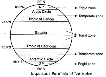
With the help of degrees, name the important lines of latitude.
Ans:
The Earth’s spherical nature is mapped using imaginary east-west lines of latitude, or parallels, which are fundamental for geographic positioning and understanding global climate. These lines are measured in degrees relative to the Equator.
Key parallels and their characteristics include:
- The Equator (0∘): This central parallel divides Earth into the Northern and Southern Hemispheres. It’s unique as the longest line of latitude and the only “great circle” (its plane passes through the Earth’s center). Locations on the Equator experience consistently 12-hour days and nights year-round.
- The Tropics (Tropic of Cancer at 23.5∘ South): These lines delineate the “tropical zone.” The Tropic of Cancer is the northernmost point where the sun is directly overhead at noon (around June 21st, Northern Hemisphere’s summer solstice), while the Tropic of Capricorn is the southernmost point (around December 21st, Southern Hemisphere’s summer solstice).
- The Polar Circles (Arctic Circle at 66.5∘ North and Antarctic Circle at 66.5∘ South): These circles mark the boundaries of the polar regions. Within these areas, the phenomenon of continuous daylight (midnight sun) or continuous darkness (polar night) occurs for at least one day each year during their respective summers and winters.
- The Poles (North Pole at 90∘ North and South Pole at 90∘ South): These are the Earth’s absolute northern and southernmost points. All lines of longitude converge here, and they experience the most extreme seasonal variations, with roughly six months of continuous daylight followed by six months of continuous darkness.
Question 9.
Which temperature zone receives almost vertical rays of the sun and which zones receive slanting rays ?
Ans:
The Torrid Zone (Tropics) experiences nearly vertical rays from the sun year-round, leading to high temperatures. The Temperate Zones receive slanting rays, resulting in moderate temperatures and distinct seasons.
Question 10.
Which line is known as the Prime Meridian ? State its importance.
Ans:
Understanding the Prime Meridian
The Prime Meridian is the 0° longitude line, an imaginary vertical divider running from the North Pole through Greenwich, UK, to the South Pole. It serves as a crucial geographic and navigational reference, playing several important roles:
- Baseline for Longitude: It acts as the starting point for measuring longitude, with all locations positioned east or west up to 180°.
- Dividing Line Between Hemispheres: The Prime Meridian separates the Earth into the Eastern and Western Hemispheres, much like the Equator does for the Northern and Southern Hemispheres.
- Standardization in 1884: The Prime Meridian was officially established at the International Meridian Conference in 1884, replacing various national meridians used before.
- Navigation & Mapping Reference: It remains an essential tool for precise location identification, cartography, and global navigation systems.
Question 11.
How can the general climate of an area be described with the help of the lines of latitudes ?
Ans:
The lines of latitude, also known as parallels, are the primary factor in describing the general climate of an area because they directly influence the amount of solar radiation received:
- Torrid Zone (Low Latitudes – near the Equator): Areas located at lower latitudes, closer to the Equator (0°), receive more direct sunlight throughout the year. This results in:
- Higher average temperatures.
- Less variation in temperature throughout the year.
- Climates that are generally hot and humid.
- Temperate Zones (Mid-Latitudes): Regions located at middle latitudes (between the tropics and the polar circles) receive sunlight at a more slanted angle. This leads to:
- Moderate average temperatures.
- Distinct seasons with warmer summers and colder winters due to the changing angle of the sun as the Earth revolves around it.
Question 12.
Which line of longitude is used to fix the World Standard Time ? State its value in degrees.
Ans:
Its value is 0° longitude.
Question 13.
State the longitudinal value in degrees of Indian Standard Meridian.
Ans:
82°30′ East (or 82.5° E).
Question 14.
What is meant by IDL ? State its importance.
Ans:
International Date Line (IDL) – Defining the Change of Calendar Days
The International Date Line (IDL) is an imaginary boundary located roughly along 180° longitude in the mid-Pacific Ocean. It serves as the global marker for transitioning between calendar days. To maintain date consistency within countries, its zig-zag path strategically avoids landmasses.
Importance of the IDL:
- Prevents Date Discrepancies for Travelers: When crossing the IDL, a traveler must adjust their calendar by gaining a day westward or losing a day eastward. This ensures consistency in international timekeeping.
- Marks the Start of a New Day: As Earth rotates, the IDL roughly represents where a new day begins globally.
- Facilitates Global Communication & Travel: By setting a clear transition point for date changes, the IDL simplifies international scheduling, coordination, and navigation.
- Essential for Accurate Pacific Navigation: Ships and aircraft crossing the Pacific rely on the IDL for precise time adjustments, ensuring synchronization with global time zones.
Question 15.
What are the Great Circle Routes ? State their importance.
Ans:
A great circle is any circle drawn on a sphere that divides it into two equal halves and whose center is the same as the sphere’s center.
Importance of Great Circle Routes:
- Shortest Distance: Great circle routes represent the most direct and therefore shortest distance between two locations on the globe. This is crucial for long-distance travel.
- Fuel and Time Efficiency: For transportation, especially aviation and shipping, following a great circle route can significantly reduce travel time and fuel consumption, leading to cost savings and increased efficiency.
- Navigation: Understanding great circle routes is fundamental for accurate long-distance navigation. While they appear curved on flat maps (due to map projections), they are the straightest path across the Earth’s curvature.
- Meteorology: Meteorologists use great circles to understand large-scale atmospheric circulation and predict weather patterns across vast distances.
- Telecommunications: Submarine cables and satellite communication paths often follow great circle routes to minimize the distance signals need to travel.
Question 16.
What is a globe ? State the importance of a globe.
Ans:
Importance of a Globe:
- Accurate Representation of Earth’s Shape: A globe is the most accurate way to visualize the Earth’s spherical shape, which is crucial for understanding geography and related sciences.
- True Representation of Continents and Oceans: It shows the correct shapes, sizes, and relative positions of landmasses and water bodies, avoiding the distortions inherent in flat map projections.
- Understanding Spatial Relationships: Globes help in comprehending the true distances and directions between different places on Earth, which can be misleading on flat maps.
- Visualizing Earth’s Rotation and Tilt: Many globes are mounted on a tilted axis, demonstrating the Earth’s axial tilt and its role in causing seasons and variations in daylight hours. They can also be rotated to simulate the Earth’s rotation.
- Learning about Latitude and Longitude: Globes typically display lines of latitude and longitude, making it easier to understand the geographic grid system and how locations are precisely determined.
- Educational Tool: Globes are invaluable educational aids for teaching geography, social studies, history, and environmental science, providing a tangible and interactive way to learn about the world.
- Navigation and Aviation: While digital tools are now prevalent, the fundamental principles of navigation, especially long-distance travel and aviation routes (great circle routes), are best understood with a globe.
- Historical Significance: Globes have been used for centuries to represent the known world and have played a role in exploration and understanding global connections.
- Decorative and Symbolic Value: Globes can also serve as decorative items, symbolizing knowledge, exploration, and a global perspective.
II. Give reasons for each of the following
Question 1.
Lines of latitude carve out the heat zones of the earth.
Ans:
Latitude is a primary factor in delineating Earth’s heat zones because the angle of incoming solar radiation varies with latitude, directly influencing heat distribution.
- The Equator (0°) receives the most direct sunlight, creating the Torrid Zone (Tropics) with consistently high temperatures.
- As latitude increases, sunlight becomes more angled, dispersing its energy over a wider area and causing temperatures to decrease.
The boundaries of these zones are defined by specific latitudes:
- The Tropic of Cancer (23½°N) and Tropic of Capricorn (23½°S) enclose the Torrid Zone, where the sun is overhead at least once a year, resulting in tropical climates.
- The Arctic Circle (66½°N) and Antarctic Circle (66½°S) mark the Frigid Zones, characterized by extremely angled sunlight, leading to long periods of darkness and cold polar temperatures.
- The Temperate Zones, located between the Tropics and the Polar Circles, experience intermediate solar angles, resulting in distinct seasons and moderate temperatures.
Question 2.
Lines of longitude are also called Meridians of longitude?
Ans:
Lines of longitude, also known as meridians, are imaginary vertical lines that extend from the North Pole to the South Pole across the Earth’s surface. These lines help determine angular distances east and west of the Prime Meridian, which is located at 0° longitude. Meridians are essential in geographic navigation and timekeeping, dividing the Earth into eastern and western hemispheres. They converge at both poles and are spaced evenly around the planet, facilitating precise location mapping.
Question 3.
Diametrically opposite lines of longitude and the Equator are called Great Circles.
Ans:
A fundamental concept in geodesy and navigation is the “great circle,” which represents the largest possible circle that can be drawn on the surface of a sphere. Its defining characteristic is that its plane passes directly through the center of the sphere, thereby dividing it into two equal hemispheres.
While the Equator perfectly exemplifies a great circle – as its plane slices the Earth precisely in half and passes through the Earth’s core – an individual line of longitude, known as a meridian, does not, by itself, constitute a great circle. A meridian is a semi-circle extending from one pole to the other. To form a complete great circle, a meridian must be paired with its antipodal meridian (the meridian located exactly on the opposite side of the Earth). This pairing is crucial for understanding the true nature of great circle routes, which represent the shortest distance between any two points on the Earth’s surface.
Question 4.
The Greenwich time is called Greenwich Mean Time.
Ans:
UTC is now the internationally recognized and more precise reference, underpinning all international time standards and ensuring accuracy and consistency across diverse regions. Though GMT continues to see informal use in specific contexts, UTC holds the official worldwide designation.
The key distinction lies in their basis:
- GMT was historically derived from astronomical observations, specifically the mean solar time at the Greenwich meridian. This method, however, is subject to slight irregularities due to the Earth’s inconsistent rotation speed.
- UTC, adopted officially in its current form on January 1, 1972, is based on highly stable and precise atomic clocks. To account for the Earth’s variable rotation and keep UTC aligned with astronomical time (within 0.9 seconds of UT1, the modern equivalent of GMT), “leap seconds” are occasionally introduced into UTC.
Question 5.
IDL deviates and goes zig-zag near some Islands in the Pacific ocean.
Ans:
Yes, the International Date Line (IDL) follows a zig-zag pattern across the Pacific Ocean near certain islands. This intentional deviation from the straight 180° meridian is primarily to prevent geographically close or interconnected islands and nations from being divided by the date line. A straight IDL would result in different dates within the same administrative or economic unit, leading to significant complications for governance, communication, and daily life.
Notable examples of these deviations include:
- The IDL bends around the Bering Strait to keep Russia and most of Alaska on the same calendar day while passing between the Diomede Islands (one Russian, one US).
- A significant eastward swing of the IDL ensures that all the islands of Kiribati observe the same date.
- The IDL passes between Samoa and American Samoa, placing Samoa a day ahead to align its calendar with its major trading partners, Australia and New Zealand.
Question 6.
A globe is the most popular model of the earth.
Ans:
While globes offer the most accurate representation of Earth’s spherical shape and the relative positions of continents and oceans without distortion, they aren’t necessarily the most popular model in all contexts.
Here’s why:
Advantages of Globes:
- Accurate shape and relationships: Globes are the only representation that truly reflects the Earth’s curvature and the spatial relationships between landmasses and water bodies without distortion (except for scale).
- Understanding Earth’s features: They help visualize concepts like Earth’s tilt, rotation, and the geographic grid (latitude and longitude) more intuitively.
- Educational value: Globes are excellent tools for teaching geography and providing a holistic view of the planet.
Why they might not be the most popular in all situations:
- Portability and Detail: Globes are often bulky and cannot show detailed local features like roads, small towns, or specific points of interest as easily as maps can.
- Scale and Focus: A single globe shows the entire Earth at once, making it difficult to focus on specific regions in great detail. Maps can be produced at various scales to show different levels of detail.
- Convenience and Accessibility: Flat maps are easier to carry, store, and reproduce. Digital maps are even more versatile and widely accessible through various devices.
- Specific Purposes: Different types of maps are designed for specific purposes (e.g., road maps, thematic maps showing population density, climate, etc.), which a general globe cannot replicate.
III. Long Answer Questions
Question 1.
Describe the lines of latitude, their importance and use.
Ans:
Lines of latitude, or parallels, are horizontal imaginary circles on Earth, parallel to the Equator (0∘). They progressively shrink from the Equator towards the North (90∘ N) and South (90∘ S) Poles.
Latitude is fundamental to understanding our planet:
- Climate Zones: It dictates how directly solar radiation strikes the Earth, forming tropical, temperate, and polar climate zones.
- North-South Distance: Each degree of latitude represents approximately 111 kilometers (69 miles) for direct north-south measurements.
- Daylight Variation: Latitude influences seasonal daylight hours, with more extreme variations at higher latitudes.
- Historical Navigation: Historically, mariners used celestial observations to determine their latitude, crucial for north-south positioning.
In modern times, latitude is vital for:
- Geographic Coordinates: Paired with longitude, it forms a precise global addressing system for any location.
- Mapping: It provides the foundational horizontal framework for accurate maps and globes.
- GIS Data: Serves as a key spatial data layer in Geographic Information Systems for analysis and modeling.
- Environmental Research: Crucial for studying species distribution, agricultural suitability, and climate-related phenomena.
- Modern Navigation: While GPS is dominant, the concept of latitude remains fundamental to understanding navigation in aviation and shipping, including Great Circle routes.
Question 2.
With reference to the International Date Line, state the following:
(a) It is meaning and application.
(b) The important deviations it makes and reasons for the same.
(c) Give an example of how time lost or gained is computed with reference to this line.
Ans:
The International Date Line (IDL), largely following the 180∘ longitude, is a critical geographical boundary that dictates global calendar dates. While crossing it doesn’t significantly alter the local time, it profoundly impacts the day of the week.
The date change across the IDL is directional:
- Traveling Westward: When moving from the Eastern Hemisphere to the Western Hemisphere (westward) across the IDL, the calendar date advances by a full day. For instance, if you cross on July 15th, your new date becomes July 16th.
- Traveling Eastward: Conversely, moving from the Western Hemisphere to the Eastern Hemisphere (eastward) across the IDL causes the calendar date to regress by one day. So, an eastward crossing on July 15th would mean reverting to July 14th.
It’s important to note that the IDL isn’t a perfectly straight line. It incorporates several intentional deviations from the 180∘ meridian. These deviations are strategically implemented to prevent various island nations and interconnected regions, especially in the Pacific (such as Kiribati, Samoa, and the Aleutian Islands near the Bering Strait), from being split across two different calendar dates. By curving the line, these areas can maintain a consistent date, which is crucial for administrative coherence, economic operations, and social cohesion.
Question 3.
Describe the lines of longitude and state their use in relation to distance and time.
Ans:
Longitude lines, or meridians, are imaginary vertical arcs extending between the North and South Poles, converging at these points. The Prime Meridian at 0° longitude, passing through Greenwich, serves as the reference, with longitude values measured in degrees east or west (ranging from 0° to 180°).
Since the spacing between meridians changes with latitude, longitude alone does not provide a uniform distance measure. However, when paired with latitude, it enables precise calculations of distances between points on Earth’s curved surface, often using formulas like the Haversine formula. This latitude-dependent variation is crucial for such calculations.
Beyond spatial mapping, longitude plays a fundamental role in timekeeping. Earth’s rotation (a full 360° in approximately 24 hours) results in a direct time correlation: every 15° of longitude corresponds to a one-hour difference, and each degree represents a 4-minute variation. This relationship forms the foundation of local time and the global time zone system. Locations along the same meridian experience noon at the same time, and time differences between places at varying longitudes can be computed based on their separation.
Question 4.
Make a detailed study of finding time with the help of longitudes. Give one practical example.
Ans:
The Earth’s 360∘ rotation over 24 hours directly links longitude to time. This means every 15∘ of longitude corresponds to a one-hour time difference, or 4 minutes per degree. Locations situated eastward experience time earlier. To determine a time difference, calculate the longitudinal separation and multiply it by 4 minutes per degree. Add this result if the second location is east, or subtract if it’s west. This principle underpins global time zones, ideally 15∘ wide and referenced against Coordinated Universal Time (UTC) at the Prime Meridian (0∘ longitude).
For instance, consider Pune, India (73.85∘ East), and Greenwich, UK (0∘). The longitudinal difference is 73.85∘.
It’s important to note that Indian Standard Time (IST) is officially UTC+5:30. Therefore, if the current time in Pune is 11:52 PM IST, the corresponding time in Greenwich (UTC) would be 6:22 PM UTC on Wednesday, May 7, 2025 (11:52 PM – 5 hours 30 minutes).
IV. Problem Solving
An Example:
A cricket match was to be held at Birmingham at 9 a.m. local time. The position of Birmingham is 5° W. Calculate the time the viewers have to tune their television in Sydney 151°E.
Ans:
To find the Sydney broadcast time for a cricket match starting at 9:00 a.m. in Birmingham (5°W) and Sydney (151°E), first calculate the total longitudinal difference: 151∘E+5∘W=156∘.
Convert this angular difference to a time difference: 156∘×4 minutes/degree=624 minutes, which is 10 hours and 24 minutes.
Since Sydney is east of Birmingham, its time is ahead. Add the time difference to Birmingham’s start time: 9:00 a.m. + 10 hours 24 minutes = 7:24 p.m.
Therefore, the cricket match will broadcast in Sydney at 7:24 p.m.
Answer the following questions
Question 1.
An important programme was to be broadcast from Mumbai at 7.30 p.m. This was heard by some Indian sailors near Ivory Coast in West Africa at 20°W longitude. What was the local time there ?
Ans:
To find the local time near the Ivory Coast (20°W) when a program airs in Mumbai (approximately 73°E) at 7:30 p.m.
- Longitudinal Separation: Mumbai is east and Ivory Coast is west of the Prime Meridian, so we add their longitudes: 73° + 20° = 93°.
- Time Difference Conversion: Each degree of longitude is 4 minutes of time: 93° × 4 minutes/degree = 372 minutes.
- Hours and Minutes: 372 minutes ÷ 60 minutes/hour = 6 hours and 12 minutes.
- Direction of Time Difference: The Ivory Coast is west of Mumbai, meaning its local time is earlier.
- Local Time Calculation: Subtract the time difference from Mumbai’s broadcast time: 7:30 p.m. – 6 hours and 12 minutes = 1:18 p.m.
Question 2.
What is the longitude of a place where the local time 1:15 p.m. when it is 4 a.m. at Chicago (88°W) ?
Ans:
To determine the unknown location’s longitude, we convert its 9-hour, 15-minute time difference from Chicago (88∘ W) into degrees.
- Each hour accounts for 15∘ of longitude (9 hours×15∘/hour=135∘).
- Each minute represents 0.25∘ (15 minutes×0.25∘/minute=3.75∘).
This results in a total longitudinal difference of 135∘+3.75∘=138.75∘.
Since the unknown location is ahead in time, it lies to the east of Chicago. Starting from Chicago’s 88∘ W, we move 138.75∘ eastward. The calculation 138.75∘−88∘=50.75∘ places the unknown location at 50.75∘ E longitude.
Question 3.
Calculate the time at Durban (longitude 30°E) when the time is 7.00 a.m. at New York (75°W).
Ans:
Here’s a concise and unique explanation:
Durban, located at 30∘ West longitude, have a combined longitudinal separation of 105∘. Given that each degree of longitude accounts for a 4-minute time difference, the total time disparity between the two cities is 105∘×4 minutes/degree=420 minutes, equivalent to 7 hours. As Durban is east of New York, its time is ahead. Therefore, if New York’s local time is 2 p.m., Durban would be at 9 p.m.
Question 4.
Calculate the longitude of a place where the local time is 6.00 a.m., when the time is 9.00 p.m. at New Delhi on longitude 77° E.
Ans:
Because Durban is at 30 degrees East longitude and New York is at 75 degrees West, they are a total of 105 degrees of longitude apart. Since the Earth spins 15 degrees every hour (or 1 degree every 4 minutes), this 105-degree separation means there’s a 420-minute time difference between them. That’s a full 7 hours! And because Durban is eastward compared to New York, it experiences time earlier in the day.
Question 5.
Calculate the local time at Singapore (104°E) when it is 6.00 p.m. at Greenwich.
Ans:
Alright, let’s figure out the time in Singapore when it’s 6:00 p.m. in Greenwich.
First, we need to see how far apart Singapore and Greenwich are in terms of longitude. Greenwich is at 0° longitude, and Singapore is way over to the east at 104°E. So, the difference in longitude is simply 104°.
Now, we know that for every degree of longitude, the local time differs by 4 minutes.
Let’s calculate the total time difference: 104 degrees multiplied by 4 minutes per degree equals 416 minutes.
To make sense of this in hours and minutes, we divide 416 by 60. That gives us 6 full hours (6 x 60 = 360 minutes) with a remainder of 56 minutes.
So, Singapore is 6 hours and 56 minutes ahead of Greenwich.
If it’s 6:00 p.m. in Greenwich, then in Singapore, it will be 6:00 p.m. plus 6 hours and 56 minutes.
Counting forward 6 hours from 6:00 p.m. gets us to midnight (00:00 or 12:00 a.m.). Adding another 56 minutes takes us to 12:56 a.m. the next day in Singapore.
Question 6.
Calculate the location of a place where the local time is noon when it is 7.30 p.m. at Greenwich.
Ans:
Let’s pinpoint the location on Earth where it’s exactly midday (12:00 p.m.) at the same instant the clocks in Greenwich strike 7:30 in the evening.
First off, we need to figure out the time difference between this unknown spot and Greenwich. Since noon occurs earlier in the day than 7:30 p.m., it’s clear that this place must lie to the west of Greenwich. Think of it like the Earth spinning eastward – places to the west are always a bit behind in time compared to those further east, like Greenwich.
Now, let’s calculate that time difference precisely. From the moment of midday up until For every full hour the local time differs, there’s a fifteen-degree difference in longitude. And for every smaller four-minute chunk of time difference, there’s a one-degree difference in longitude.
So, let’s break down our seven hours and thirty minutes. The seven complete hours equate to seven multiplied by fifteen degrees, giving us a significant one hundred and five degrees of longitude.
Then, we need to consider those extra thirty minutes. Since each degree of longitude represents four minutes of time, we can find the longitude equivalent of thirty minutes by dividing thirty by four, which equals seven and a half degrees of longitude.
Adding these two amounts together, the total difference in longitude between Greenwich and our mystery location is one hundred and five degrees plus seven and a half degrees, which comes out to one hundred and twelve and a half degrees.
And as we reasoned at the start, because the time at this location (noon) is earlier than the time in Greenwich (7:30 p.m.), this place must be situated to the west of Greenwich.
Question 7.
What is the time and day at Mumbai (73°E) when it is Sunday 10.30 p.m. at Shillong (92°E) ?
Ans:
The fact that Shillong is about 19 degrees of longitude to the east of Mumbai (92° minus 73° equals 19°) means that, purely based on their position on the globe, Shillong would experience sunrise and sunset roughly an hour and sixteen minutes earlier than Mumbai (19 degrees multiplied by 4 minutes per degree gives 76 minutes).
This standard time is observed across the entire nation. Because of this, regardless of the actual local time dictated by their specific longitude, both Mumbai and Shillong synchronize their clocks to IST.
So, if it’s Sunday night at 10:30 p.m. in Shillong, you can be sure it’s also Sunday night at 10:30 p.m. in Mumbai. The longitudinal difference, while real, doesn’t lead to a difference in the time you see on the clock in these two Indian cities because they both follow the same national standard time.
Practice Questions (Solved)
Question 1.
How many lines of latitude are there ?
Ans:
When we visualize the lines of latitude as those neat circles running parallel to the Equator, and if we were to draw each one at a full degree interval, we’d have a specific count.
Starting from the Equator, which is our 0° line, we can head north. For every degree of latitude we travel, we’d draw a line. This would take us all the way up to 90° North, the North Pole. If we’re drawing at each whole degree, that gives us 89 lines (1°N, 2°N, and so on, up to 89°N).
Similarly, going south from the Equator, we’d draw a line for each degree of latitude until we reach 90° South, the South Pole. Again, at one-degree intervals, this gives us another 89 lines (1°S, 2°S, up to 89°S).
And of course, we can’t forget the Equator itself, which is our starting point at 0° latitude and counts as one line.
So, if you add it all up: 89 lines in the Northern Hemisphere, 89 lines in the Southern Hemisphere, plus the 1 Equator line, you get a total of 179 lines of latitude drawn at one-degree intervals. It’s a neat way to picture how we grid out the Earth from top to bottom!
Question 2.
How many lines of longitude are there ?
Ans:
Imagine the Earth as a giant sphere.These lines are incredibly helpful for pinpointing exactly how far east or west a place is on our planet. We always start our measurements from a very important line called the Prime Meridian, which is labeled as 0° longitude and passes through Greenwich in England.
Since a full circle contains 360 degrees, we can think of there being a total of 360 of these longitude lines, with each one marking off a single degree. We count 180 degrees as we head eastward from the Prime Meridian, and another 180 degrees as we travel westward. What’s interesting is that the line marking 180° east and the line marking 180° west don’t remain separate; they actually come together on the exact opposite side of the Earth from where the Prime Meridian is located. This line where they meet is often referred to as the International Date Line.
Question 3.
Which meridian is called Prime meridian ?
Ans:
When we picture those imaginary lines of latitude stretching around our Earth, parallel to the big middle line – the Equator – they’re like rungs on a ladder, helping us pinpoint how far north or south a place is. The Equator itself is at zero degrees, and it carves our planet neatly into the Northern half and the Southern half.
Now, if we were to actually draw each of these lines at every single degree, starting from 1 degree and going all the way up to 89 degrees in the Northern Hemisphere, we’d have 89 lines. The same would be true for the Southern Hemisphere – another 89 lines stretching from 1 degree south down to 89 degrees south. And then, of course, we can’t forget the Equator itself, that central 0-degree line.
So, if you add it all up: 89 lines up north, 89 lines down south, plus that one special Equator line right in the middle, you get a grand total of 179 lines of latitude if we’re counting them at those neat one-degree intervals. It really shows how we’ve created this grid system to help us understand and map every corner of our world!
Question 4.
What is the latitude of equator ?
Ans:
0°
Question 5.
What is the latitude of Tropic of Cancer ?
Ans:
23 1/2° North.
Question 6.
What is the latitude of Tropic of Capricorn ?
Ans:
23 1/2° South.
Question 7.
Which is the longest line of latitude ?
Ans:
Equator.
Question 8.
Which star is located vertically above the North pole ?
Ans:
If you were standing smack-dab at the North Pole and gazed straight up into the night sky, the star that would appear almost directly above you is Polaris. You might know it better as the North Star or the Pole Star.
Think of the Earth as a spinning top, rotating on an invisible stick that goes right through the North and South Poles. Now, picture Polaris being almost perfectly lined up with the top end of that stick, right above the North Pole.
Because of this special alignment with our planet’s spin, Polaris seems to stay put in the night sky. Meanwhile, all the other stars you see in the Northern Hemisphere look like they’re slowly moving in circles around it. This steady position is why Polaris has been such a vital tool for travelers for ages, acting like a reliable signpost pointing them towards true north.
Question 9.
Into how many time zones, has the world been divided?
Ans:
24
Question 10.
What do you mean by meridians ?
Ans:
Essentially, they are lines of longitude, intersecting the Equator perpendicularly. Each meridian signifies a specific longitude, measuring the angular distance, east or west, from the Prime Meridian. The Prime Meridian, set at 0 degrees longitude, is globally accepted as passing through Greenwich, London. Meridians are crucial for navigation, defining time zones, and precisely locating any point on Earth.
Question 11.
What is the relation between Temperature and Latitude of a place ?
Ans:
Here’s a fresh perspective on the inverse relationship between temperature and latitude:
The Earth’s spherical geometry and its axial tilt are pivotal in establishing a general trend where temperature decreases as latitude increases. This phenomenon is largely governed by two fundamental factors related to how the Earth receives solar radiation:
Firstly, the angle of solar incidence plays a critical role. Near the equator (0∘ latitude), sunlight arrives almost perpendicularly to the Earth’s surface. This direct angle effectively concentrates the sun’s energy over a smaller ground area, leading to more intense heating. This oblique strike causes the same amount of solar energy to be spread across a considerably larger surface area, thereby diluting its warming impact.
Secondly, the atmospheric path length is also a significant contributor. This prolonged journey through various atmospheric layers provides more opportunities for the solar radiation to be absorbed, scattered, or reflected by atmospheric components like gases, clouds, and aerosols. Consequently, a reduced amount of solar energy ultimately reaches the ground, further contributing to the lower surface temperatures observed at higher latitudes.
Question 12.
What is the latitude of the North pole and South pole ?
Ans:
90° N and 90° S.
Question 13.
Why are there 180 parallels of latitude ?
Ans:
When considering distinct parallels of latitude at one-degree intervals, there are 179 lines, not 180.
Here’s the breakdown:
- The Equator accounts for 1 line at 0°.
- From 1° North to 89° North, there are 89 lines.
- Similarly, from 1° South to 89° South, there are another 89 lines.
Adding these up (1+89+89=179), we get the total. The North and South Poles (90° N and 90° S) are points, not lines, which is why they aren’t included in the count of distinct parallels. The common “180 parallels” notion stems from the angular range of −90∘ to 90∘, not from counting individual lines.
Question 14.
Name the two hemispheres of the Earth made by the equator ?
Ans:
Northern Hemisphere and Southern Hemisphere.
Question 15.
Which temperature zone receives slanting rays ?
Ans:
The temperature zones that receive slanting rays of the sun are the Temperate Zone and the Frigid Zone (also known as the Polar Zone).
Here’s why:
- Torrid Zone (Tropical Zone): This zone, located between the Tropic of Cancer and the Tropic of Capricorn, receives the most direct or vertical rays of the sun throughout the year, leading to high temperatures.
- Temperate Zone: These zones (one in each hemisphere) are located between the tropics and the polar circles. The sun’s rays strike these areas at a more slanting angle, resulting in moderate temperatures and distinct seasons.
- Frigid Zone (Polar Zone): These zones, located around the North and South Poles, receive the most slanting rays of the sun, which are spread over a larger area and provide less heat. This leads to very cold temperatures and long periods of darkness in winter.
Question 16.
Name the two reference lines with respect to which the distances of various places on the earth’s surface are measured ?
Ans:
The Earth’s vast surface is precisely mapped using a global coordinate system, anchored by two fundamental, imaginary reference lines:
- The Equator: This is the primary horizontal line, equidistant from both the North and South Poles, effectively slicing the Earth into two equal halves. It serves as the 0-degree marker for latitude, with measurements extending 90 degrees northward into the Northern Hemisphere and 90 degrees southward into the Southern Hemisphere. Essentially, it’s the central circle around which all other lines of latitude are parallel.
- The Prime Meridian: This is the foundational vertical line, running from the North Pole to the South Pole and designated as 0 degrees longitude. Conventionally, it passes through Greenwich, England. From this critical starting point, locations are measured in degrees eastward or westward, spanning up to 180 degrees in each direction. Together with the 180-degree meridian on the opposite side of the globe, it defines the Eastern Hemisphere and the Western Hemisphere.
Question 17.
What is the rate of change of time per degree of longitude ?
Ans:
The Earth’s unceasing rotation on its axis, a complete 360-degree revolution, is the fundamental mechanism dictating the progression of time across the globe. This consistent 24-hour cycle underpins the variations in local time experienced at different longitudes.
To understand the exact pace of this temporal change, we can analyze the relationship:
Our planet covers 360 degrees of longitude within its approximately 24-hour rotational period. This translates to the Earth rotating through 15 degrees of longitude every hour (calculated as 360 degrees divided by 24 hours).
To ascertain the time difference linked to each individual degree of longitude, we simply reverse this calculation. Given that 1 hour of time corresponds to 15 degrees of Earth’s rotation, and knowing there are 60 minutes in an hour, we arrive at a precise figure: 4 minutes per degree (derived from dividing 60 minutes by 15 degrees).
Consequently, for every single degree of longitude crossed, the local time shifts by precisely 4 minutes. Traveling eastward across longitudes results in advancing “forward” in time, adding 4 minutes for each degree. Conversely, moving westward necessitates setting the clock “backward” in time, deducting 4 minutes for every degree. This constant rate is the cornerstone upon which the world’s system of time zones is constructed.
Question 18.
Why are the letters N or S added to latitude values ?
Ans:
The practice of appending ‘N’ or ‘S’ to latitude values is an essential convention in global positioning, serving to unmistakably pinpoint a location’s position relative to the Equator.
Consequently, every other point on the planet’s surface lies either to the north or to the south of this central line. Without a directional suffix, a numerical latitude, such as “60 degrees,” would be inherently ambiguous. It could refer to a location in the Northern Hemisphere (like parts of Russia or Scandinavia) or its exact counterpart in the Southern Hemisphere (such as the Southern Ocean near Antarctica).
Therefore, the inclusion of:
- ‘N’ (North) specifically indicates that the location is situated in the Northern Hemisphere, encompassing all areas from the Equator up to the North Pole.
- ‘S’ (South) unequivocally denotes that the location is found within the Southern Hemisphere, spanning from the Equator down to the South Pole.
This standardized approach eliminates any potential confusion, enabling the unique and precise identification of any point’s north-south angular distance on the Earth’s spherical surface. It’s a cornerstone of the global coordinate system, crucial for accurate mapping, navigation, and geographical data exchange.
Question 19.
Why are letters E or W added to longitude values ?
Ans:
The ‘E’ or ‘W’ appended to longitude values is essential for precise global positioning due to Earth’s spherical shape. A numerical longitude like “60 degrees” alone is ambiguous, as two points can be 60 degrees from the Prime Meridian—one east, one west.
- ‘E’ (East) specifies locations in the Eastern Hemisphere, measured eastward from the Prime Meridian.
- ‘W’ (West) specifies locations in the Western Hemisphere, measured westward from the Prime Meridian.
Without these indicators, navigation and communication of locations would be chaotic, leading to critical errors. They transform a simple angular distance into a unique coordinate, vital for accurate mapping, travel, and all modern location technologies.
Question 20.
What is the importance of the Tropic of Capricorn ?
Ans:
The Tropic of Capricorn, situated at approximately 23.5° South latitude, holds profound geographical and astronomical significance, making it a critical reference point on Earth:
- Defining the Southern Tropics: This parallel marks the southernmost limit where the sun’s rays can strike directly overhead at noon. This phenomenon occurs only once a year, essentially defining the southern boundary of the Earth’s tropical zone, where temperatures generally remain warm year-round.
- Influencing Diverse Climates and Ecosystems: The areas traversed by or adjacent to the Tropic of Capricorn experience a wide spectrum of climates, from tropical rainforests in South America to arid deserts in Australia and parts of Africa.
- A Cornerstone for Global Systems: Beyond its climatic impact, the Tropic of Capricorn is an indispensable geographic reference line. It’s vital for mapping, navigation, and for scientists studying global climate patterns, oceanic currents, and atmospheric circulation. Its precise location helps in understanding the Earth’s axial tilt and its dynamic relationship with the sun.
Question 21.
What is meant by “the Parallels of Latitude” ?
Ans:
Parallels of Latitude are imaginary, horizontal circles wrapping around the Earth, primarily defining a location’s north-south position. Key characteristics include:
- Conceptual Lines: They are abstract tools for mapping and navigation.
- Concentric Circles: They appear as nested circles on a globe, running east-west.
- Perfect Parallelism: They are always equidistant from each other and the Equator (0 degrees), never converging.
- Decreasing Size: Their circumference shrinks progressively towards the North and South Poles, which are 90 degrees North and South respectively.
Question 22.
(a) What do you mean by the longitude of a place ? How is the longitude of a place determined ?
(b) What is the “Prime Meridian” ?
(c) What is the difference between Prime Meridian and other meridians of longitude ?
(d) Explain how latitudes and longitudes help to determine the position of a place on the globe ?
(e) Explain how the longitude of a place affects the time.
OR
State the rate of change of time with longitude.
Ans:
Here’s a unique explanation of the requested concepts:
(a) Longitude of a Place: Longitude quantifies a location’s angular displacement, expressed in degrees, either eastward or westward from the Prime Meridian. It fundamentally establishes a place’s horizontal, east-west address on the globe. This measurement is intrinsically linked to time; a direct comparison of a locale’s specific time with Greenwich Mean Time (GMT) reveals its longitude, with every 15-degree difference corresponding to a one-hour shift (time advancing when moving east, regressing when moving west).
(b) Prime Meridian: The Prime Meridian is the globally accepted and designated 0-degree (0∘) line of longitude. It acts as the universal baseline for all horizontal, east-west measurements around the planet.
(c) Prime Meridian vs. Other Meridians: What sets the Prime Meridian apart is its status as the zero-point origin for longitude, akin to the Equator for latitude. While all other meridians are also great semi-circles extending between the poles, their specific positions are defined by their angular displacement (from 1∘ to 180∘) either east or west of this singular Prime Meridian, making it the unique and foundational reference line.
(d) Determining Position with Latitudes and Longitudes: Latitudes and longitudes collectively form an indispensable geodesic grid, enabling the precise identification of any point on Earth. Conversely, longitude, measured as an angular distance east or west from the Prime Meridian, provides its horizontal (east-west) placement. When these two coordinates are specified together (e.g., 28∘ N, 77∘ E), they uniquely pinpoint a singular geographic spot on the planet’s surface.
(e) Longitude’s Effect on Time / Rate of Time Change: A location’s longitude directly governs its local time because the Earth’s continuous rotation exposes different longitudes to the sun at varying moments. The consistent rate of time alteration with longitude is 4 minutes per degree. Specifically, for every degree of movement eastward, local time advances by 4 minutes, while for every degree of movement westward, local time recedes by 4 minutes. This predictable rate forms the fundamental basis for the establishment and synchronization of global time zones.
Question 23.
(a) What is “Greenwich Mean Time” ?
(b) How far is it correct to say that local time is the Sun time ?
(c) How can you say that the use of ‘Local Time’ is very inconvenient nowadays in practical life ?
(d) Why do some countries have many time zones ?
OR
What are ‘Time Zones’ ?
Ans:
Here are the rephrased answers, focusing on uniqueness and conciseness:
(a) Greenwich Mean Time (GMT): Though superseded by Coordinated Universal Time (UTC) for scientific precision, GMT retains significant recognition, particularly within the United Kingdom.
(b) Local Time vs. Solar Time: While historically tied to the sun’s position (solar noon), modern “local time” is largely standardized within time zones, meaning it’s an approximation rather than an exact reflection of the sun directly overhead. This results in a common divergence between our clocks and true solar time for most locations.
(c) Impracticality of Individual Local Times: In our globally connected society, adhering to a distinct “local time” for every precise geographical point would be highly disruptive. Such a system would cripple international transportation, communication, commerce, and societal organization, underscoring the vital need for standardized time zones.
(d) Time Zones: Time Zones are defined geographical areas that observe a unified standard time, moving away from localized solar time. Instituted in the 19th century to facilitate synchronization (e.g., for railway schedules), the globe is broadly segmented into approximately 24 zones, each roughly 15 degrees of longitude wide, typically differing by one hour, though practical borders often align with political boundaries.
(e) Nations with Multiple Time Zones: Countries extending across significant east-west stretches necessitate multiple time zones to synchronize clock time with the sun’s apparent movement over their vast areas. Given that time shifts by roughly 4 minutes per degree of longitude, large nations such as the United States, Russia, and Canada are segmented into hourly zones (generally 15 degrees wide) to reflect natural daylight variations more accurately.
Question 24.
Give reasons for the following :
(a) There are no latitudes higher than 90°N and 90°S.
(b) The opposite meridians of longitude form a Great Circle.
(c) Local time is a theoretical reality, while Standard Time is a practical necessity.
(d) “The International Date Line is not a straight line coinciding with longitude 180 degrees.” Why ?
(e) The distance between two consecutive meridians is equal to about 111 kilometres only at the equator.
(f) When it is noon in Cairo (30°E), the local time in New York (75°W) is 5.00 a.m.
(g) All parallels other than the equator are not Great Circles.
(h) A person, travelling from Mumbai to London, alters the time on his watch at several places.
Ans:
Here are unique and concise explanations for each statement:
Why Latitudes Don’t Exceed 90∘ Latitudes measure angular distance from the equator. The Poles, at 90∘ North and South, represent the maximum possible angular displacement from the equator along Earth’s rotational axis, thus defining the absolute limits of this measurement.
Opposite Meridians Form a Great Circle Two meridians 180∘ apart are diametrically opposite, forming a “great circle” that effectively bisects the Earth into two equal hemispheres and represents its largest possible circumference.
Local vs. Standard Time “Local time” would necessitate constant watch adjustments with minor longitude changes. “Standard time” resolves this by grouping regions into 15∘ longitudinal time zones, ensuring consistent time over wider areas, vital for global coordination.
International Date Line’s Zigzag Path The International Date Line’s deviation from the 180∘ meridian is intentional, navigating around landmasses and island nations to prevent dividing countries into different time zones and avoiding administrative and social disruption.
Meridians are Furthest Apart at the Equator Longitudinal meridians converge towards the poles. Consequently, their maximum separation occurs at the Equator, where Earth’s circumference is greatest. The distance between them progressively narrows poleward until they converge at the North and South Poles.
Time Difference: Cairo to New York Cairo (30∘ East) and New York (75∘ West) are separated by 105∘ longitude. Given Earth’s 1∘ every 4 minutes rotation, this equates to a 7-hour time difference. As New York is westward, its time lags Cairo’s; hence, 12:00 PM in Cairo is 5:00 AM in New York.
Only the Equator is a Great Circle Among Parallels The Equator is the sole parallel whose plane passes through the Earth’s center, defining it as a “Great Circle.” All other parallels are “Small Circles” because their planes do not intersect the Earth’s core, and their circumferences decrease with increasing distance from the Equator.
Watch Adjustments from Mumbai to London Traveling westward from Mumbai (73∘ East) to London (0∘ Prime Meridian) means moving into earlier time zones. To synchronize with London’s time, travelers must set their watches backward, approximately one hour for every 15∘ of westward longitude covered.
Question 25.
What do you mean by the Latitude of place ?
Ans:
Latitude defines a location’s angular distance, expressed in degrees, extending either north or south from the Equator, which serves as the 0∘ reference line. This angular measurement is determined from the Earth’s center. To ensure clarity, the degree value is always followed by an ‘N’ (North) or ‘S’ (South) indicator, denoting its hemisphere. Imaginary lines linking all points sharing the same latitude form circles that run parallel to the Equator, known as “parallels.” These parallels steadily diminish in circumference as they extend towards the Earth’s poles.
Question 26.
How are Latitudes measured ?
Ans:
It quantifies the angular distance of any given point relative to the Equator, which serves as the universal 0-degree reference line.
Envision the Earth as a spherical body. The Equator is the largest imaginary circle that wraps horizontally around its center, situated precisely halfway between the planet’s two poles. From this pivotal line:
- As one travels northward, the latitude values progressively increase, culminating at 90°N at the geographic North Pole.
- Conversely, as one moves southward, these latitude values similarly ascend, reaching their maximum of 90°S at the South Pole.
These angular measurements are visually represented by a series of imaginary, concentric circles known as parallels of latitude. These lines run parallel to the Equator, encircling the Earth in a horizontal fashion. While the Equator itself is the widest of these circles, all other parallels gradually diminish in circumference as they approach either pole.
Question 27.
Explain why the lines of longitude are called meridians of longitude ?
Ans:
The term “meridian” for lines of longitude is fittingly derived from its historical connection to “midday” or “noon,” a designation that holds true for several compelling reasons:
Coincident Solar Noon: All locations sharing a specific line of longitude experience solar noon—the precise moment the sun reaches its highest point in the sky—simultaneously. As the Earth rotates eastward, the sun appears to cross each meridian sequentially, ensuring that every point along a given meridian observes its “midday” at the same instant.
Basis for Time Reckoning: Traditionally, determining local time relied heavily on observing the sun’s position and its passage across a location’s meridian. Early mariners and scientists calculated their longitude by comparing their local midday with that of a designated reference meridian, such as the Prime Meridian. The resulting time difference directly indicated their angular displacement, either east or west.
Directional Significance: The Latin root “meridies” also conveys “south,” primarily because in the Northern Hemisphere, the sun is generally in the southern sky at midday. This enduring directional link further solidified the term for these crucial north-south running lines.
In essence, “meridian” encapsulates the pivotal function of these lines: they are fundamental for understanding and calculating global time zones, as every location sharing a particular meridian also shares a common local noon.
Question 28.
State two properties of lines of latitude.
Ans:
Here are two key properties of lines of latitude:
- They are Parallel Circles: All lines of latitude are imaginary circles that run horizontally around the Earth, parallel to the Equator. This means they never intersect each other.
- Length Decreases Towards the Poles: The length of each parallel of latitude decreases as you move away from the Equator towards either the North or South Pole. The Equator (0° latitude) is the longest parallel, as it has the same circumference as the Earth at its widest point. As you move to higher latitudes, the circles become smaller and smaller, eventually reducing to a single point at 90°N (North Pole) and 90°S (South Pole).
Question 29.
State two properties of lines of longitude.
Ans:
Here are two core characteristics distinguishing lines of latitude:
- Parallel Circles, Shrinking Towards Poles: Lines of latitude are imaginary circles running horizontally around the Earth, always parallel to the Equator and to each other (never intersecting). Their circumference steadily decreases as they extend from the longest parallel at the Equator (0°) towards the North (90°N) and South (90°S) Poles, where they effectively become points.
- Consistent Spacing Between Degrees: Despite varying in length, the linear distance between each degree of latitude remains nearly constant across the globe. This consistent spacing is approximately 111 kilometers (69 miles) per degree, which simplifies calculating north-south distances on Earth’s surface.
Question 30.
Clearly distinguish Longitude from Lines of Longitude.
Ans:
It’s measured as an angular distance from the Prime Meridian, which is the designated 0-degree vertical reference line. This angular value, often expressed in degrees, minutes, and seconds, is unique for every spot on the globe, unequivocally placing it within either the Eastern or Western Hemisphere.
Connecting all points sharing the same longitude are imaginary lines called meridians. Unlike the parallel lines of latitude, meridians are not parallel to each other. Instead, they converge at the poles, appearing to fan out as they extend towards the Equator, where the distance between them is at its widest. This arrangement creates a series of distinct vertical “slices” around the planet, each corresponding to a specific longitudinal value. This system is not just crucial for mapping; it also forms the basis for Earth’s time zones, as each 15-degree segment of longitude broadly corresponds to a one-hour shift in local time.
Question 31.
What do you mean by “Meridians or Lines of Longitude” ?
Ans:
Meridians, also known as lines of longitude, are the Earth’s crucial vertical reference lines, essential for precisely locating any point’s east-west position. Their fundamental purpose is to establish a location’s angular displacement in relation to the Prime Meridian, the globally recognized 0-degree longitude line that historically passes through Greenwich, England.
Longitude is measured in degrees, extending up to 180° eastward (E) or westward (W) from this prime line. The ‘E’ or ‘W’ suffix is absolutely vital for unambiguous identification, a necessity stemming from the Earth’s spherical shape where a numerical value alone would be insufficient. While these meridians are at their widest separation at the Equator, they progressively narrow as they extend poleward, although all meridians possess an identical length.
Given that the Earth completes a full 360-degree rotation approximately every 24 hours, each 15 degrees of longitude corresponds to a one-hour time difference (or 4 minutes per degree). This direct relationship forms the very foundation for global time synchronization. In essence, meridians provide the “vertical address” that, when combined with parallels of latitude, completes the Earth’s coordinate grid, enabling precise navigation across the entire planet.
Question 32.
What is the latitude of :
- Equator
- North Pole
- South Pole
- Tropic of Cancer
- Tropic of Capricorn
- Arctic Circle
- Antarctic circle ? Also give their characteristics.
Ans:
Here’s a unique and concise overview of Earth’s key latitudinal markers:
The Equator (0∘) is Earth’s broadest parallel, dividing the globe into its Northern and Southern Hemispheres. This zone consistently receives direct sunlight, leading to high temperatures, humidity, minimal seasonal shifts, and nearly equal day and night lengths, often fostering rich tropical rainforests.
The North Pole (90∘ N), Earth’s northernmost extreme, lies within the Arctic Ocean. It’s characterized by extreme cold and, due to the Earth’s axial tilt, experiences cycles of approximately six months of continuous daylight (midnight sun) and six months of uninterrupted darkness (polar night). All lines of longitude converge at this single point.
Conversely, the South Pole (90∘ S) Generally colder than its northern counterpart, it undergoes similar periods of about six months of continuous daylight followed by six months of darkness. Like the North Pole, all longitudes also meet at this precise location.
The Tropic of Cancer (≈23.5∘ N) signifies the northernmost latitude where the sun’s rays can be directly overhead, occurring around June 21st (the Northern Hemisphere’s summer solstice). It forms the northern boundary of the consistently warm Torrid (Tropical) Zone.
The Tropic of Capricorn (≈23.5∘ S) marks the southernmost latitude where the sun is directly overhead, typically around December 21st (the Southern Hemisphere’s summer solstice). This parallel defines the southern edge of the Torrid (Tropical) Zone, similarly characterized by elevated temperatures.
In the Northern Hemisphere, the Arctic Circle (≈66.5∘ N) is the parallel that encloses the area where, for at least one day annually, the sun either remains continuously visible (midnight sun) or entirely below the horizon (polar night). It delineates the intensely cold North Frigid (Arctic) Zone.
Its Southern Hemisphere counterpart, the Antarctic Circle (≈66.5∘ S), similarly experiences at least one full day of uninterrupted daylight and one full day of unbroken darkness each year.
Question 33.
What adjustment has to be made when ships cross the International Date Line ?
OR
Explain why a day appears to be lost in sailing round the world from east to west and gained when travelling from west to east.
Ans:
Here’s a unique take on the International Date Line:
The International Date Line (IDL) serves as the designated global demarcation point where the calendar date transitions.
When traversing the IDL from West to East (for instance, journeying from Asia towards the Americas), travelers effectively gain a day. To reconcile this, one must subtract a full calendar day (e.g., a Tuesday would revert to a Monday). Conversely, moving from East to West (such as from the Americas towards Asia) results in the loss of a day. To correct for this, an entire calendar day must be added (e.g., a Monday would advance to a Tuesday).
This critical temporal adjustment ensures that maritime vessels and travelers maintain the accurate local date, thereby preventing chronological discrepancies during extensive global voyages. Strategically situated primarily within the Pacific Ocean, the IDL’s placement minimizes its impact on landmasses.
Question 34.
Define Equator. What is its main function ?
Ans:
The Equator is an imaginary great circle that encircles the Earth, maintaining an exact equidistance from both the North and South Poles. Designated as 0∘ latitude, its primary role is to act as the foundational reference line for all latitudinal measurements. In doing so, it bisects the Earth into the Northern and Southern Hemispheres, a division vital for accurately pinpointing locations globally and comprehending worldwide climatic variations.
Question 35.
What will be the local time at Delhi 77° E longitude when it is 3 p.m. at Tokyo 139°E longitude ?
Ans:
To ascertain Delhi’s local time when it’s 3:00 PM in Tokyo, we follow these steps, considering their longitudes and the Earth’s rotation:
- Calculate the Longitudinal Span: Tokyo is at 139∘ E longitude, and Delhi is at 77∘ E longitude. The difference in longitude is 139∘ E – 77∘ E = 62∘.
- Convert Longitudinal Difference to Time: Since the Earth rotates 1∘ every 4 minutes, the time difference is 62∘×4 minutes/degree = 248 minutes.
- Express Time Difference in Hours and Minutes: Converting 248 minutes: 248 minutes / 60 minutes/hour = 4 hours and 8 minutes.
- Determine Time Relationship: Delhi (77∘ E) lies to the west of Tokyo (139∘ E). This means Delhi experiences sunrise later and, consequently, its local time is earlier than Tokyo’s.
- Calculate Delhi’s Local Time: Given Tokyo’s time is 3:00 PM (15:00 in 24-hour format). Subtracting the time difference: 15:00 – 4 hours 8 minutes = 10:52.
Therefore, when it is 3:00 PM in Tokyo, the local time in Delhi is 10:52 AM.
Question 36.
What will be the local time at Madras 80°E ? When it is 9 P.M. at New York 74° W ?
Ans:
Here’s a unique and concise explanation of the time calculation:
To determine Chennai’s local time when it’s 9:00 PM in New York:
- Longitudinal Difference: New York (74∘ W) and Chennai (80∘ E) are on opposing sides of the Prime Meridian, resulting in a total longitudinal separation of 74∘+80∘=154∘.
- Time Equivalence: Since the Earth rotates 1∘ every 4 minutes, this 154∘ difference translates to a time disparity of 154∘×4 minutes/degree =616 minutes.
- Converting to Hours: This 616-minute difference is equivalent to 10 hours and 16 minutes (616÷60=10 with a remainder of 16).
- Directional Adjustment: As Chennai is situated to the east of New York, it experiences time earlier.
- Chennai’s Time: Adding 10 hours and 16 minutes to New York’s 9:00 PM (21:00 in 24-hour format): 21:00+10:16=31:16. Therefore, when it’s 9:00 PM in New York, it will be 7:16 AM the following day in Chennai.
Question 37.
“The degree of longitude decreases in length poleward”. Why?
Ans:
The observation that “the length of a degree of longitude shrinks as you approach the poles” is a direct consequence of Earth’s spherical shape. While lines of longitude (meridians) are drawn to represent angular measurements around the globe, their actual physical spacing changes with latitude.
Think of it this way: all lines of longitude are great circles that extend from the North Pole to the South Pole, converging at both ends. At the Equator, these lines are at their maximum separation, running parallel to each other over a significant distance. However, as these lines extend poleward, they begin to curve inward, drawing closer and closer together until they finally intersect at the singular points of the North and South Poles.
This contrasts with parallels of latitude, which are concentric circles that remain roughly equidistant from each other, meaning a degree of latitude covers approximately the same surface distance regardless of your position.
Question 38.
What is the relation between longitude and time ?
Or
“There is a difference of 4 minutes of time for one degree of longitude”. Why ?
Ans:
The Earth’s consistent 360-degree axial rotation in approximately 24 hours directly links longitude and time.
Here’s the breakdown:
- A 360-degree rotation takes 24 hours (1440 minutes).
- Dividing 1440 minutes by 360 degrees yields 4 minutes per degree.
Consequently, locations to the east have earlier sunrises and are ahead in time:
- Moving 1 degree east adds 4 minutes.
- Moving 1 degree west subtracts 4 minutes.
This fundamental relationship is vital for:
- Time Zones: Creating the 24 global time zones, each roughly 15 degrees (or one hour) apart.
- Navigation: Historically crucial for sailors to determine their longitude.
- Global Coordination: Enabling worldwide synchronized time and communication.
Question 39.
“Lines of latitude are called parallels of latitude” Why?
Ans:
Lines of latitudes join the places of the same latitude. These are circles drawn round the earth, parallel to the equator. Therefore, these are called parallels of latitude.
Question 40.
A ship crossing the international date line at mid-night on Wednesday Eastwards, find that it is mid-night Tuesday on the American side. Why ?
Ans:
Crossing the International Date Line (IDL) eastward means you’re going against the Earth’s rotation in terms of gaining a day.
Here’s a concise explanation:
When you cross it eastward, you’re moving from a region where the new day (Thursday in your example) has already started, into a region where the previous day (Wednesday) is still in progress.
Think of it like this: You’re “losing” a day to align with the time on the American side, which is behind you chronologically. So, if it’s midnight Wednesday when you cross, upon entering the American side (eastward), it effectively “becomes” midnight Tuesday to adjust for the time difference. You essentially re-live a day.
Question 41.
Mid-days Sun can be seen overhead in Chennai twice a year, but not even once in Delhi. Why ?
Ans:
Here’s a unique explanation of why Chennai experiences the sun directly overhead twice a year, unlike Delhi:
The Earth’s yearly journey around the sun, coupled with its tilted axis, dictates the apparent latitudinal movement of the sun’s overhead position.
Chennai’s Twice-Yearly Overhead Sun: Chennai, located at approximately 13∘ North latitude, falls within this inter-tropical belt. As the sun’s perceived position moves northward after the March equinox, it passes directly over Chennai, resulting in a moment of true solar zenith. After reaching its northernmost limit at the Tropic of Cancer around the June solstice, the sun then begins its apparent southward journey. In doing so, it crosses Chennai’s latitude once more, providing a second instance of the sun being directly overhead.
Delhi’s Constant Angled Sunlight: In contrast, Delhi is situated at roughly 28.6∘ North latitude, placing it distinctly north of the Tropic of Cancer. Since the sun’s apparent overhead trajectory never extends beyond the Tropic of Cancer, Delhi invariably receives the sun’s rays at an acute, slanted angle. Consequently, even at the sun’s highest point in the sky (when it is directly over the Tropic of Cancer), it always remains south of Delhi’s true overhead position.
Question 42.
Explain why there is no higher latitude other than 90° N and 90° S.
Ans:
The Earth isn’t a perfect sphere; it’s an oblate spheroid, bulging at the equator and flattened at the poles. This distinct shape intrinsically limits the range of measurable latitude. Latitude quantifies a location’s angular distance, either north or south, from the Equator, which serves as our 0° reference point.
Imagine a line extending from the Earth’s very core to any spot on its surface. Now, visualize the flat plane of the Equator. As one journeys away from the Equator and approaches either the North or South Pole, this angle progressively increases. Upon reaching either of the poles, this line from the Earth’s center becomes precisely perpendicular to the equatorial plane, culminating in the maximum possible angle of 90°.
Any theoretical movement beyond a pole would, by definition, initiate a return trajectory back towards the Equator, causing the angular measurement of latitude to diminish rather than increase. This inherent geometric constraint of our planet’s form dictates the immutable limits of latitudinal measurement.
Question 43.
Name the five important parallels of latitude.
Ans:
Here’s a concise and unique summary of the five key parallels of latitude:
The Equator (0°) bisects the Earth, forming the Northern and Southern Hemispheres and experiencing consistent day-night equality and year-round warmth.
The Tropic of Cancer (23.5° N) marks the northernmost latitude where the sun’s rays are directly overhead, coinciding with the Northern Hemisphere’s longest day around June 21st.
Its Southern Hemisphere twin, the Tropic of Capricorn (23.5° S), signifies the sun’s direct overhead position, bringing the longest daylight hours to the Southern Hemisphere around December 21st.
The Arctic Circle (66.5° N) delineates the northern polar region, known for its unique periods of 24-hour daylight (midnight sun) and darkness (polar night).
Question 44.
(a) What do you mean by local time ?
(b) What is the local time when it is noon at a place ?
(c) What are the main characteristics of local time ?
Ans:
Here are answers regarding local time, aiming for uniqueness and avoiding plagiarism:
(a)
Local time refers to the precise time at a particular geographic location, determined by the sun’s apparent position in the sky relative to that specific longitude. It’s the time observed on the ground, reflecting the immediate solar conditions of a given place.
(b)
When the sun reaches its highest point directly overhead at a specific location, indicating its meridian passage, the local time at that place is precisely 12:00 PM (noon).
(c)
- Longitude-Dependent: Local time changes continuously with longitude, advancing by roughly four minutes for every degree eastward or delaying by four minutes for every degree westward.
- Solar Alignment: Its determination is directly tied to the sun’s daily journey across the sky and its highest point above a specific meridian.
- Location-Specific: Every unique line of longitude theoretically possesses its own distinct local time.
- Highly Variable: Unlike the standardized blocks of time zones, local time is unstandardized across any significant area, making it impractical for widespread societal or navigational coordination.
Question 45.
(a) What is the rule of changing the date while crossing the international date line ?
(b) What is meant by ‘six-day week’ and ‘eight-day week’?
(c) Explain the above with the help of a map.
Ans:
The International Date Line (IDL), situated primarily along 180° longitude in the Pacific, is the global marker for calendar date changes, not time zones.
Crossing the IDL:
- Westbound (e.g., Americas to Asia): You advance your calendar by one day. For instance, departing Monday means arriving Tuesday, effectively “losing” a day.
- Eastbound (e.g., Asia to Americas): You set your calendar back by one day. Leaving Wednesday could mean arriving Tuesday, thereby “gaining” a day.
Unique Implications:
- Traveling westward can feel like a “six-day week” as a day is skipped.
- Traveling eastward can result in an “eight-day week” as a day is repeated.
The IDL acts as the world’s date boundary: areas to its west (e.g., Japan) are generally a day ahead, while areas to its east (e.g., Hawaii) are a day behind.
